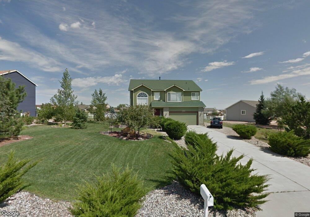
11310 Allendale Dr Peyton, CO 80831
Falcon NeighborhoodEstimated Value: $502,000 - $574,000
4
Beds
3
Baths
2,054
Sq Ft
$261/Sq Ft
Est. Value
About This Home
This home is located at 11310 Allendale Dr, Peyton, CO 80831 and is currently estimated at $537,117, approximately $261 per square foot. 11310 Allendale Dr is a home located in El Paso County with nearby schools including Bennett Ranch Elementary School, Falcon Middle School, and Falcon High School.
Ownership History
Date
Name
Owned For
Owner Type
Purchase Details
Closed on
Dec 22, 2000
Sold by
Va
Bought by
Grier Melvin
Current Estimated Value
Home Financials for this Owner
Home Financials are based on the most recent Mortgage that was taken out on this home.
Original Mortgage
$171,000
Outstanding Balance
$63,151
Interest Rate
7.73%
Estimated Equity
$473,966
Purchase Details
Closed on
Aug 25, 2000
Sold by
Countrywide Home Loans Inc
Bought by
Va
Purchase Details
Closed on
Aug 4, 2000
Sold by
Hart Robert J and Hart Helen A
Bought by
Countrywide Home Loans Inc
Purchase Details
Closed on
Jan 15, 1997
Sold by
Cucuzza Construction Inc
Bought by
Hart Robert J and Hart Helen A
Home Financials for this Owner
Home Financials are based on the most recent Mortgage that was taken out on this home.
Original Mortgage
$184,518
Interest Rate
7.43%
Mortgage Type
VA
Create a Home Valuation Report for This Property
The Home Valuation Report is an in-depth analysis detailing your home's value as well as a comparison with similar homes in the area
Home Values in the Area
Average Home Value in this Area
Purchase History
| Date | Buyer | Sale Price | Title Company |
|---|---|---|---|
| Grier Melvin | $180,000 | First American | |
| Va | $163,992 | -- | |
| Countrywide Home Loans Inc | $163,922 | -- | |
| Hart Robert J | $180,900 | Capital Title Services |
Source: Public Records
Mortgage History
| Date | Status | Borrower | Loan Amount |
|---|---|---|---|
| Open | Grier Melvin | $171,000 | |
| Previous Owner | Hart Robert J | $184,518 |
Source: Public Records
Tax History Compared to Growth
Tax History
| Year | Tax Paid | Tax Assessment Tax Assessment Total Assessment is a certain percentage of the fair market value that is determined by local assessors to be the total taxable value of land and additions on the property. | Land | Improvement |
|---|---|---|---|---|
| 2025 | $2,981 | $36,540 | -- | -- |
| 2024 | $2,808 | $37,090 | $9,000 | $28,090 |
| 2023 | $2,808 | $37,090 | $9,000 | $28,090 |
| 2022 | $2,293 | $25,230 | $7,390 | $17,840 |
| 2021 | $2,333 | $25,950 | $7,600 | $18,350 |
| 2020 | $1,960 | $21,660 | $4,680 | $16,980 |
| 2019 | $1,915 | $21,660 | $4,680 | $16,980 |
| 2018 | $1,528 | $16,790 | $3,280 | $13,510 |
| 2017 | $1,426 | $16,790 | $3,280 | $13,510 |
| 2016 | $1,413 | $16,820 | $3,620 | $13,200 |
| 2015 | $1,482 | $16,820 | $3,620 | $13,200 |
| 2014 | $1,367 | $15,290 | $3,340 | $11,950 |
Source: Public Records
Map
Nearby Homes
- 11430 Palmers Green Dr
- 9920 Glenellen Dr
- 9630 Liberty Grove Dr
- 11577 Cranston Dr
- 10068 Beckham St
- 9808 Jaggar Way
- 9936 Jaggar Way
- 9880 Jaggar Way
- 11250 Scenic Brush Dr
- 10926 Scenic Brush Dr
- 10530 Pictured Rocks Dr
- 10467 Pictured Rocks Dr
- 9740 Aberdale Ct
- 10442 Beckham St
- 10394 Beckham St
- 10111 Keating Dr
- 10488 Cedar Breaks Dr
- 10429 Cedar Breaks Dr
- 10753 Finsbury Ct
- 10921 Redington Dr
- 11330 Allendale Dr
- 11280 Allendale Dr
- 11268 Allendale Dr
- 11335 Cressman Dr
- 11345 Cressman Dr
- 11335 Allendale Dr
- 11325 Cressman Dr
- 11315 Allendale Dr
- 11305 Allendale Dr
- 11350 Allendale Dr
- 11256 Allendale Dr
- 11345 Allendale Dr
- 11355 Cressman Dr
- 11279 Allendale Dr
- 11355 Allendale Dr
- 11315 Cressman Dr
- 11267 Allendale Dr
- 11244 Allendale Dr
- 11321 Palmers Green Dr
- 11309 Palmers Green Dr