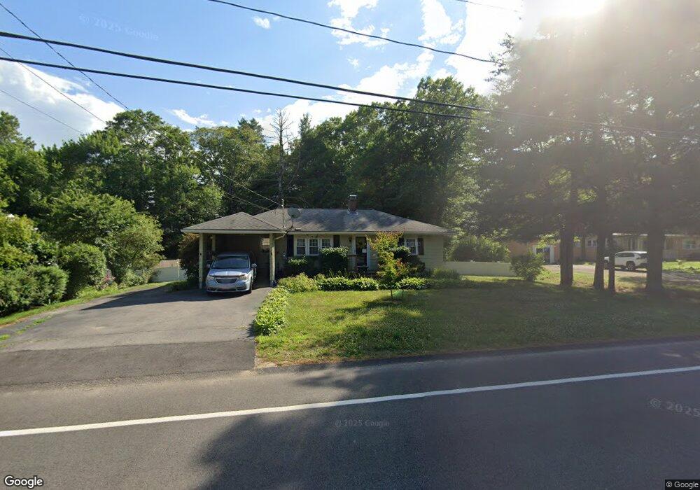
1132 Auburn St Whitman, MA 02382
Estimated Value: $494,000 - $501,000
2
Beds
1
Bath
1,358
Sq Ft
$366/Sq Ft
Est. Value
About This Home
This home is located at 1132 Auburn St, Whitman, MA 02382 and is currently estimated at $497,352, approximately $366 per square foot. 1132 Auburn St is a home located in Plymouth County with nearby schools including Trinity Catholic Academy, Brockton Area Seventh-Day Adventist Academy, and Cardinal Spellman High School.
Ownership History
Date
Name
Owned For
Owner Type
Purchase Details
Closed on
Mar 4, 2020
Sold by
Gilson Peter J and Gilson Janice E
Bought by
Gilson Ft
Current Estimated Value
Purchase Details
Closed on
Sep 14, 1998
Sold by
Cain John T and Cain Cheryl M
Bought by
Gilson Peter J and Gilson Janice E
Purchase Details
Closed on
Aug 25, 1989
Sold by
Panico Michael E
Bought by
Cain John T
Create a Home Valuation Report for This Property
The Home Valuation Report is an in-depth analysis detailing your home's value as well as a comparison with similar homes in the area
Home Values in the Area
Average Home Value in this Area
Purchase History
| Date | Buyer | Sale Price | Title Company |
|---|---|---|---|
| Gilson Ft | -- | None Available | |
| Gilson Peter J | $123,500 | -- | |
| Cain John T | $139,000 | -- |
Source: Public Records
Mortgage History
| Date | Status | Borrower | Loan Amount |
|---|---|---|---|
| Previous Owner | Cain John T | $50,000 | |
| Previous Owner | Cain John T | $126,000 | |
| Previous Owner | Cain John T | $122,500 |
Source: Public Records
Tax History Compared to Growth
Tax History
| Year | Tax Paid | Tax Assessment Tax Assessment Total Assessment is a certain percentage of the fair market value that is determined by local assessors to be the total taxable value of land and additions on the property. | Land | Improvement |
|---|---|---|---|---|
| 2025 | $5,461 | $416,200 | $220,000 | $196,200 |
| 2024 | $5,160 | $405,000 | $215,400 | $189,600 |
| 2023 | $4,931 | $363,400 | $187,200 | $176,200 |
| 2022 | $4,831 | $331,800 | $171,500 | $160,300 |
| 2021 | $4,483 | $289,200 | $151,200 | $138,000 |
| 2020 | $4,455 | $281,100 | $151,200 | $129,900 |
| 2019 | $4,180 | $271,800 | $151,200 | $120,600 |
| 2018 | $4,039 | $252,300 | $143,400 | $108,900 |
| 2017 | $3,805 | $252,300 | $143,400 | $108,900 |
| 2016 | $3,431 | $220,100 | $125,400 | $94,700 |
| 2015 | $3,503 | $224,400 | $125,400 | $99,000 |
Source: Public Records
Map
Nearby Homes
- 1121 Auburn St
- 26 Alger St
- 877 Auburnville Way Unit D4
- 99 Alger St
- 32 Joyce Terrace
- 307 Homeland Dr
- 104 Crestfield Dr
- 93 Porter St
- 262 Homeland Dr
- 728 Auburn St Unit F6
- 618 Auburn St
- 485 Temple St
- 967 Centre St
- 16 Davis St
- 78 Linda St
- 300 High St
- 24 Churchill Ave
- 91 Clapp St
- 59 Sterling Rd
- 63 Rice St
- 1120 Auburn St
- 1140 Auburn St
- 1135 Auburn St
- 1129 Auburn St
- 1100 Auburn St
- 1152 Auburn St
- 1179 Auburn St
- 1090 Auburn St
- 1199 Auburn St
- 7 Captain Allen Way
- 1055 Auburn St
- 1055 Auburn St Unit 1
- 15 Captain Allen Way
- 31 Captain Allen Way
- Lot 13 Captain Allen Way
- 1045 Auburn St Unit 1
- 10 Captain Allen Way
- 1225 Auburn St
- 61 Captain Allen Way
- 71 Captain Allen Way