Estimated Value: $438,887 - $515,000
3
Beds
3
Baths
2,808
Sq Ft
$171/Sq Ft
Est. Value
About This Home
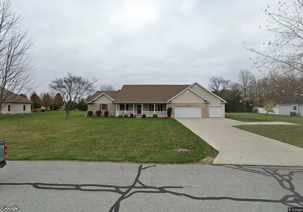
This home is located at 1132 W Buckskin Trail, Lima, OH 45807 and is currently estimated at $479,972, approximately $170 per square foot. 1132 W Buckskin Trail is a home located in Allen County with nearby schools including Elida Elementary School, Elida Middle School, and Elida High School.
Ownership History
Date
Name
Owned For
Owner Type
Purchase Details
Closed on
May 6, 2014
Sold by
Bible Michael L and Bible Nancy J
Bought by
Cox Anthony J and Cox Traci R
Current Estimated Value
Home Financials for this Owner
Home Financials are based on the most recent Mortgage that was taken out on this home.
Original Mortgage
$192,000
Outstanding Balance
$104,028
Interest Rate
4.41%
Mortgage Type
New Conventional
Estimated Equity
$375,944
Purchase Details
Closed on
Nov 22, 2000
Sold by
Deer Run Est Ltd
Bought by
Bible Michael L Nancy J
Create a Home Valuation Report for This Property
The Home Valuation Report is an in-depth analysis detailing your home's value as well as a comparison with similar homes in the area
Home Values in the Area
Average Home Value in this Area
Purchase History
| Date | Buyer | Sale Price | Title Company |
|---|---|---|---|
| Cox Anthony J | $240,000 | None Available | |
| Bible Michael L Nancy J | $35,500 | -- |
Source: Public Records
Mortgage History
| Date | Status | Borrower | Loan Amount |
|---|---|---|---|
| Open | Cox Anthony J | $192,000 |
Source: Public Records
Tax History Compared to Growth
Tax History
| Year | Tax Paid | Tax Assessment Tax Assessment Total Assessment is a certain percentage of the fair market value that is determined by local assessors to be the total taxable value of land and additions on the property. | Land | Improvement |
|---|---|---|---|---|
| 2024 | $5,507 | $126,140 | $20,160 | $105,980 |
| 2023 | $5,229 | $105,110 | $16,800 | $88,310 |
| 2022 | $5,243 | $105,110 | $16,800 | $88,310 |
| 2021 | $5,253 | $105,110 | $16,800 | $88,310 |
| 2020 | $4,885 | $90,520 | $15,860 | $74,660 |
| 2019 | $4,885 | $90,520 | $15,860 | $74,660 |
| 2018 | $4,642 | $90,520 | $15,860 | $74,660 |
| 2017 | $4,322 | $80,790 | $15,860 | $64,930 |
| 2016 | $4,286 | $80,790 | $15,860 | $64,930 |
| 2015 | $4,392 | $80,790 | $15,860 | $64,930 |
| 2014 | $4,392 | $80,010 | $15,540 | $64,470 |
| 2013 | $3,962 | $80,010 | $15,540 | $64,470 |
Source: Public Records
Map
Nearby Homes
- 00 Allentown Rd
- 0 Allentown Rd
- 1392 Chancellor Dr
- 1393 N Stevick Rd
- 3948 Chestnut Oak Trail
- 3637 Comanche Dr
- 3619 Comanche Dr
- 3687 Comanche
- 3705 Comanche
- 3624 Comanche Dr
- 3660 Comanche Dr
- 3790 Comanche Dr
- N/A Eastown Rd N
- 2956 W High St
- 4010 Neely Rd
- 2940 Koop Rd
- 174 Bridle Trail
- 2925 Koop Rd
- 8 Bridle Trail
- 224 Buckingham Dr
- 1178 W Buckskin Trail
- 1090 W Buckskin Trail
- 3737 Doe Ct
- 1133 W Buckskin Trail
- 1179 W Buckskin Trail
- 1066 W Buckskin Trail
- 3699 Doe Ct
- 3694 S Buckskin Trail
- 1087 W Buckskin Trail
- 3662 S Buckskin Trail
- 1255 W Buckskin Trail
- 1089 E Buckskin Trail
- 3698 Doe Ct
- 3710 Doe Ct
- 3600 Fawn Ct
- 1041 W Buckskin Trail
- 1193 E Buckskin Trail