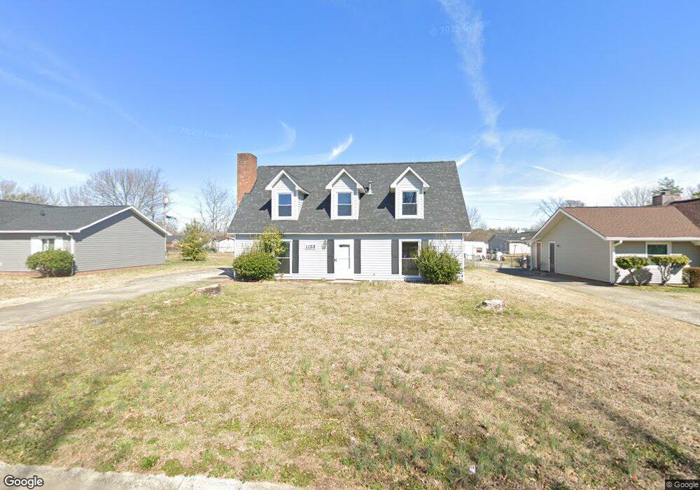
1133 Pearson Dr Rock Hill, SC 29730
Estimated Value: $233,000 - $287,000
--
Bed
1
Bath
1,729
Sq Ft
$147/Sq Ft
Est. Value
About This Home
This home is located at 1133 Pearson Dr, Rock Hill, SC 29730 and is currently estimated at $254,643, approximately $147 per square foot. 1133 Pearson Dr is a home with nearby schools including Mount Holly Elementary School, Saluda Trail Middle School, and Rock Hill High School.
Ownership History
Date
Name
Owned For
Owner Type
Purchase Details
Closed on
Jan 14, 2025
Sold by
Robbins Julia D and Robbins William Delaine
Bought by
Legacy Exchange Llc
Current Estimated Value
Home Financials for this Owner
Home Financials are based on the most recent Mortgage that was taken out on this home.
Original Mortgage
$231,000
Outstanding Balance
$209,365
Interest Rate
6.81%
Mortgage Type
Seller Take Back
Estimated Equity
$45,278
Purchase Details
Closed on
Dec 7, 2017
Sold by
Robbins W Delaine and Robbins William D
Bought by
Robbins William Delaine and Robbins Julia D
Create a Home Valuation Report for This Property
The Home Valuation Report is an in-depth analysis detailing your home's value as well as a comparison with similar homes in the area
Home Values in the Area
Average Home Value in this Area
Purchase History
| Date | Buyer | Sale Price | Title Company |
|---|---|---|---|
| Legacy Exchange Llc | $236,000 | None Listed On Document | |
| Legacy Exchange Llc | $236,000 | None Listed On Document | |
| Robbins William Delaine | -- | None Available |
Source: Public Records
Mortgage History
| Date | Status | Borrower | Loan Amount |
|---|---|---|---|
| Open | Legacy Exchange Llc | $231,000 | |
| Closed | Legacy Exchange Llc | $231,000 |
Source: Public Records
Tax History Compared to Growth
Tax History
| Year | Tax Paid | Tax Assessment Tax Assessment Total Assessment is a certain percentage of the fair market value that is determined by local assessors to be the total taxable value of land and additions on the property. | Land | Improvement |
|---|---|---|---|---|
| 2024 | $2,428 | $5,485 | $1,878 | $3,607 |
| 2023 | $2,431 | $5,485 | $1,878 | $3,607 |
| 2022 | $2,317 | $5,485 | $1,878 | $3,607 |
| 2021 | -- | $5,485 | $1,878 | $3,607 |
| 2020 | $2,271 | $5,485 | $0 | $0 |
| 2019 | $2,024 | $4,770 | $0 | $0 |
| 2018 | $1,994 | $4,770 | $0 | $0 |
| 2017 | $1,926 | $4,770 | $0 | $0 |
| 2016 | $1,887 | $4,770 | $0 | $0 |
| 2014 | $1,878 | $4,770 | $960 | $3,810 |
| 2013 | $1,878 | $4,950 | $960 | $3,990 |
Source: Public Records
Map
Nearby Homes
- 1104 Parkmont Ln
- 1212 Shenandoah Cir
- 1209 Shenandoah Cir
- 1361 Mount Holly Rd
- 263 Fairway Cir
- 264 Abigail Ct
- 1182 Saluda St
- 288 Fairway Cir
- 831 Yale St Unit 30
- 805 Brunswick Dr
- 1514 Van Ness Rd
- 1054 S Jones Avenue Extension
- 1025 S Jones Avenue Extension
- 846 Mallory Dr
- 914 Bunker Trace
- 706 Blake St
- 753 Schuyler Dr
- 172 Fairway Cir
- 421 Lakeside Dr
- 922 Bunker Trace
- 1127 Pearson Dr
- 1139 Pearson Dr
- 1121 Pearson Dr
- 1145 Pearson Dr
- 1140 Doris Cir Unit 21
- 1140 Doris Cir
- 1132 Pearson Dr
- 1138 Pearson Dr
- 1126 Pearson Dr
- 1144 Doris Cir
- 1151 Pearson Dr
- 1144 Pearson Dr
- 1120 Pearson Dr
- 1136 Doris Cir
- 912 Southland Dr
- 906 Southland Dr
- 902 Southland Dr
- 1157 Pearson Dr
- 1150 Pearson Dr
- 916 Southland Dr