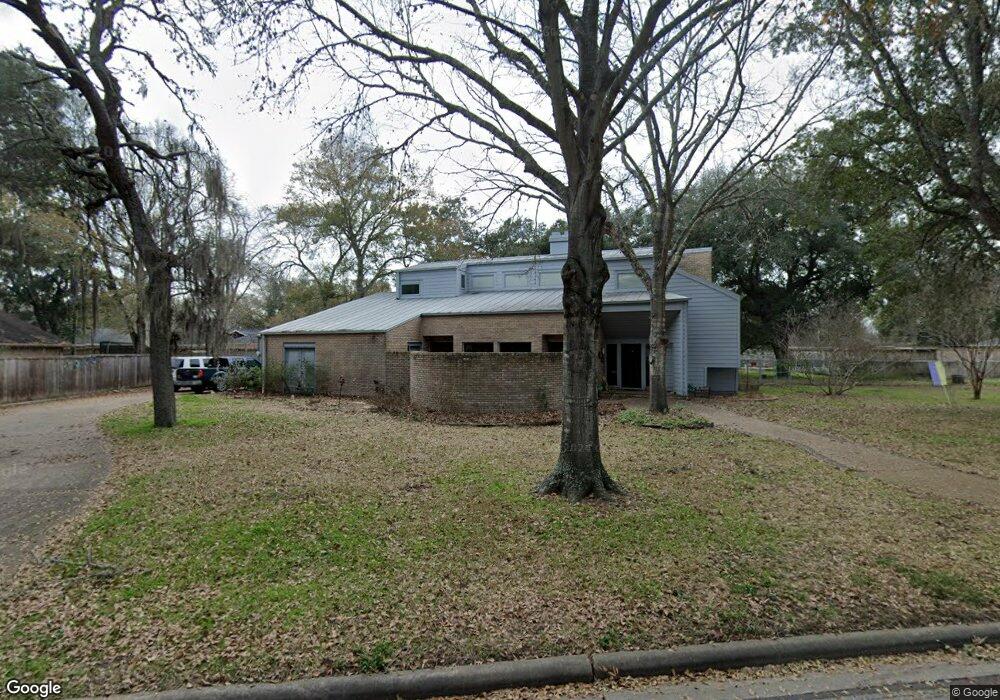
1134 Lindsey Dr Rosenberg, TX 77471
Estimated Value: $293,000 - $372,000
4
Beds
3
Baths
3,056
Sq Ft
$109/Sq Ft
Est. Value
About This Home
This home is located at 1134 Lindsey Dr, Rosenberg, TX 77471 and is currently estimated at $331,678, approximately $108 per square foot. 1134 Lindsey Dr is a home located in Fort Bend County with nearby schools including Smith Elementary School, J J Wessendorff Middle School, and Lamar Junior High School.
Ownership History
Date
Name
Owned For
Owner Type
Purchase Details
Closed on
Oct 13, 2017
Sold by
Louis Steve J
Bought by
Weir Richard and Weir Tempa
Current Estimated Value
Purchase Details
Closed on
Feb 13, 2017
Sold by
Knauth Knauth H and Knauth Ann O
Bought by
Louis Steve J
Home Financials for this Owner
Home Financials are based on the most recent Mortgage that was taken out on this home.
Original Mortgage
$227,000
Interest Rate
3.25%
Mortgage Type
Adjustable Rate Mortgage/ARM
Create a Home Valuation Report for This Property
The Home Valuation Report is an in-depth analysis detailing your home's value as well as a comparison with similar homes in the area
Home Values in the Area
Average Home Value in this Area
Purchase History
| Date | Buyer | Sale Price | Title Company |
|---|---|---|---|
| Weir Richard | -- | Chicago Title | |
| Louis Steve J | -- | Select Title Llc |
Source: Public Records
Mortgage History
| Date | Status | Borrower | Loan Amount |
|---|---|---|---|
| Previous Owner | Louis Steve J | $227,000 |
Source: Public Records
Tax History Compared to Growth
Tax History
| Year | Tax Paid | Tax Assessment Tax Assessment Total Assessment is a certain percentage of the fair market value that is determined by local assessors to be the total taxable value of land and additions on the property. | Land | Improvement |
|---|---|---|---|---|
| 2025 | $1,555 | $337,741 | $29,744 | $307,997 |
| 2024 | $1,555 | $378,912 | $29,301 | $349,611 |
| 2023 | $1,457 | $344,465 | $0 | $358,740 |
| 2022 | $3,101 | $313,150 | $0 | $349,120 |
| 2021 | $5,907 | $284,680 | $28,720 | $255,960 |
| 2020 | $5,493 | $258,800 | $28,720 | $230,080 |
| 2019 | $5,820 | $254,820 | $28,720 | $226,100 |
| 2018 | $5,925 | $255,280 | $28,720 | $226,560 |
| 2017 | $5,115 | $219,130 | $28,720 | $190,410 |
| 2016 | $4,650 | $199,210 | $28,720 | $170,490 |
| 2015 | $2,160 | $208,560 | $28,720 | $179,840 |
| 2014 | $2,172 | $189,600 | $28,720 | $160,880 |
Source: Public Records
Map
Nearby Homes
- 1109 Frances Dr
- 1809 Hawthorn Dr
- 1806 Cedar Dr
- 1805 Hawthorn Dr
- 4602 Avenue H
- 1922 Teakwood St
- 4502 River Rd
- 1004 Country Club Dr
- 512 and 514 Travis St
- 5121 Alderney Ct
- 000 Fm 2218 Rd
- 5002 Quebec Blvd
- 0 Fm 2218 Unit 25550047
- 5027 Quebec Blvd
- 2015 Tanglelane St
- 1230 Law Ct
- 0 Meadow Ln
- 5106 Alderney Ct
- 6219 Deep Gulch Dr
- 6215 Deep Gulch Dr
- 1202 Lindsey Dr
- 1139 Sally Anne Dr
- 1122 Lindsey Dr
- 1203 Sally Anne Dr
- 1135 Lindsey Dr
- 1129 Lindsey Dr
- 1121 Sally Anne Dr
- 1208 Lindsey Dr
- 1209 Sally Anne Dr
- 1123 Lindsey Dr
- 1203 Lindsey Dr
- 1115 Sally Anne Dr
- 1112 Lindsey Dr
- 1215 Sally Anne Dr
- 1117 Lindsey Dr
- 1214 Lindsey Dr
- 1132 Sally Anne Dr
- 1138 Sally Anne Dr
- 1132 Frances Dr
- 1138 Frances Dr