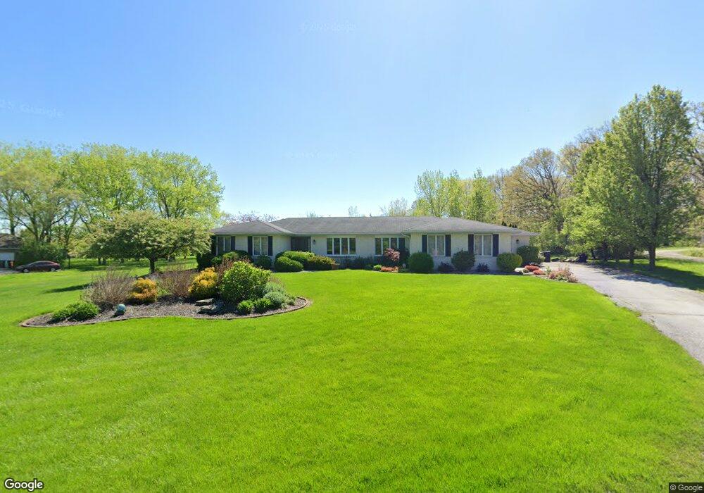
11347 Morton Ct Crown Point, IN 46307
Estimated Value: $474,000 - $545,037
4
Beds
3
Baths
2,386
Sq Ft
$212/Sq Ft
Est. Value
About This Home
This home is located at 11347 Morton Ct, Crown Point, IN 46307 and is currently estimated at $505,009, approximately $211 per square foot. 11347 Morton Ct is a home located in Lake County with nearby schools including Lake Street Elementary School, Robert Taft Middle School, and Crown Point High School.
Ownership History
Date
Name
Owned For
Owner Type
Purchase Details
Closed on
May 13, 2011
Sold by
Pollitt Robert
Bought by
Pollitt Robert A and Pollitt Jennifer A
Current Estimated Value
Purchase Details
Closed on
Oct 23, 2007
Sold by
Ercus Michael and Ercus Arlene
Bought by
Pollitt Robert
Home Financials for this Owner
Home Financials are based on the most recent Mortgage that was taken out on this home.
Original Mortgage
$251,200
Outstanding Balance
$157,802
Interest Rate
6.33%
Mortgage Type
Purchase Money Mortgage
Estimated Equity
$347,207
Create a Home Valuation Report for This Property
The Home Valuation Report is an in-depth analysis detailing your home's value as well as a comparison with similar homes in the area
Home Values in the Area
Average Home Value in this Area
Purchase History
| Date | Buyer | Sale Price | Title Company |
|---|---|---|---|
| Pollitt Robert A | -- | Chicago Title Insurance Co | |
| Pollitt Robert | -- | Stewart Title |
Source: Public Records
Mortgage History
| Date | Status | Borrower | Loan Amount |
|---|---|---|---|
| Open | Pollitt Robert | $251,200 |
Source: Public Records
Tax History Compared to Growth
Tax History
| Year | Tax Paid | Tax Assessment Tax Assessment Total Assessment is a certain percentage of the fair market value that is determined by local assessors to be the total taxable value of land and additions on the property. | Land | Improvement |
|---|---|---|---|---|
| 2024 | $8,129 | $398,800 | $65,700 | $333,100 |
| 2023 | $3,893 | $382,500 | $65,700 | $316,800 |
| 2022 | $3,893 | $364,700 | $65,700 | $299,000 |
| 2021 | $3,597 | $353,200 | $60,700 | $292,500 |
| 2020 | $3,651 | $341,200 | $60,700 | $280,500 |
| 2019 | $3,611 | $329,600 | $60,700 | $268,900 |
| 2018 | $3,698 | $320,400 | $60,700 | $259,700 |
| 2017 | $3,787 | $323,600 | $60,700 | $262,900 |
| 2016 | $3,739 | $318,500 | $60,100 | $258,400 |
| 2014 | $3,452 | $315,200 | $60,100 | $255,100 |
| 2013 | $6,135 | $314,600 | $60,100 | $254,500 |
Source: Public Records
Map
Nearby Homes
- 11341 Lakewood St
- 11531 Westvalley Dr
- 11606 Westvalley Dr
- 11224 Durbin Place
- 775 Quinlan Ct
- 10813 Lane St
- 1140 Hyde Park
- 908 Mary Ellen Dr
- 11217 Burr Parcel 2 St
- 1156 Donegal Ln
- 10710 Porter St
- 804 Shannon Dr
- 1144 Mary Ellen Dr
- 629 W South St
- 10729 Hanley St
- 1089 George Ade Ct
- 114 S Chase Dr
- 7830 W 106th Ln
- 7770 W 106th Ln
- 4714 W 121st Ave
- 11323 Morton Ct
- 11357 Morton Ct
- 11326 Morton Ct
- 11356 Morton Ct
- 4361 W 113th Ave
- 11360 Morton Ct
- 10205 W 113th Ave
- 11483 Baker St
- 11487 Baker St
- 11412 Lakewood St
- 11326 Lakewood St
- 11388 Lakewood St
- 11436 Lakewood St
- 11362 Lakewood St
- 11484 Baker St
- 11460 Lakewood St
- 11351 Westvalley Dr
- 11486 Lakewood St
- 11490 Baker St
- 11501 Baker St