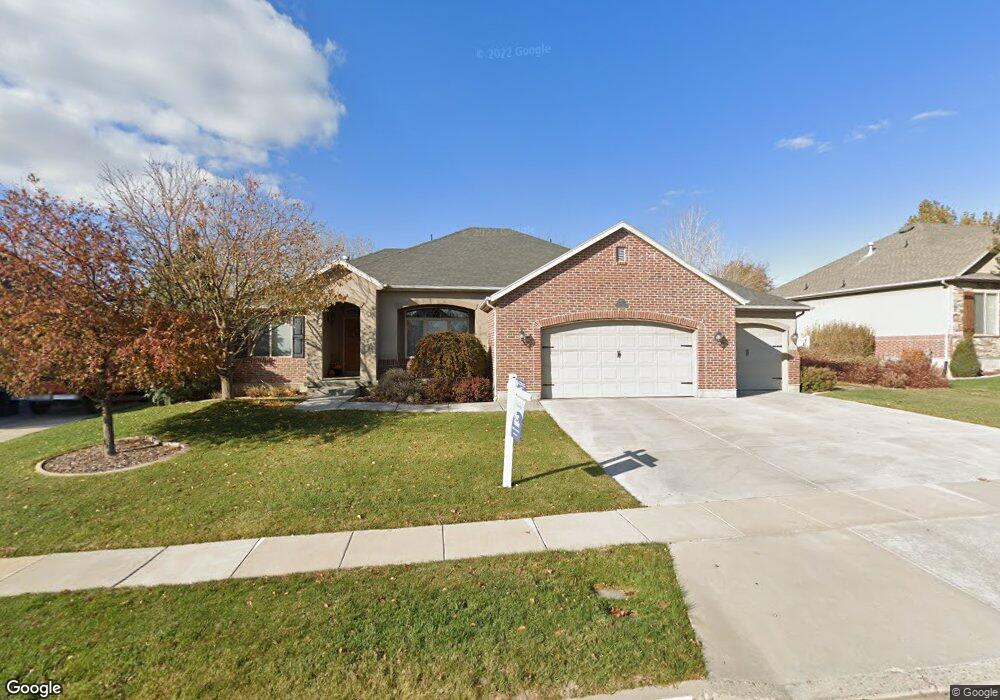
1135 E 425 N Layton, UT 84040
Estimated Value: $711,000 - $792,000
6
Beds
3
Baths
3,636
Sq Ft
$206/Sq Ft
Est. Value
About This Home
This home is located at 1135 E 425 N, Layton, UT 84040 and is currently estimated at $750,529, approximately $206 per square foot. 1135 E 425 N is a home located in Davis County with nearby schools including Whitesides Elementary School, Central Davis Junior High School, and Layton High School.
Ownership History
Date
Name
Owned For
Owner Type
Purchase Details
Closed on
Nov 11, 2022
Sold by
Nielson Marc and Nielson Suzanne
Bought by
Baumgart Jenna and Ray Gary A
Current Estimated Value
Home Financials for this Owner
Home Financials are based on the most recent Mortgage that was taken out on this home.
Original Mortgage
$644,000
Outstanding Balance
$623,381
Interest Rate
6.95%
Mortgage Type
New Conventional
Estimated Equity
$127,148
Purchase Details
Closed on
Oct 17, 2016
Sold by
Nielson Marc M and Nielson Suzanne K
Bought by
Nielson Marc and Nielson Suzanne
Purchase Details
Closed on
May 16, 2006
Sold by
Destination Homes Inc
Bought by
Nielson Marc M and Nielson Suzanne K
Purchase Details
Closed on
Oct 3, 2005
Sold by
Adamswood Landing Llc
Bought by
Destination Homes Inc
Create a Home Valuation Report for This Property
The Home Valuation Report is an in-depth analysis detailing your home's value as well as a comparison with similar homes in the area
Home Values in the Area
Average Home Value in this Area
Purchase History
| Date | Buyer | Sale Price | Title Company |
|---|---|---|---|
| Baumgart Jenna | -- | Investors Title | |
| Nielson Marc | -- | Meridian Title | |
| Nielson Marc M | -- | Bonneville Title Company | |
| Destination Homes Inc | -- | Bonneville Title Company |
Source: Public Records
Mortgage History
| Date | Status | Borrower | Loan Amount |
|---|---|---|---|
| Open | Baumgart Jenna | $644,000 |
Source: Public Records
Tax History
| Year | Tax Paid | Tax Assessment Tax Assessment Total Assessment is a certain percentage of the fair market value that is determined by local assessors to be the total taxable value of land and additions on the property. | Land | Improvement |
|---|---|---|---|---|
| 2025 | $3,542 | $371,800 | $131,827 | $239,973 |
| 2024 | $3,344 | $353,650 | $154,337 | $199,313 |
| 2023 | $3,348 | $624,000 | $205,296 | $418,704 |
| 2022 | $3,347 | $338,800 | $110,365 | $228,435 |
| 2021 | $3,319 | $501,000 | $168,357 | $332,643 |
| 2020 | $3,052 | $442,000 | $137,887 | $304,113 |
| 2019 | $2,926 | $415,000 | $122,836 | $292,164 |
| 2018 | $2,718 | $387,000 | $96,847 | $290,153 |
| 2016 | $2,541 | $186,615 | $66,039 | $120,576 |
| 2015 | $2,648 | $184,635 | $66,039 | $118,596 |
| 2014 | $2,423 | $172,758 | $66,039 | $106,719 |
| 2013 | -- | $152,767 | $37,540 | $115,227 |
Source: Public Records
Map
Nearby Homes
- 479 N 1375 E
- 1503 E 530 N
- 508 N Adamswood Rd
- 1515 E Gentile St
- 187 N Talbot Dr
- 556 N Fairfield Rd Unit A2
- 556 N Fairfield Rd Unit D1
- 556 N Fairfield Rd Unit D2
- 556 N Fairfield Rd Unit A3
- 556 N Fairfield Rd Unit D3
- 556 N Fairfield Rd Unit D4
- 556 N Fairfield Rd Unit A1
- 556 N Fairfield Rd Unit A4
- 861 E 575 N
- 1033 E 825 N
- 997 E 825 N
- 1690 E Gentile St
- 1137 Holmes Creek Ln
- 109 Beacon Ave
- 9 Colonial Ave
- 1136 E 425 N
- 1141 E 425 N
- 1131 E 425 N
- 1082 E 500 N
- 1102 E 500 N
- 1102 E 500 N Unit 7
- 1132 E 425 N
- 1147 E 425 N
- 1147 E 425 N Unit 129
- 1060 E 500 N
- 1144 E 425 N
- 475 N Franklin Rd
- 427 N 1050 E
- 504 N 1100 E
- 1148 E 425 N
- 377 N 1050 E
- 1199 Saint Joseph St
- 1185 E St Josephs St
- 1199 E St Josephs St
- 1185 Saint Joseph St
Your Personal Tour Guide
Ask me questions while you tour the home.