


Estimated payment $2,652/month
Highlights
- Barn
- Deck
- Central Air
- 60 Acre Lot
- Pond
- Ceiling Fan
About This Lot
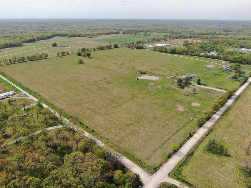
Wide Open Spaces! 60 acres m/l of grazing pasture all fenced with 2 ponds and a hay barn. 4 bedroom, 3 bathroom home with 2 living areas, open kitchen to dining and room for an office. Property is presently used for hay production and grazing. Lots of room to roam!
Let's go take a look! $475,000
Listing Agent
Cunningham & Associates Real Estate Brokerage Phone: 918-557-2624 License #142346 Listed on: 11/17/2025
Property Details
Property Type
- Land
Est. Annual Taxes
- $1,367
Year Built
- Built in 2021
Lot Details
- 60 Acre Lot
- Fenced
- Level Lot
- Cleared Lot
- 210088301
Home Design
- Permanent Foundation
- Vinyl Siding
Interior Spaces
- 2,432 Sq Ft Home
- 1-Story Property
- Ceiling Fan
Kitchen
- Electric Oven
- Range Hood
- Dishwasher
Bedrooms and Bathrooms
- 4 Bedrooms
- 3 Full Bathrooms
Parking
- 1 Car Garage
- Carport
Outdoor Features
- Pond
- Deck
Schools
- Jay High School
Farming
- Barn
Utilities
- Central Air
- Furnace
- Septic Tank
Listing and Financial Details
- Assessor Parcel Number 210033648
Map
Tax History
| Year | Tax Paid | Tax Assessment Tax Assessment Total Assessment is a certain percentage of the fair market value that is determined by local assessors to be the total taxable value of land and additions on the property. | Land | Improvement |
|---|---|---|---|---|
| 2025 | $1,379 | $15,472 | $2,175 | $13,297 |
| 2024 | $1,340 | $15,021 | $2,112 | $12,909 |
| 2023 | $1,340 | $14,584 | $1,831 | $12,753 |
| 2022 | $1,269 | $14,584 | $1,831 | $12,753 |
| 2021 | $1,085 | $14,159 | $1,831 | $12,328 |
| 2020 | $231 | $2,845 | $1,948 | $897 |
| 2019 | $807 | $9,878 | $1,948 | $7,930 |
Property History
| Date | Event | Price | List to Sale | Price per Sq Ft |
|---|---|---|---|---|
| 02/02/2026 02/02/26 | Pending | -- | -- | -- |
| 11/17/2025 11/17/25 | For Sale | $475,000 | -- | $195 / Sq Ft |
Purchase History
| Date | Type | Sale Price | Title Company |
|---|---|---|---|
| Interfamily Deed Transfer | -- | First American Title Ins Co | |
| Warranty Deed | $170,000 | Grand River Abstract & Title |
Mortgage History
| Date | Status | Loan Amount | Loan Type |
|---|---|---|---|
| Open | $102,800 | Future Advance Clause Open End Mortgage |
Source: Northeast Oklahoma Board of REALTORS®
MLS Number: 25-2451
APN: 0033648
Disclaimer: Certain information contained herein is derived from information provided by parties other than Homes.com. All information provided is deemed reliable, but is not guaranteed to be accurate and should be independently verified.
![]() IDX information is provided exclusively for personal, non-commercial use, and may not be used for any purpose other than to identify prospective properties consumers may be interested in purchasing. Information is deemed reliable but not guaranteed.
IDX information is provided exclusively for personal, non-commercial use, and may not be used for any purpose other than to identify prospective properties consumers may be interested in purchasing. Information is deemed reliable but not guaranteed.
- 0 E 380 Rd Unit 2608547
- 0 E 380 Rd Unit 2601270
- TBD S 622 Rd
- 908 W Osage
- XXX S 590 Rd
- 0000 E 480
- Lot 14 Block 6 (Piney Woods) E 330 Rd
- Lot 6 Block 12 (Piney Woods) S 576 Rd
- Lot 7 Block 12 (Piney Woods) S 576 Rd
- Lot 16 Block 6 (Piney Woods) E 330 Rd
- Lot 26 Block 14 (Piney Woods) S 576 Rd
- 64492 E 350 Rd
- Lot 8 Block 12 (Piney Woods) S 576 Rd
- 0 N Main St
- 55122 E 360 Rd
- 55130 E 360 Rd
- 55124 E 360 Rd
- 55126 E 360 Rd
- TBD W Leonard St
- 35800 S 590 Rd

Ask me questions while you tour the home.