Estimated Value: $195,000 - $275,000
3
Beds
3
Baths
2,352
Sq Ft
$104/Sq Ft
Est. Value
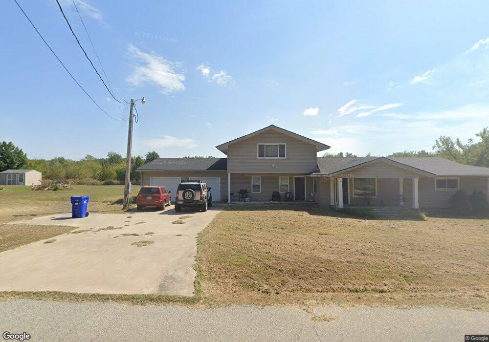
About This Home
This home is located at 11370 S 590 Rd, Miami, OK 74354 and is currently estimated at $244,872, approximately $104 per square foot. 11370 S 590 Rd is a home located in Ottawa County with nearby schools including Miami High School.
Ownership History
Date
Name
Owned For
Owner Type
Purchase Details
Closed on
Dec 15, 2020
Sold by
Buxani John and Buxani Terri
Bought by
Hughes Sarah M
Current Estimated Value
Home Financials for this Owner
Home Financials are based on the most recent Mortgage that was taken out on this home.
Original Mortgage
$159,595
Outstanding Balance
$141,760
Interest Rate
2.7%
Mortgage Type
New Conventional
Estimated Equity
$103,112
Purchase Details
Closed on
Aug 9, 2012
Sold by
Berry Michael W and Berry Christiana M
Bought by
Buxani John and Buxani Terry
Create a Home Valuation Report for This Property
The Home Valuation Report is an in-depth analysis detailing your home's value as well as a comparison with similar homes in the area
Home Values in the Area
Average Home Value in this Area
Purchase History
| Date | Buyer | Sale Price | Title Company |
|---|---|---|---|
| Hughes Sarah M | $158,000 | Apex Title Northeast Ok Llc | |
| Buxani John | -- | None Available |
Source: Public Records
Mortgage History
| Date | Status | Borrower | Loan Amount |
|---|---|---|---|
| Open | Hughes Sarah M | $159,595 |
Source: Public Records
Tax History Compared to Growth
Tax History
| Year | Tax Paid | Tax Assessment Tax Assessment Total Assessment is a certain percentage of the fair market value that is determined by local assessors to be the total taxable value of land and additions on the property. | Land | Improvement |
|---|---|---|---|---|
| 2025 | $1,640 | $18,012 | $374 | $17,638 |
| 2024 | $1,640 | $18,012 | $374 | $17,638 |
| 2023 | $1,640 | $18,012 | $374 | $17,638 |
| 2022 | $1,573 | $18,012 | $374 | $17,638 |
| 2021 | $1,608 | $18,012 | $374 | $17,638 |
| 2020 | $1,351 | $15,182 | $385 | $14,797 |
| 2019 | $1,164 | $15,182 | $385 | $14,797 |
| 2018 | $1,172 | $15,182 | $385 | $14,797 |
| 2017 | $1,204 | $15,333 | $385 | $14,948 |
| 2016 | $1,116 | $14,886 | $2,301 | $12,585 |
| 2015 | $1 | $14 | $14 | $0 |
| 2014 | $1,137 | $14,886 | $2,301 | $12,585 |
Source: Public Records
Map
Nearby Homes
- 11631 S 587 Rd
- 11703 S 587 Rd
- 59608 W Peoria Cir
- 10526 S 590 Rd
- 11801 S 600 Rd
- 58920 E 102 Rd
- 0 E 110 Rd Unit 25-2147
- 59501 E 100 Rd
- 9985 S 593 Rd
- 0 S 600 Rd Unit 24321477
- 57040 E 131 Rd
- 17 S Elm St
- 60901 E 130 Rd
- 0 S Arrow Rd Unit 24-1901
- 60250 E 90 Rd
- 229 K St SE
- 900 E Steve Owens Blvd
- 200 K St SE
- 9851 S 614 Rd
- 9021 S 614 Rd Unit Lot 4