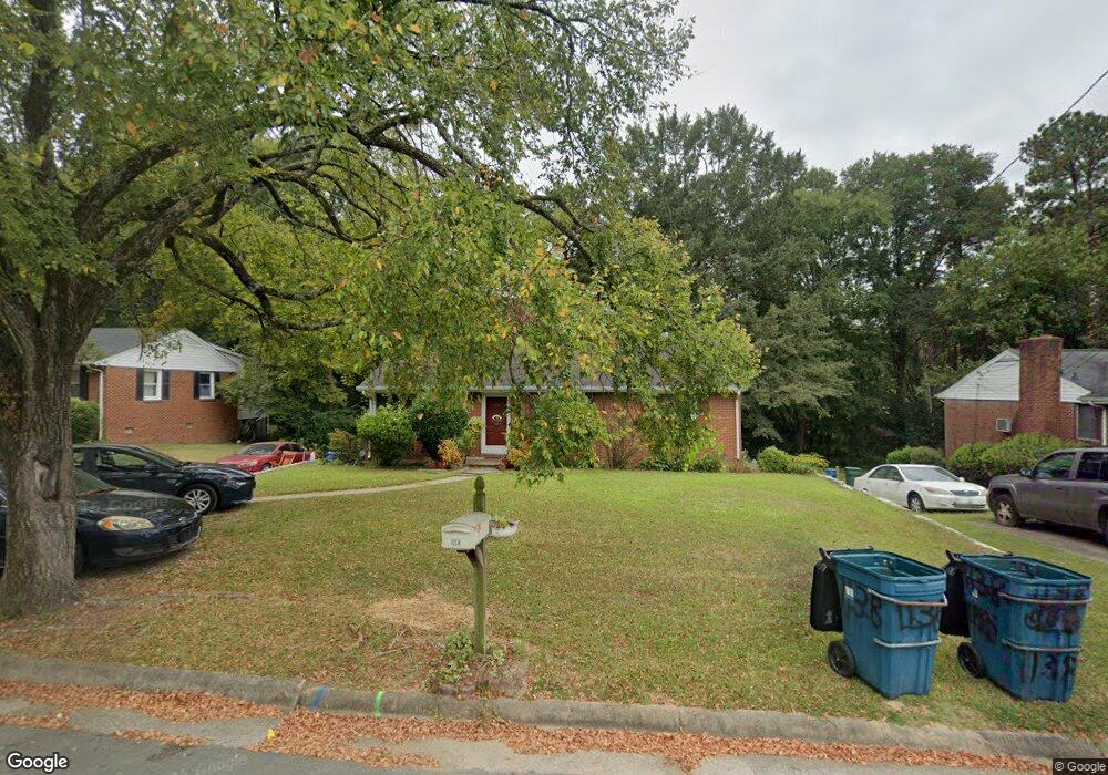
1138 Delano St Durham, NC 27703
East Durham NeighborhoodEstimated Value: $211,000 - $272,227
3
Beds
1
Bath
1,050
Sq Ft
$238/Sq Ft
Est. Value
About This Home
This home is located at 1138 Delano St, Durham, NC 27703 and is currently estimated at $250,307, approximately $238 per square foot. 1138 Delano St is a home located in Durham County with nearby schools including Y E Smith Elementary, W.G. Pearson Elementary School, and Brogden Middle.
Ownership History
Date
Name
Owned For
Owner Type
Purchase Details
Closed on
Oct 18, 2016
Sold by
Maye Freddie
Bought by
Maye Freddie and Maye Anna H
Current Estimated Value
Home Financials for this Owner
Home Financials are based on the most recent Mortgage that was taken out on this home.
Original Mortgage
$29,000
Outstanding Balance
$13,603
Interest Rate
3.48%
Mortgage Type
New Conventional
Estimated Equity
$236,704
Create a Home Valuation Report for This Property
The Home Valuation Report is an in-depth analysis detailing your home's value as well as a comparison with similar homes in the area
Home Values in the Area
Average Home Value in this Area
Purchase History
| Date | Buyer | Sale Price | Title Company |
|---|---|---|---|
| Maye Freddie | -- | -- |
Source: Public Records
Mortgage History
| Date | Status | Borrower | Loan Amount |
|---|---|---|---|
| Open | Maye Freddie | $29,000 |
Source: Public Records
Tax History
| Year | Tax Paid | Tax Assessment Tax Assessment Total Assessment is a certain percentage of the fair market value that is determined by local assessors to be the total taxable value of land and additions on the property. | Land | Improvement |
|---|---|---|---|---|
| 2025 | $2,800 | $282,436 | $102,000 | $180,436 |
| 2024 | $1,939 | $139,004 | $20,340 | $118,664 |
| 2023 | $1,821 | $139,004 | $20,340 | $118,664 |
| 2022 | $1,779 | $139,004 | $20,340 | $118,664 |
| 2021 | $1,771 | $139,004 | $20,340 | $118,664 |
| 2020 | $1,729 | $139,004 | $20,340 | $118,664 |
| 2019 | $1,729 | $139,004 | $20,340 | $118,664 |
| 2018 | $1,613 | $118,938 | $23,730 | $95,208 |
| 2017 | $1,602 | $118,938 | $23,730 | $95,208 |
| 2016 | $1,548 | $118,938 | $23,730 | $95,208 |
| 2015 | $1,524 | $110,098 | $25,393 | $84,705 |
| 2014 | $1,524 | $110,098 | $25,393 | $84,705 |
Source: Public Records
Map
Nearby Homes
- 1147 Delano St
- 1116 Delano St
- 681 Muldee St
- 1139 N Miami Blvd
- 1606C Juniper St
- 1606 Juniper St
- 1606D Juniper St
- 1609 Juniper St
- 212 Southerland St
- 1605 Kilmer Terrace
- 1505 Juniper St
- 113 Herbert St
- 525 N Hoover Rd
- 612 Raynor St
- 610 Raynor St
- 1601 Lathrop St
- 702 Brye St
- 1004 Park Ave
- 1501 Lathrop St
- 504 Raynor St
Your Personal Tour Guide
Ask me questions while you tour the home.