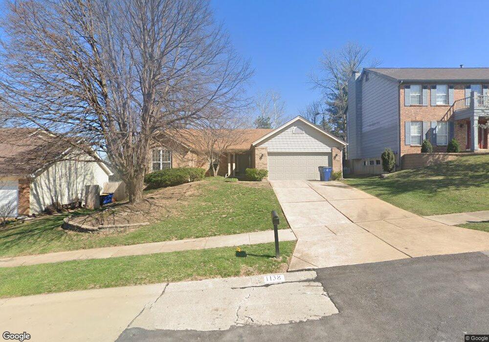
1138 Dunston Dr Saint Louis, MO 63146
Estimated Value: $372,867 - $462,000
3
Beds
2
Baths
1,862
Sq Ft
$234/Sq Ft
Est. Value
About This Home
This home is located at 1138 Dunston Dr, Saint Louis, MO 63146 and is currently estimated at $435,717, approximately $234 per square foot. 1138 Dunston Dr is a home located in St. Louis County with nearby schools including Willow Brook Elementary School, Pattonville Heights Middle School, and Pattonville High School.
Ownership History
Date
Name
Owned For
Owner Type
Purchase Details
Closed on
Feb 9, 2009
Sold by
Giacomo Harlan R and Giacomo Sharon E
Bought by
Giacomo Harlan R
Current Estimated Value
Home Financials for this Owner
Home Financials are based on the most recent Mortgage that was taken out on this home.
Original Mortgage
$495,000
Outstanding Balance
$280,628
Interest Rate
3.24%
Mortgage Type
Reverse Mortgage Home Equity Conversion Mortgage
Estimated Equity
$155,089
Purchase Details
Closed on
Dec 19, 1997
Sold by
Smith Mark S and Smith Anna M
Bought by
Giacomo Harlan R and Giacomo Sharon E
Home Financials for this Owner
Home Financials are based on the most recent Mortgage that was taken out on this home.
Original Mortgage
$154,400
Interest Rate
7.18%
Create a Home Valuation Report for This Property
The Home Valuation Report is an in-depth analysis detailing your home's value as well as a comparison with similar homes in the area
Home Values in the Area
Average Home Value in this Area
Purchase History
| Date | Buyer | Sale Price | Title Company |
|---|---|---|---|
| Giacomo Harlan R | -- | None Available | |
| Giacomo Harlan R | -- | -- |
Source: Public Records
Mortgage History
| Date | Status | Borrower | Loan Amount |
|---|---|---|---|
| Open | Giacomo Harlan R | $495,000 | |
| Closed | Giacomo Harlan R | $154,400 |
Source: Public Records
Tax History Compared to Growth
Tax History
| Year | Tax Paid | Tax Assessment Tax Assessment Total Assessment is a certain percentage of the fair market value that is determined by local assessors to be the total taxable value of land and additions on the property. | Land | Improvement |
|---|---|---|---|---|
| 2025 | $4,373 | $64,680 | $12,410 | $52,270 |
| 2024 | $4,373 | $62,450 | $6,610 | $55,840 |
| 2023 | $4,390 | $62,450 | $6,610 | $55,840 |
| 2022 | $4,000 | $51,780 | $9,920 | $41,860 |
| 2021 | $3,979 | $51,780 | $9,920 | $41,860 |
| 2020 | $3,989 | $49,860 | $9,920 | $39,940 |
| 2019 | $3,964 | $49,860 | $9,920 | $39,940 |
| 2018 | $3,859 | $44,500 | $9,920 | $34,580 |
| 2017 | $3,869 | $44,500 | $9,920 | $34,580 |
| 2016 | $4,071 | $45,960 | $11,570 | $34,390 |
| 2015 | $4,010 | $45,960 | $11,570 | $34,390 |
| 2014 | $4,122 | $46,840 | $9,390 | $37,450 |
Source: Public Records
Map
Nearby Homes
- 50 Willow Brook Dr
- 1060 Port Diane Dr
- 1279 Guelbreth Ln Unit 210
- 1054 Willow Brook Dr
- 1251 Guelbreth Ln Unit 308
- 10387 Forest Brook Ln
- 10360 Forest Brook Ln Unit G
- 1033 Wilton Royal Dr Unit 210
- 1033 Wilton Royal Dr Unit 107
- 1033 Wilton Royal Dr Unit 204
- 10401 Briarbend Dr Unit 2
- 10381 Oxford Hill Dr Unit 24
- 10381 Oxford Hill Dr Unit 14
- 10381 Oxford Hill Dr Unit 6
- 10367 Oxford Hill Dr Unit 14
- 10367 Oxford Hill Dr Unit 6
- 10367 Oxford Hill Dr Unit 26
- 10352 Forest Brook Ln Unit H
- 10469 Briarbend Dr Unit 3
- 970 N Spoede Rd Unit 24
- 1142 Dunston Dr
- 1134 Dunston Dr
- 1130 Dunston Dr
- 1146 Dunston Dr
- 92 Pebblebrook Ln
- 1137 Dunston Dr
- 1133 Dunston Dr
- 32 Deerfield Ln
- 91 Pebblebrook Ln
- 93 Pebblebrook Ln
- 1141 Dunston Dr
- 1129 Dunston Dr
- 1126 Dunston Dr
- 1150 Dunston Dr
- 1145 Dunston Dr
- 33 Deerfield Ln
- 31 Fernwood Ln
- 94 Pebblebrook Ln
- 1122 Dunston Dr
- 11150 Fairborough Ct