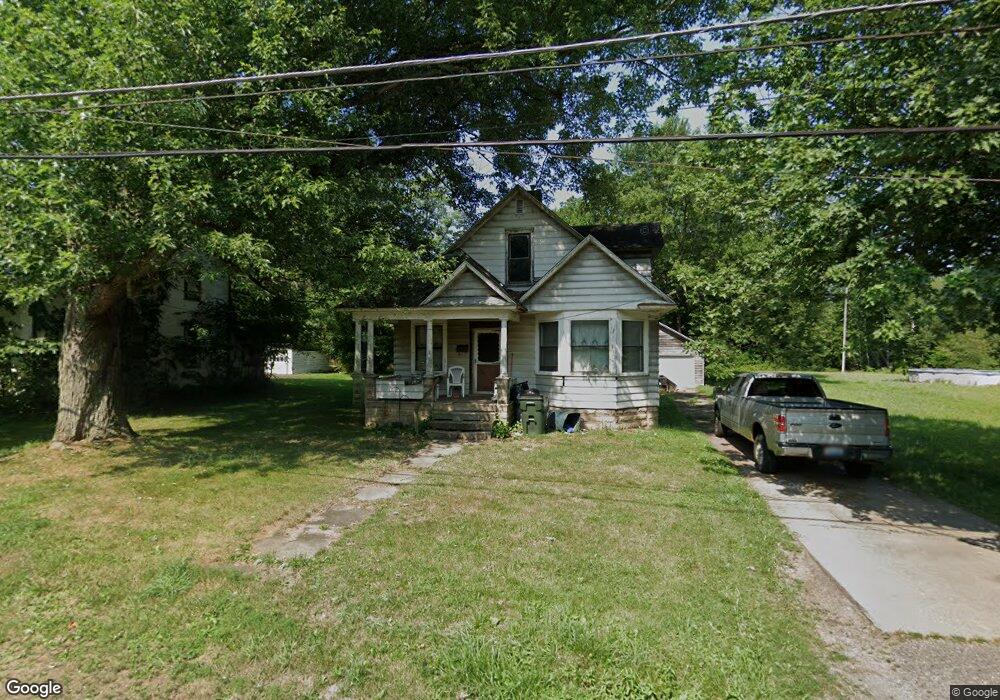
11393 Walnut Ave NE Alliance, OH 44601
Estimated Value: $57,000 - $97,000
2
Beds
1
Bath
1,632
Sq Ft
$52/Sq Ft
Est. Value
About This Home
This home is located at 11393 Walnut Ave NE, Alliance, OH 44601 and is currently estimated at $84,195, approximately $51 per square foot. 11393 Walnut Ave NE is a home located in Stark County with nearby schools including Alliance Early Learning School, Alliance Intermediate School at Northside, and Alliance Middle School.
Ownership History
Date
Name
Owned For
Owner Type
Purchase Details
Closed on
Sep 28, 2021
Sold by
Shearrow Charles C
Bought by
Shearrow Charles C and The Charles C Shearrow Trust
Current Estimated Value
Purchase Details
Closed on
Nov 2, 2018
Sold by
Shearrow Brain E and Estate Of Edward W Shearrow
Bought by
Shearrow Charles C
Purchase Details
Closed on
Oct 17, 2018
Sold by
Estate Of Carol L Shearrow
Bought by
Shearrow Edward W
Purchase Details
Closed on
May 27, 1999
Sold by
Estate Of Carol L Shearrow
Bought by
Shearrow Edward W
Create a Home Valuation Report for This Property
The Home Valuation Report is an in-depth analysis detailing your home's value as well as a comparison with similar homes in the area
Home Values in the Area
Average Home Value in this Area
Purchase History
| Date | Buyer | Sale Price | Title Company |
|---|---|---|---|
| Shearrow Charles C | -- | None Available | |
| Shearrow Charles C | -- | None Available | |
| Shearrow Edward W | -- | None Available | |
| Shearrow Edward W | -- | -- |
Source: Public Records
Tax History Compared to Growth
Tax History
| Year | Tax Paid | Tax Assessment Tax Assessment Total Assessment is a certain percentage of the fair market value that is determined by local assessors to be the total taxable value of land and additions on the property. | Land | Improvement |
|---|---|---|---|---|
| 2025 | -- | $18,700 | $10,610 | $8,090 |
| 2024 | $1,536 | $18,700 | $10,610 | $8,090 |
| 2023 | $1,536 | $20,580 | $8,680 | $11,900 |
| 2022 | $885 | $20,580 | $8,680 | $11,900 |
| 2021 | $886 | $20,580 | $8,680 | $11,900 |
| 2020 | $827 | $17,780 | $7,490 | $10,290 |
| 2019 | $817 | $17,790 | $7,490 | $10,300 |
| 2018 | $417 | $17,790 | $7,490 | $10,300 |
| 2017 | $312 | $15,020 | $5,530 | $9,490 |
| 2016 | $621 | $21,140 | $5,530 | $15,610 |
| 2015 | $600 | $21,140 | $5,530 | $15,610 |
| 2014 | $540 | $19,260 | $5,040 | $14,220 |
| 2013 | $268 | $19,260 | $5,040 | $14,220 |
Source: Public Records
Map
Nearby Homes
- 11344 Walnut Ave NE
- 11680 Walnut Ave NE
- 11310 Webb Ave NE
- 15995 Elbrook St NE
- 124 E Wayne St
- 652 N Webb Ave
- 710 N Freedom Ave
- 263 Franklin Ave
- 361 E Main St
- 14723 Bolton St NE
- 0 Meadowbrook Ave
- 000 Meadowbrook Ave
- 511 W Ely St
- 0 Homestead Ave NE
- 142 S Seneca Ave
- 1214 Jersey St
- 163 W Market St
- 329 1/2 W Main St
- 356 E Broadway St
- 0 Johnson Ave NE Unit 5142926
- 11381 Walnut Ave NE
- 11371 Walnut Ave NE
- 11384 Walnut Ave NE
- 11400 Walnut Ave NE
- 11377 Walnut Ave NE
- 11360 Walnut Ave NE
- 11441 Walnut Ave NE
- 11325 Walnut Ave NE
- 1216 Walnut Ave
- 11460 Walnut Ave NE
- 11460 Walnut Ave NE
- 11455 Walnut Ave NE
- 11322 Walnut Ave NE
- 11322 Walnut Ave NE
- 1201 Walnut Ave
- 330 Beech St
- 1152 Walnut Ave
- 1152 Walnut Ave
- 340 Beech St
- 346 Beech St