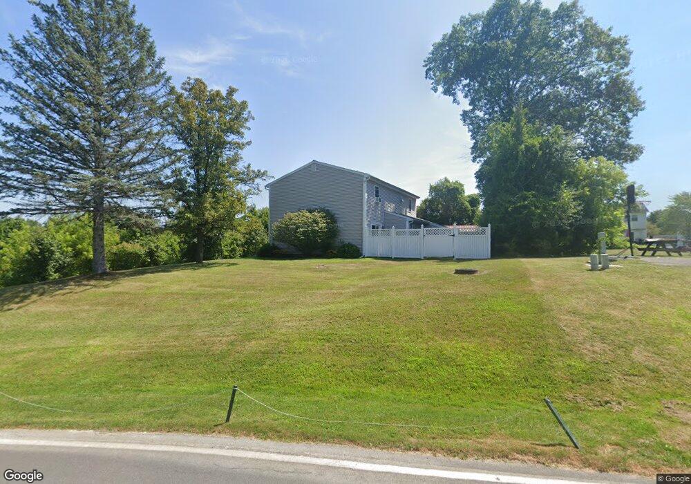
114-11 Rockerfeller Rd Bethlehem, NY 12054
Estimated Value: $412,243 - $483,000
4
Beds
2
Baths
2,338
Sq Ft
$189/Sq Ft
Est. Value
About This Home
This home is located at 114-11 Rockerfeller Rd, Bethlehem, NY 12054 and is currently estimated at $442,561, approximately $189 per square foot. 114-11 Rockerfeller Rd is a home located in Albany County with nearby schools including St. Thomas the Apostle School and Academy of the Holy Names.
Ownership History
Date
Name
Owned For
Owner Type
Purchase Details
Closed on
Nov 13, 2023
Sold by
Palella Irene M and Seeberger William A
Bought by
Palella Irene M and Seeberger William A
Current Estimated Value
Purchase Details
Closed on
May 14, 2015
Sold by
Bwg Llc
Bought by
Williams Christopher R
Home Financials for this Owner
Home Financials are based on the most recent Mortgage that was taken out on this home.
Original Mortgage
$258,726
Interest Rate
3.65%
Mortgage Type
FHA
Purchase Details
Closed on
Jun 26, 2009
Sold by
Seeberger William A and Palella Irene M
Bought by
Seeberger William A and Palella Irene M
Purchase Details
Closed on
Jun 12, 2003
Sold by
Warner Wm
Bought by
Seeberger Wm
Purchase Details
Closed on
Jul 9, 1998
Sold by
Johnson Wayne and Johnson Barbara
Bought by
Warner William F and Plunkett Terri L
Create a Home Valuation Report for This Property
The Home Valuation Report is an in-depth analysis detailing your home's value as well as a comparison with similar homes in the area
Home Values in the Area
Average Home Value in this Area
Purchase History
| Date | Buyer | Sale Price | Title Company |
|---|---|---|---|
| Palella Irene M | -- | None Listed On Document | |
| Williams Christopher R | $263,500 | None Available | |
| Seeberger William A | -- | None Available | |
| Seeberger Wm | $127,500 | -- | |
| Warner William F | $120,800 | -- |
Source: Public Records
Mortgage History
| Date | Status | Borrower | Loan Amount |
|---|---|---|---|
| Previous Owner | Williams Christopher R | $258,726 |
Source: Public Records
Tax History
| Year | Tax Paid | Tax Assessment Tax Assessment Total Assessment is a certain percentage of the fair market value that is determined by local assessors to be the total taxable value of land and additions on the property. | Land | Improvement |
|---|---|---|---|---|
| 2025 | $7,472 | $242,000 | $66,700 | $175,300 |
| 2024 | $7,472 | $242,000 | $66,700 | $175,300 |
| 2023 | $7,211 | $242,000 | $66,700 | $175,300 |
| 2022 | $7,008 | $242,000 | $66,700 | $175,300 |
| 2021 | $7,048 | $242,000 | $66,700 | $175,300 |
| 2020 | $7,008 | $242,000 | $66,700 | $175,300 |
| 2019 | $6,587 | $242,000 | $66,700 | $175,300 |
| 2018 | $6,854 | $242,000 | $66,700 | $175,300 |
| 2017 | $4,700 | $242,000 | $66,700 | $175,300 |
| 2016 | $6,724 | $242,000 | $66,700 | $175,300 |
| 2015 | -- | $242,000 | $66,700 | $175,300 |
| 2014 | -- | $242,000 | $66,700 | $175,300 |
Source: Public Records
Map
Nearby Homes
- 27 Wexford Rd
- 23 Woodmont Dr
- 484 Kenwood Ave
- 60 Fernbank Ave
- 525 Kenwood Ave
- 30 Willow Dr
- 2 Leaf Rd
- 8 Wedge Rd
- 616 Kenwood Ave
- 10 Canterbury Ln
- 23 Canterbury Ln
- 25 Canterbury Ln
- 43 Harrison Ave
- 264 Kenwood Ave
- 3 Groesbeck Place
- 6 Flint Dr
- 17 Camden Cir
- 667 Feura Bush Rd
- 32 Slingerlands St
- 642 Feura Bush Rd
- 45 Patterson Dr
- 33 Trinity
- 10 Tamarack Dr
- 4 Tamarack Dr
- 58 Oldox Rd
- 13 Tamarack Dr
- 18 Tamarack Dr
- 62 Oldox Rd
- 17 Tamarack Dr
- 50 Oldox Rd
- 0 Parcel #895 Spore Rd
- 0 Parcel # 427 Spore Rd Unit 29110452
- 0 Parcel # 427 Spore Rd
- 50 Old ox Rd
- 62 Old ox Rd
- 20 Tamarack Dr
- 66 Oldox Rd
- 21 Tamarack Dr
- 100 Mosher Rd
- 48 Oldox Rd
Your Personal Tour Guide
Ask me questions while you tour the home.