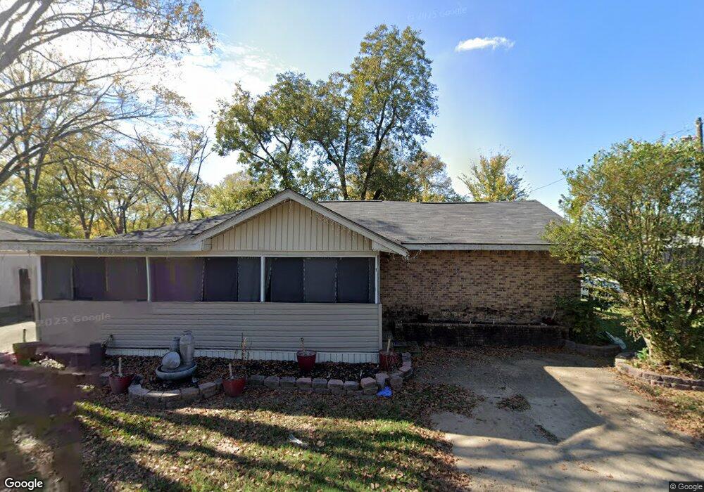
114 Bancroft Blvd West Monroe, LA 71292
Brownsville NeighborhoodEstimated Value: $77,000 - $110,000
3
Beds
2
Baths
1,650
Sq Ft
$54/Sq Ft
Est. Value
About This Home
This home is located at 114 Bancroft Blvd, West Monroe, LA 71292 and is currently estimated at $88,446, approximately $53 per square foot. 114 Bancroft Blvd is a home located in Ouachita Parish with nearby schools including Riverbend Elementary School, Riser Middle School, and West Monroe High School.
Ownership History
Date
Name
Owned For
Owner Type
Purchase Details
Closed on
May 23, 2013
Sold by
Beemore Investments Llc
Bought by
Dunaway Cecil
Current Estimated Value
Home Financials for this Owner
Home Financials are based on the most recent Mortgage that was taken out on this home.
Original Mortgage
$58,599
Outstanding Balance
$41,468
Interest Rate
3.45%
Mortgage Type
New Conventional
Estimated Equity
$46,978
Create a Home Valuation Report for This Property
The Home Valuation Report is an in-depth analysis detailing your home's value as well as a comparison with similar homes in the area
Home Values in the Area
Average Home Value in this Area
Purchase History
| Date | Buyer | Sale Price | Title Company |
|---|---|---|---|
| Dunaway Cecil | $65,000 | Chicago Title Insurance Comp |
Source: Public Records
Mortgage History
| Date | Status | Borrower | Loan Amount |
|---|---|---|---|
| Open | Dunaway Cecil | $58,599 |
Source: Public Records
Tax History Compared to Growth
Tax History
| Year | Tax Paid | Tax Assessment Tax Assessment Total Assessment is a certain percentage of the fair market value that is determined by local assessors to be the total taxable value of land and additions on the property. | Land | Improvement |
|---|---|---|---|---|
| 2024 | -- | $6,000 | $960 | $5,040 |
| 2023 | $567 | $6,000 | $960 | $5,040 |
| 2022 | $561 | $6,000 | $960 | $5,040 |
| 2021 | $567 | $6,000 | $960 | $5,040 |
| 2020 | $567 | $6,000 | $960 | $5,040 |
| 2019 | $555 | $6,000 | $960 | $5,040 |
| 2018 | $0 | $6,000 | $960 | $5,040 |
| 2017 | $555 | $6,000 | $960 | $5,040 |
| 2016 | $555 | $6,000 | $960 | $5,040 |
| 2015 | -- | $6,000 | $960 | $5,040 |
| 2014 | -- | $6,000 | $960 | $5,040 |
| 2013 | -- | $6,000 | $960 | $5,040 |
Source: Public Records
Map
Nearby Homes
- 217 Hoover St
- 201 Wheelis St
- 204 Heard St
- 00 Cherry St
- 127 and 134 Nora St
- 809 Pine St
- 114 Horne St
- 705 Rowan St
- 525 Thomas Rd
- 321 Smith St
- 0 Thomas Rd Unit 217370
- 1912 Bailey St
- 0 and 706 N 4th St Unit Stella Street
- 403 Drew Ave Unit 405,407,409,411
- 0 Basic Dr
- 0 Basic Dr
- 1002 S 5th St
- 610 S 3rd St
- 121 Hemlock Cir
- 1206 N 4th St
- 116 Bancroft Blvd
- 118 Bancroft Blvd
- 501 Jonesboro Rd
- 111 Bancroft Blvd
- 105 Bancroft Blvd
- 107 Bancroft Blvd
- 107 Bancroft Blvd Unit 1
- 117 Bancroft Blvd
- 143 Reagan St
- 704 Wheelis St
- 141 Reagan St
- 812 Wheelis St
- 306 May St
- 119 Bancroft Blvd
- 810 Wheelis St
- 139 Reagan St
- 310 May St
- 702 Wheelis St
- 121 Bancroft Blvd
- 805 Wheelis St