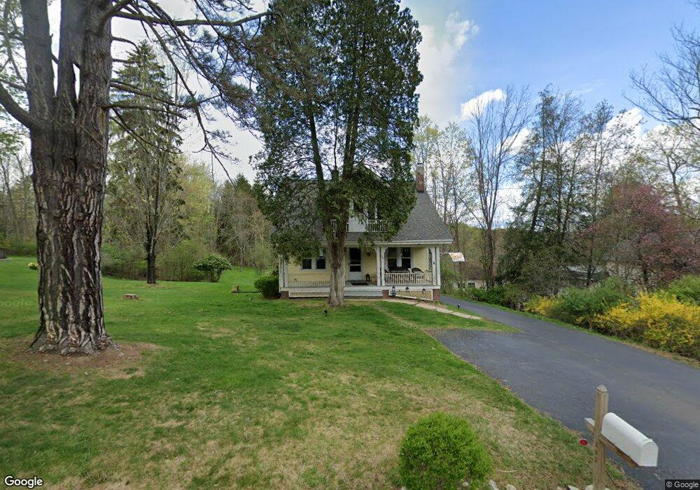
114 Brookside Rd Dalton, PA 18414
Estimated Value: $234,000 - $348,000
3
Beds
2
Baths
2,436
Sq Ft
$118/Sq Ft
Est. Value
About This Home
This home is located at 114 Brookside Rd, Dalton, PA 18414 and is currently estimated at $286,890, approximately $117 per square foot. 114 Brookside Rd is a home located in Lackawanna County with nearby schools including Lackawanna Trail Elementary Center, Lackawanna Trail Junior/Senior High School, and Our Lady Of Peace School.
Ownership History
Date
Name
Owned For
Owner Type
Purchase Details
Closed on
Aug 14, 2019
Sold by
Fuller Lois and Estate Of Dorothea C Metz
Bought by
Loughney Keith R and Reid Brad W
Current Estimated Value
Home Financials for this Owner
Home Financials are based on the most recent Mortgage that was taken out on this home.
Original Mortgage
$132,050
Outstanding Balance
$115,888
Interest Rate
3.8%
Mortgage Type
New Conventional
Estimated Equity
$171,002
Purchase Details
Closed on
Nov 22, 1974
Bought by
Metz Charles and Metz Dorothea
Create a Home Valuation Report for This Property
The Home Valuation Report is an in-depth analysis detailing your home's value as well as a comparison with similar homes in the area
Home Values in the Area
Average Home Value in this Area
Purchase History
| Date | Buyer | Sale Price | Title Company |
|---|---|---|---|
| Loughney Keith R | $110,000 | Lafayette Settlement Svcs | |
| Metz Charles | $4,500 | -- |
Source: Public Records
Mortgage History
| Date | Status | Borrower | Loan Amount |
|---|---|---|---|
| Open | Loughney Keith R | $132,050 |
Source: Public Records
Tax History
| Year | Tax Paid | Tax Assessment Tax Assessment Total Assessment is a certain percentage of the fair market value that is determined by local assessors to be the total taxable value of land and additions on the property. | Land | Improvement |
|---|---|---|---|---|
| 2025 | $3,482 | $10,571 | $1,271 | $9,300 |
| 2024 | $3,005 | $10,571 | $1,271 | $9,300 |
| 2023 | $3,005 | $10,571 | $1,271 | $9,300 |
| 2022 | $2,779 | $10,571 | $1,271 | $9,300 |
| 2021 | $2,743 | $10,571 | $1,271 | $9,300 |
| 2020 | $2,705 | $10,571 | $1,271 | $9,300 |
| 2019 | $2,619 | $10,571 | $1,271 | $9,300 |
| 2018 | $2,585 | $10,571 | $1,271 | $9,300 |
| 2017 | $2,539 | $10,571 | $1,271 | $9,300 |
| 2016 | $607 | $10,571 | $1,271 | $9,300 |
| 2015 | -- | $10,571 | $1,271 | $9,300 |
| 2014 | -- | $10,571 | $1,271 | $9,300 |
Source: Public Records
Map
Nearby Homes
- 0 Sr 4014 Unit GSBSC3273
- 220 Fuller Rd
- 2037 Sr4016
- 107 Garney St
- 302 Weatherby St
- 1-2-3-4 Weatherby St
- 1015 Woodwind Hill Dr
- 62 Timber Trail
- 413 E Main St
- 144 Old Loggers Rd
- 3 Lily Lake Rd
- 4 Lily Lake Rd
- 1796 Lithia Valley Rd
- 460 Newcomb Rd
- 49 College Ave
- 1 Capwell Ave
- 98 College Ave
- 28 Church Hill Rd
- 141 College Ave
- 0 Clinton St Unit GSB234605
- 116 Brookside Rd
- 113 Brookside Rd
- 110 Brookside Rd
- 304 Brookside Rd
- 118 Brookside Rd
- 111 Brookside Rd
- 120 Brookside Rd
- 314 Brookside Rd
- 122 Brookside Rd
- 106 Brookside Rd
- 107 Brookside Rd
- 402 Brookside Rd
- 311 Brookside Rd
- 206 Brookside Rd
- 103 Brookside Rd
- 100 Cherry St
- 410 Brookside Rd
- 412 Brookside Rd
- 104 Cherry St
- 416 Brookside Rd
Your Personal Tour Guide
Ask me questions while you tour the home.