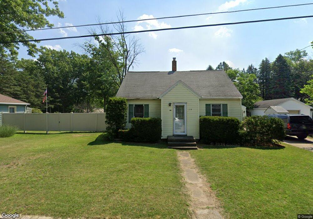
114 Burnside Ct Michigan City, IN 46360
Estimated Value: $129,000 - $181,000
3
Beds
2
Baths
1,592
Sq Ft
$100/Sq Ft
Est. Value
About This Home
This home is located at 114 Burnside Ct, Michigan City, IN 46360 and is currently estimated at $158,613, approximately $99 per square foot. 114 Burnside Ct is a home located in LaPorte County with nearby schools including Joy Elementary School, Martin T. Krueger Middle School, and Michigan City High School.
Ownership History
Date
Name
Owned For
Owner Type
Purchase Details
Closed on
Oct 2, 2024
Sold by
Hartman Mike
Bought by
Hartman Michael
Current Estimated Value
Purchase Details
Closed on
Aug 30, 2024
Sold by
Livinghouse Randy A
Bought by
Hartman Mike
Purchase Details
Closed on
Nov 24, 2014
Sold by
Mayer Dana L and Lykins Dana L
Bought by
Livinghouse Randy A
Home Financials for this Owner
Home Financials are based on the most recent Mortgage that was taken out on this home.
Original Mortgage
$71,677
Interest Rate
4.1%
Mortgage Type
FHA
Create a Home Valuation Report for This Property
The Home Valuation Report is an in-depth analysis detailing your home's value as well as a comparison with similar homes in the area
Home Values in the Area
Average Home Value in this Area
Purchase History
| Date | Buyer | Sale Price | Title Company |
|---|---|---|---|
| Hartman Michael | -- | None Listed On Document | |
| Hartman Mike | -- | None Listed On Document | |
| Livinghouse Randy A | -- | None Available |
Source: Public Records
Mortgage History
| Date | Status | Borrower | Loan Amount |
|---|---|---|---|
| Previous Owner | Livinghouse Randy A | $71,677 |
Source: Public Records
Tax History Compared to Growth
Tax History
| Year | Tax Paid | Tax Assessment Tax Assessment Total Assessment is a certain percentage of the fair market value that is determined by local assessors to be the total taxable value of land and additions on the property. | Land | Improvement |
|---|---|---|---|---|
| 2024 | $705 | $70,700 | $12,200 | $58,500 |
| 2022 | $936 | $72,400 | $12,200 | $60,200 |
| 2021 | $936 | $94,300 | $15,000 | $79,300 |
| 2020 | $936 | $94,300 | $15,000 | $79,300 |
| 2019 | $984 | $94,300 | $15,000 | $79,300 |
| 2018 | $985 | $92,300 | $15,000 | $77,300 |
| 2017 | $886 | $82,500 | $9,800 | $72,700 |
| 2016 | $902 | $85,500 | $9,800 | $75,700 |
| 2014 | $832 | $80,600 | $9,800 | $70,800 |
Source: Public Records
Map
Nearby Homes
- 2905 E Michigan Blvd
- 522 Highland Ave
- 526 Davidson Ave
- 537 Walton Ave
- 2102 Plum St
- 2405 Del Plain Ave
- 610 Davidson Ave
- 2321 Greenwood Ave
- 207 Meadowlark Dr
- 616 Grand Ave
- 210 Finch Trail
- 0 S Woodland Ave
- 623 Esther St
- 126 Dewey St
- 516 Ridgeland Ave
- 231 Avondale Ave
- 0 Dewey St
- 0 Butler St
- 105 Starling Dr
- 1617 E Michigan Blvd
- 112 Burnside Ct
- 116 Burnside Ct
- 113 Burnside Ct
- 0 Willow Ct
- 111 Burnside Ct
- 115 Burnside Ct
- 110 Burnside Ct
- 109 Burnside Ct
- 108 Burnside Ct
- 118 Burnside Ct
- 107 Burnside Ct
- 2822 E Michigan Blvd
- 106 Burnside Ct
- 105 Burnside Ct
- 104 Burnside Ct
- 103 Burnside Ct
- 101 Burnside Ct
- 102 Burnside Ct
- 2824 E Michigan Blvd
- 201 N Roeske Ave