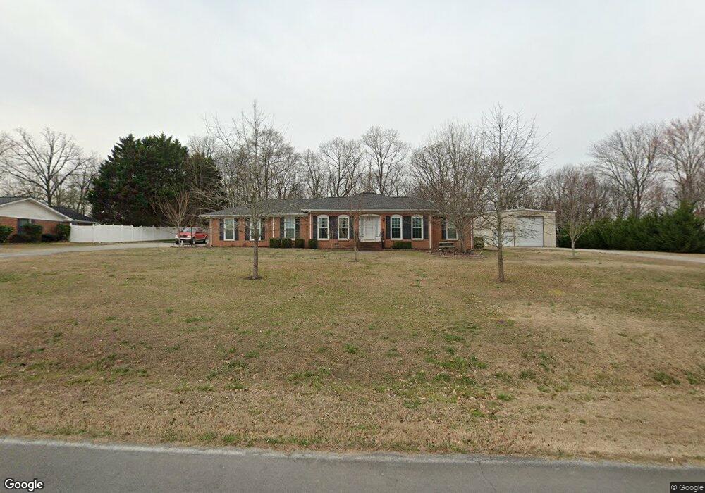
114 Devonwood Dr Calhoun, GA 30701
Estimated Value: $284,724 - $369,000
4
Beds
2
Baths
2,049
Sq Ft
$157/Sq Ft
Est. Value
About This Home
This home is located at 114 Devonwood Dr, Calhoun, GA 30701 and is currently estimated at $321,181, approximately $156 per square foot. 114 Devonwood Dr is a home located in Gordon County with nearby schools including Calhoun Elementary School, Calhoun Middle School, and Calhoun High School.
Ownership History
Date
Name
Owned For
Owner Type
Purchase Details
Closed on
Jun 14, 2016
Sold by
Stokes Pamela
Bought by
Stokes James E and Stokes Pamela
Current Estimated Value
Purchase Details
Closed on
May 2, 2014
Sold by
Bennett Beth Baker
Bought by
Stokes Pamela
Purchase Details
Closed on
May 22, 2002
Sold by
Garner Rex Wallace and Glenda Ha
Bought by
Baker Charles M and Baker Elizabeth M
Purchase Details
Closed on
Jun 14, 2001
Sold by
Eloise Barrett Ryan
Bought by
Garner Rex Wallace and Glenda Hamilto
Create a Home Valuation Report for This Property
The Home Valuation Report is an in-depth analysis detailing your home's value as well as a comparison with similar homes in the area
Purchase History
| Date | Buyer | Sale Price | Title Company |
|---|---|---|---|
| Stokes James E | -- | -- | |
| Stokes Pamela | -- | -- | |
| Stokes Pamela | -- | -- | |
| Baker Charles M | $214,500 | -- | |
| Garner Rex Wallace | $145,000 | -- |
Source: Public Records
Tax History
| Year | Tax Paid | Tax Assessment Tax Assessment Total Assessment is a certain percentage of the fair market value that is determined by local assessors to be the total taxable value of land and additions on the property. | Land | Improvement |
|---|---|---|---|---|
| 2025 | $1,050 | $96,160 | $5,600 | $90,560 |
| 2023 | $964 | $80,240 | $5,600 | $74,640 |
| 2022 | $700 | $75,520 | $5,600 | $69,920 |
| 2021 | $1,170 | $63,520 | $5,600 | $57,920 |
| 2020 | $1,210 | $64,560 | $5,600 | $58,960 |
| 2019 | $1,206 | $64,560 | $5,600 | $58,960 |
| 2018 | $578 | $62,040 | $5,600 | $56,440 |
| 2017 | $580 | $59,000 | $5,600 | $53,400 |
| 2016 | $581 | $59,000 | $5,600 | $53,400 |
| 2015 | $579 | $58,000 | $5,600 | $52,400 |
| 2014 | $533 | $56,686 | $5,600 | $51,086 |
Source: Public Records
Map
Nearby Homes
- 115 Devonwood Dr
- 114 Lindsey Ct NE
- 115 Windsor Dr
- 127 Windsor Dr
- 136 Meadow Ln
- 129 Derby Ln
- 140 Cambridge Ct
- 118 Garden Lake Dr
- 215 NW Briar Ridge Rd
- 103 Mims Dr
- 201 Crestmont Dr
- 121 Hunt Dr
- 123 Waterside Ridge
- 110 Waterside Ridge
- 301 Briarwood Dr
- 326 Curtis Pkwy NE
- 105 Garden Hill Dr
- 622 Pisgah Way
- 301 Windy Hill Dr
- 154 Millers Ln
- 112 Devonwood Dr
- 116 Devonwood Dr
- 111 Devonwood Dr
- 113 Devonwood Dr
- 109 Devonwood Dr
- 110 Devonwood Dr
- 130 Devonwood Dr
- 118 Lindsey Ct NE
- 118 Lindsey Ct NE Unit C51
- 107 Devonwood Dr
- 114 Windsor Dr
- 110 Lindsey Ct NE
- 116 Windsor Dr
- 122 Lindsey Ct NE
- 112 Windsor Dr
- 117 Devonwood Dr
- 153 Barrett Ln
- 108 Devonwood Dr
- 373 Barrett Rd
- 118 Windsor Dr
Your Personal Tour Guide
Ask me questions while you tour the home.