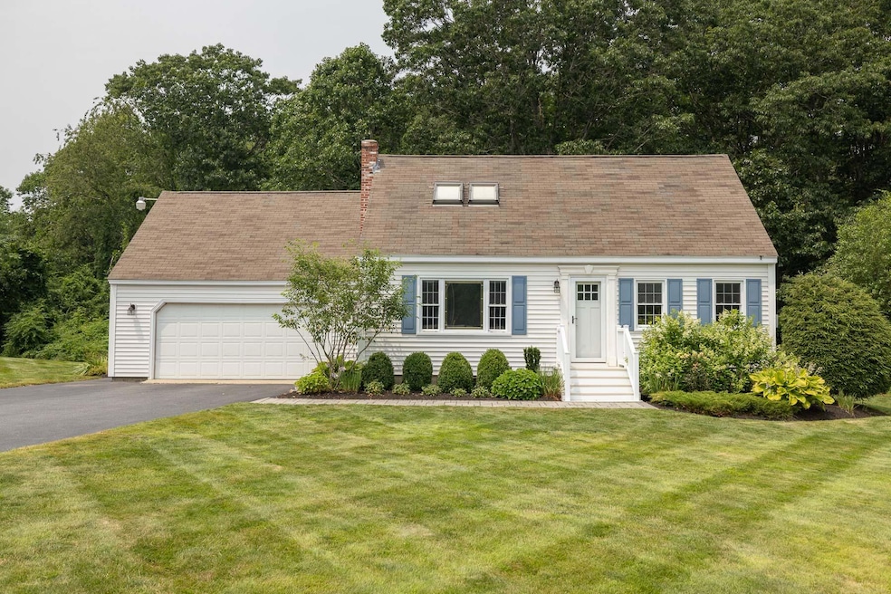
114 Downing Rd Kennebunk, ME 04043
Estimated payment $3,402/month
Highlights
- Public Beach
- View of Trees or Woods
- Deck
- Kennebunk High School Rated 9+
- 3.3 Acre Lot
- Wooded Lot
About This Home
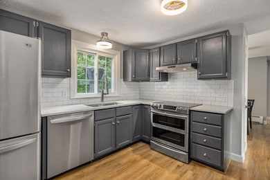
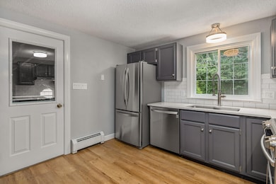
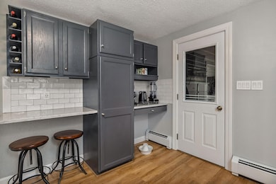
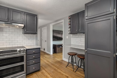
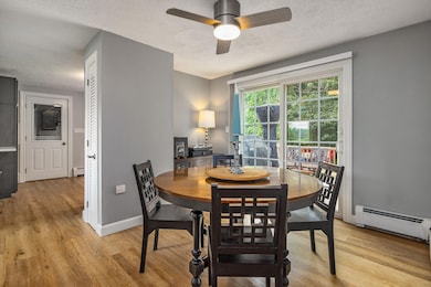
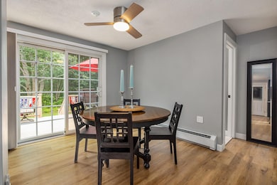
Discover the possibilities at 114 Downing Road: a charming, thoughtfully updated home tucked away on a peaceful and private lot in desirable Kennebunk, Maine. Despite its quiet setting, the location couldn't be more convenient: just 5 minutes to the Maine Turnpike, minutes to local beaches, schools, shopping, and restaurants, 30 minutes to Portland or Portsmouth, and just over an hour to Boston. Inside, enjoy a renovated kitchen and baths, durable and quiet waterproof LVP flooring, updated lighting, first floor bedroom and a basement wood stove that provides gentle warmth on snowy winter days. Step outside to a new composite deck (2023), a stone walkway, and irrigated front gardens that make outdoor living easy and enjoyable. Recent 2025 improvements include a new garage door and opener, keypad entry, and a whole-home water filtration system. What truly sets this property apart is its versatility. Keep the home as is, expand, or use the existing concept plans (provided with the sale) as inspiration to transform it into a guest cottage or ADU while building your dream home farther back on the lot. Few properties allow this level of flexibility in such a prime location. Lovingly owned by the same family for over 20 years, 114 Downing Road is ready to welcome its next chapter - and its next memories. Open House 11/29/2025 11:00 AM - 02:00 PM & 11/30/2025 1-3 PM
Listing Agent
Coldwell Banker Realty Brokerage Phone: 207-967-9900 Listed on: 11/22/2025

Open House Schedule
-
Saturday, November 29, 202511:00 am to 2:00 pm11/29/2025 11:00:00 AM +00:0011/29/2025 2:00:00 PM +00:00Add to Calendar
-
Sunday, November 30, 20251:00 to 3:00 pm11/30/2025 1:00:00 PM +00:0011/30/2025 3:00:00 PM +00:00Add to Calendar
Home Details
Home Type
- Single Family
Est. Annual Taxes
- $4,586
Year Built
- Built in 1974
Lot Details
- 3.3 Acre Lot
- Public Beach
- Rural Setting
- Landscaped
- Level Lot
- Open Lot
- Wooded Lot
- Property is zoned RC
Parking
- 2 Car Attached Garage
Home Design
- Wood Frame Construction
- Shingle Roof
- Vinyl Siding
Interior Spaces
- 1,344 Sq Ft Home
- Ceiling Fan
- Double Pane Windows
- Views of Woods
- Unfinished Basement
- Basement Fills Entire Space Under The House
Kitchen
- Electric Range
- Dishwasher
Flooring
- Heavy Duty
- Tile
Bedrooms and Bathrooms
- 3 Bedrooms
- Main Floor Bedroom
- Walk-In Closet
- 2 Full Bathrooms
- Bathtub
Laundry
- Dryer
- Washer
Utilities
- Cooling Available
- Baseboard Heating
- Hot Water Heating System
- Private Water Source
- Well
- Internet Available
Additional Features
- Deck
- Property is near a golf course
Community Details
- No Home Owners Association
Listing and Financial Details
- Tax Lot 038
- Assessor Parcel Number KENB-000030-000000-000038
Map
Home Values in the Area
Average Home Value in this Area
Tax History
| Year | Tax Paid | Tax Assessment Tax Assessment Total Assessment is a certain percentage of the fair market value that is determined by local assessors to be the total taxable value of land and additions on the property. | Land | Improvement |
|---|---|---|---|---|
| 2024 | $4,117 | $242,900 | $91,000 | $151,900 |
| 2023 | $3,899 | $242,900 | $91,000 | $151,900 |
| 2022 | $3,546 | $242,900 | $91,000 | $151,900 |
| 2021 | $3,461 | $242,900 | $91,000 | $151,900 |
| 2020 | $3,437 | $242,900 | $91,000 | $151,900 |
| 2019 | $3,340 | $242,900 | $91,000 | $151,900 |
| 2018 | $3,187 | $182,100 | $68,200 | $113,900 |
| 2017 | $3,014 | $182,100 | $68,200 | $113,900 |
| 2016 | $2,895 | $182,100 | $68,200 | $113,900 |
| 2015 | $2,786 | $182,100 | $68,200 | $113,900 |
| 2014 | $2,713 | $182,100 | $68,200 | $113,900 |
Purchase History
| Date | Type | Sale Price | Title Company |
|---|---|---|---|
| Warranty Deed | -- | -- | |
| Warranty Deed | -- | -- |
Mortgage History
| Date | Status | Loan Amount | Loan Type |
|---|---|---|---|
| Open | $299,000 | Purchase Money Mortgage | |
| Previous Owner | $85,000 | Purchase Money Mortgage |
Source: Maine Listings
MLS Number: 1644190
APN: KENB-000030-000000-000038
Disclaimer: Certain information contained herein is derived from information provided by parties other than Homes.com. All information provided is deemed reliable, but is not guaranteed to be accurate and should be independently verified.
![]() Listing data is derived in whole or in part from Maine Real Estate Information System, Inc. (d/b/a Maine Listings) and is for consumers' personal, noncommercial use only. Dimensions are approximate and not guaranteed. All data should be independently verified.
Listing data is derived in whole or in part from Maine Real Estate Information System, Inc. (d/b/a Maine Listings) and is for consumers' personal, noncommercial use only. Dimensions are approximate and not guaranteed. All data should be independently verified.
© 2025 Maine Real Estate Information System, Inc. All Rights Reserved. Equal Housing Opportunity.
Homes.com, LLC, 17600 Laguna Canyon Rd Irvine, CA 92618 (888)-952-6393
![]()
- 20 Bow St Unit Duplex
- 5 Oceanview Rd
- 8 Eddy Ave
- 107 May St Unit 107 May St Apt 2
- 8 Raymond St Unit 201
- 110 Graham St Unit 110GrahamStreet2ndfl
- 241 Alfred St Unit 10
- 94 Graham St Unit 301
- 13 Atlantic Ave Unit 2
- 264 Elm St Unit 1
- 264 Elm St Unit 1
- 11 Folsom Dr Unit 11 Folsom Drive
- 484 Main St Unit 101 PrivateEntrance
- 111 Summer St Unit 3
- 41 Crescent St Unit 41 Crescent st unit 2
- 20 Crescent St Unit 2
- 181 Elm St Unit 102
- 1 Summer St
- 53 Beach Ave
- 87 Pool St Unit 301