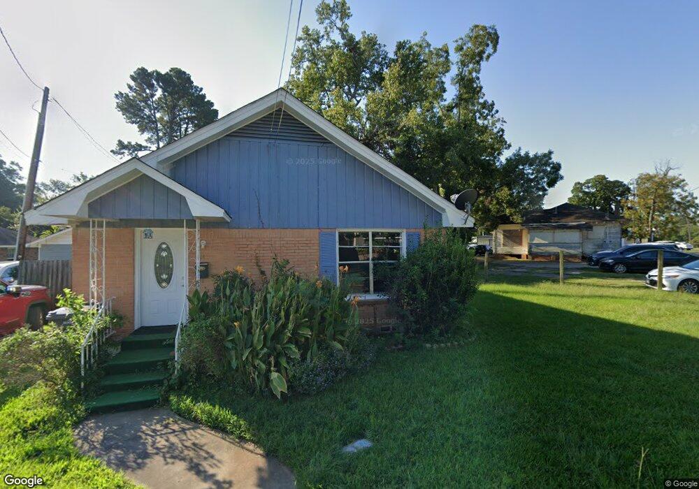
114 E Jodie Ave Lufkin, TX 75901
Estimated Value: $63,000 - $140,000
2
Beds
1
Bath
1,040
Sq Ft
$105/Sq Ft
Est. Value
About This Home
This home is located at 114 E Jodie Ave, Lufkin, TX 75901 and is currently estimated at $109,493, approximately $105 per square foot. 114 E Jodie Ave is a home located in Angelina County with nearby schools including Kurth Primary School, Anderson Elementary School, and Lufkin Middle School.
Ownership History
Date
Name
Owned For
Owner Type
Purchase Details
Closed on
May 1, 2021
Sold by
Alamo Max
Bought by
Diaz Maria E
Current Estimated Value
Home Financials for this Owner
Home Financials are based on the most recent Mortgage that was taken out on this home.
Original Mortgage
$44,561
Outstanding Balance
$40,297
Interest Rate
3.1%
Mortgage Type
Future Advance Clause Open End Mortgage
Estimated Equity
$69,196
Purchase Details
Closed on
Jun 9, 2006
Sold by
Alamo Maximo F
Bought by
Alamo Manuel T
Create a Home Valuation Report for This Property
The Home Valuation Report is an in-depth analysis detailing your home's value as well as a comparison with similar homes in the area
Purchase History
| Date | Buyer | Sale Price | Title Company |
|---|---|---|---|
| Diaz Maria E | -- | None Available | |
| Alamo Manuel T | -- | None Available |
Source: Public Records
Mortgage History
| Date | Status | Borrower | Loan Amount |
|---|---|---|---|
| Open | Diaz Maria E | $44,561 |
Source: Public Records
Tax History
| Year | Tax Paid | Tax Assessment Tax Assessment Total Assessment is a certain percentage of the fair market value that is determined by local assessors to be the total taxable value of land and additions on the property. | Land | Improvement |
|---|---|---|---|---|
| 2025 | $1,175 | $57,360 | $11,680 | $45,680 |
| 2024 | $1,068 | $56,120 | $11,680 | $44,440 |
| 2023 | $924 | $55,280 | $11,680 | $43,600 |
| 2022 | $962 | $51,170 | $6,320 | $44,850 |
| 2021 | $946 | $38,410 | $6,320 | $32,090 |
| 2020 | $860 | $35,010 | $6,320 | $28,690 |
| 2019 | $910 | $35,010 | $6,320 | $28,690 |
| 2018 | $952 | $33,930 | $6,320 | $27,610 |
| 2017 | $952 | $39,920 | $6,320 | $33,600 |
| 2016 | $936 | $39,280 | $6,320 | $32,960 |
| 2015 | -- | $39,280 | $6,320 | $32,960 |
| 2014 | -- | $38,910 | $6,320 | $32,590 |
Source: Public Records
Map
Nearby Homes
- 107 W Kerr Ave
- 5700 Fm 2497
- Tract 189 Hwy 69n
- 6303 Fm 326
- 1417 Fm 706s
- 10111 Hwy 94w
- Lot 2 Fm 326
- Lot 1A Fm 326
- R99018 & 139721 Loop
- 128 Stoney Ridge
- R33846 Hwy 103e
- 3295 Fm 2108
- 4421 Farm-To-market
- 322 Montrose St
- 211 House St
- Lot #1 Fm 706s
- 113 W Menefee St
- 421 House St
- 402 S Bynum St
- 230 Stoney Ridge
- 118 E Jodie Ave
- 115A E Denman Ave Unit 115B
- 119 E Denman Ave
- 125 E Denman Ave
- 122 E Jodie Ave
- 120
- 120
- 514 S 2nd St
- 135 E Denman Ave
- 102 E Denman Ave
- 2 E Denman Ave
- 515 S First St
- 120 E Denman Ave Unit 4
- 120 E Denman Ave Unit 3
- 120 E Denman Ave Unit 2
- 120 E Denman Ave Unit 1
- 120 E Denman Ave Unit 5
- 120 E Denman Ave
- 602 S 1st St
- 511 S 1st St
Your Personal Tour Guide
Ask me questions while you tour the home.