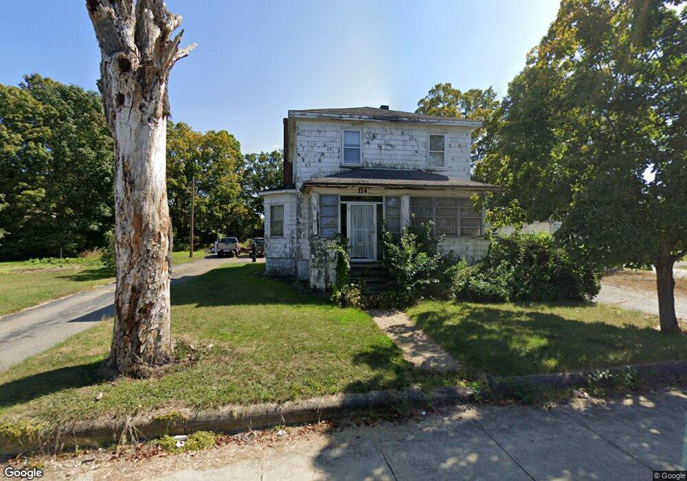
114 Linden St Taunton, MA 02780
Weir Village NeighborhoodEstimated Value: $458,501 - $493,000
4
Beds
2
Baths
1,714
Sq Ft
$278/Sq Ft
Est. Value
About This Home
This home is located at 114 Linden St, Taunton, MA 02780 and is currently estimated at $476,375, approximately $277 per square foot. 114 Linden St is a home located in Bristol County with nearby schools including East Taunton Elementary School, Taunton High School, and Our Lady of Lourdes School.
Ownership History
Date
Name
Owned For
Owner Type
Purchase Details
Closed on
Sep 29, 2025
Sold by
114 Linden St T and Caverly
Bought by
Caverly Family Linden Nt and Caverly
Current Estimated Value
Purchase Details
Closed on
Sep 26, 2025
Sold by
Caverly Lois A and Garda Thomas P
Bought by
Caverly Family Linden Nt and Caverly
Purchase Details
Closed on
Jul 24, 2009
Sold by
Victoria M Garda Ret and Garda
Bought by
114 Linden Street T and 114 Garda
Create a Home Valuation Report for This Property
The Home Valuation Report is an in-depth analysis detailing your home's value as well as a comparison with similar homes in the area
Home Values in the Area
Average Home Value in this Area
Purchase History
| Date | Buyer | Sale Price | Title Company |
|---|---|---|---|
| Caverly Family Linden Nt | -- | -- | |
| Garda Raymond L Est | -- | -- | |
| Caverly Family Linden Nt | -- | -- | |
| Caverly Lois A | -- | -- | |
| Garda Raymond L Est | -- | -- | |
| 114 Linden Street T | -- | -- | |
| 114 Linden Street T | -- | -- |
Source: Public Records
Tax History Compared to Growth
Tax History
| Year | Tax Paid | Tax Assessment Tax Assessment Total Assessment is a certain percentage of the fair market value that is determined by local assessors to be the total taxable value of land and additions on the property. | Land | Improvement |
|---|---|---|---|---|
| 2025 | $3,694 | $337,700 | $127,300 | $210,400 |
| 2024 | $3,864 | $345,300 | $127,300 | $218,000 |
| 2023 | $3,822 | $317,200 | $127,300 | $189,900 |
| 2022 | $3,638 | $276,000 | $106,100 | $169,900 |
| 2021 | $3,496 | $246,200 | $96,400 | $149,800 |
| 2020 | $3,381 | $227,500 | $96,400 | $131,100 |
| 2019 | $3,270 | $207,500 | $96,400 | $111,100 |
| 2018 | $3,229 | $205,400 | $97,400 | $108,000 |
| 2017 | $2,947 | $187,600 | $92,300 | $95,300 |
| 2016 | $2,887 | $184,100 | $89,600 | $94,500 |
| 2015 | $2,828 | $188,400 | $91,100 | $97,300 |
| 2014 | $2,773 | $189,800 | $91,100 | $98,700 |
Source: Public Records
Map
Nearby Homes
- 1 Fayal Ave
- 29 Williams Ave
- 71 Linden St
- 41 Hart Ave
- 8 Herbert St
- 1301 Carriage Ln Unit 1301
- 11 Talbot Ave
- 25 Johnson St Unit B
- 23 Johnson St Unit C
- 600 County St
- 600 County St Lot A
- 600
- 3 Karena Dr Unit 8
- 195 Pratt St Unit A
- 6 Southeast St
- 70 Landing Dr Unit 5-L
- 90 E Water St
- 170 Hart St Unit B
- 11 Williams St
- 24 1st St
- 61c Hart St
- 61c Hart St Unit C
- 61B Hart St
- 61B Hart St Unit B
- 61A Hart St Unit A
- 61A Hart St
- 115 Linden St Unit 2L
- 115 Linden St Unit 2
- 115 Linden St Unit 1
- 61 Hart St
- 61 Hart St Unit B
- 61 Hart St Unit C
- 110 Linden St
- 59 Hart St
- 76 Hart St
- 76 Hart St Unit B
- 76A Hart St
- 76 Hart St
- 0 Columbus Blvd
- 111 Linden St