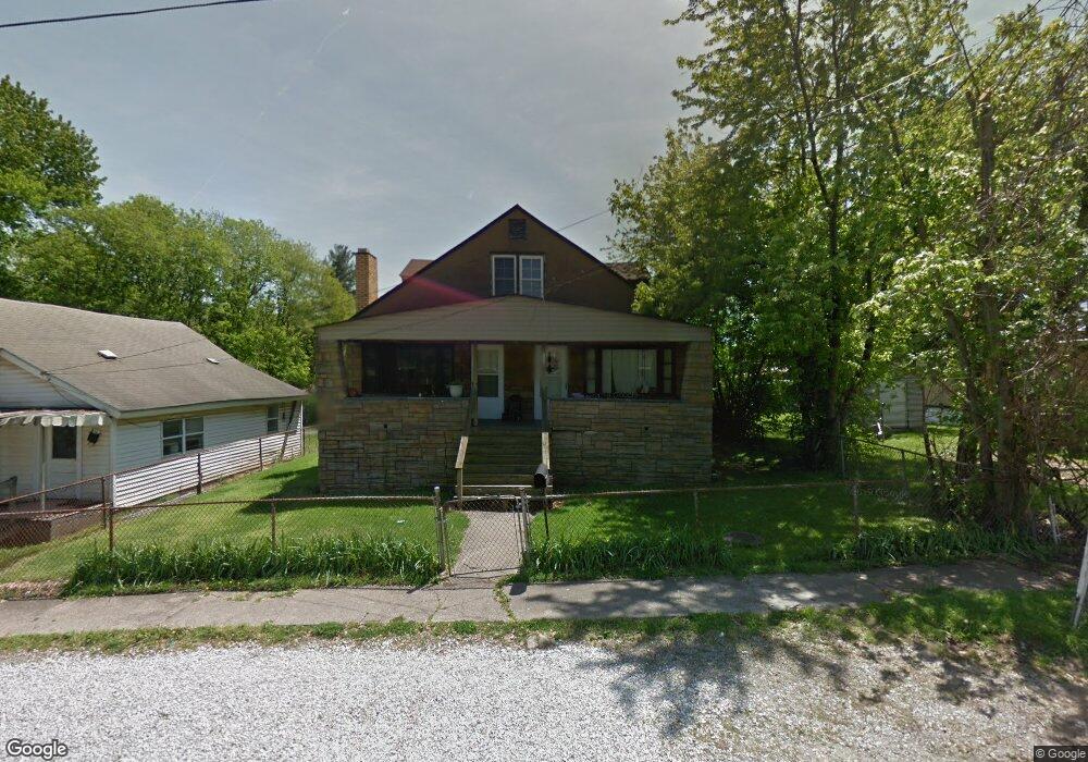
114 Main St Coal Grove, OH 45638
Estimated Value: $84,000 - $215,000
4
Beds
2
Baths
2,256
Sq Ft
$65/Sq Ft
Est. Value
About This Home
This home is located at 114 Main St, Coal Grove, OH 45638 and is currently estimated at $146,396, approximately $64 per square foot. 114 Main St is a home located in Lawrence County with nearby schools including Dawson-Bryant Elementary School, Dawson-Bryant Middle School, and Dawson-Bryant High School.
Ownership History
Date
Name
Owned For
Owner Type
Purchase Details
Closed on
Jan 12, 2004
Sold by
Black Emma
Bought by
Wise Randall E and Wise Diana
Current Estimated Value
Purchase Details
Closed on
Sep 25, 2003
Sold by
Black Clifford L
Bought by
Black Emma
Purchase Details
Closed on
Mar 9, 2001
Bought by
Black Clifford L
Purchase Details
Closed on
Nov 22, 2000
Sold by
Brown David Franklin
Bought by
Norwest Financial Kentuck
Purchase Details
Closed on
Jul 28, 1992
Sold by
Brown Timothy Ray and Brown Dean
Bought by
Brown David Franklin
Create a Home Valuation Report for This Property
The Home Valuation Report is an in-depth analysis detailing your home's value as well as a comparison with similar homes in the area
Home Values in the Area
Average Home Value in this Area
Purchase History
| Date | Buyer | Sale Price | Title Company |
|---|---|---|---|
| Wise Randall E | $15,000 | -- | |
| Black Emma | -- | -- | |
| Black Clifford L | $3,300 | -- | |
| Norwest Financial Kentuck | -- | -- | |
| Brown David Franklin | $24,400 | -- |
Source: Public Records
Tax History
| Year | Tax Paid | Tax Assessment Tax Assessment Total Assessment is a certain percentage of the fair market value that is determined by local assessors to be the total taxable value of land and additions on the property. | Land | Improvement |
|---|---|---|---|---|
| 2025 | $823 | $24,700 | $4,921 | $19,779 |
| 2024 | -- | $24,250 | $4,470 | $19,780 |
| 2023 | $823 | $24,250 | $4,470 | $19,780 |
| 2022 | $820 | $24,250 | $4,470 | $19,780 |
| 2021 | $647 | $21,260 | $4,150 | $17,110 |
| 2020 | $748 | $21,260 | $4,150 | $17,110 |
| 2019 | $746 | $21,260 | $4,150 | $17,110 |
| 2018 | $754 | $21,260 | $4,150 | $17,110 |
| 2017 | $752 | $21,260 | $4,150 | $17,110 |
| 2016 | $704 | $21,260 | $4,150 | $17,110 |
| 2015 | $713 | $20,020 | $4,150 | $15,870 |
| 2014 | $666 | $20,020 | $4,150 | $15,870 |
| 2013 | $665 | $20,020 | $4,150 | $15,870 |
Source: Public Records
Map
Nearby Homes
- 222 Saint Charles St
- 303 Pike St
- 805 1/2 High St
- 514 Lane St
- 519 Lane St
- 103 Carrico Dr
- 0 Central & Mlk
- 1100 Price St
- 1003 Marion Pike
- 2805 S 8th St
- 1400 Montgomery Ave
- 508 16th St
- 115 Patton Dr
- 212 Bellefonte Princess Rd
- 1824 Carter Ave
- 0 18th Street & Central Ave
- 601 Pollard Rd
- 298 Bellefonte Princess Rd
- 107 Patton Dr
- 0 Pollard Rd
Your Personal Tour Guide
Ask me questions while you tour the home.