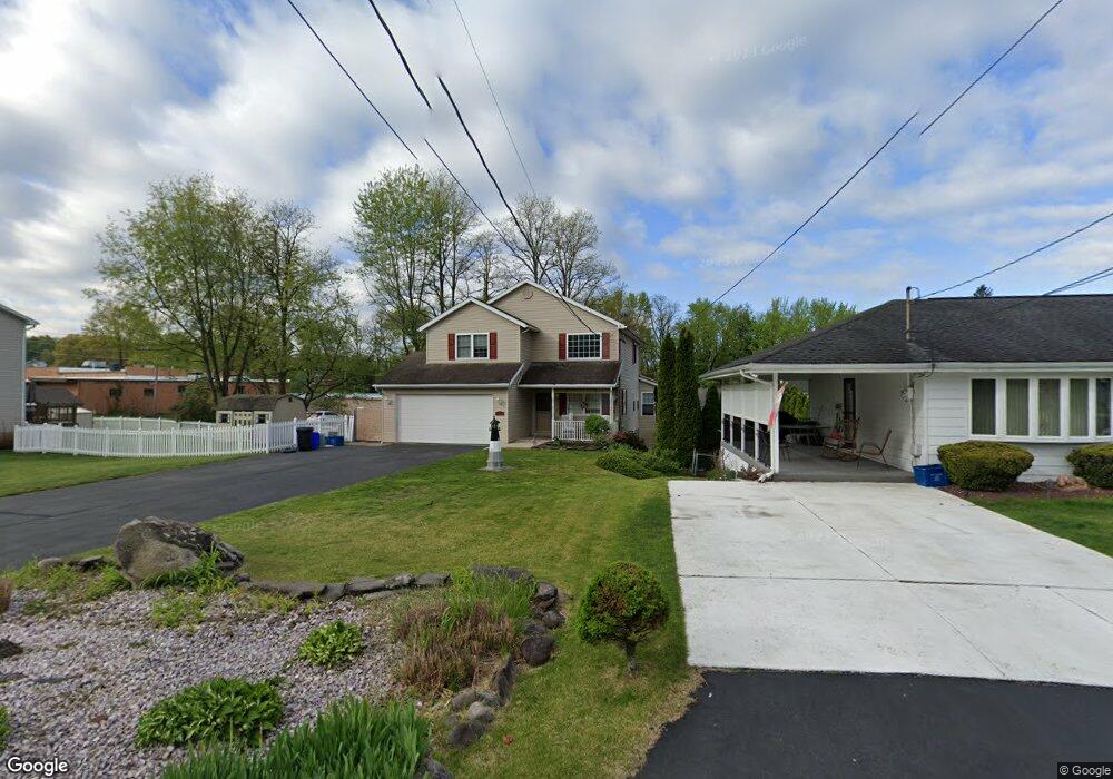
114 Maple Ln Pittston, PA 18640
Estimated Value: $336,000 - $392,000
3
Beds
4
Baths
2,079
Sq Ft
$173/Sq Ft
Est. Value
About This Home
This home is located at 114 Maple Ln, Pittston, PA 18640 and is currently estimated at $359,090, approximately $172 per square foot. 114 Maple Ln is a home located in Luzerne County with nearby schools including Pittston City Intermediate Center, Pittston Area Middle School, and Pittston Area Senior High School.
Ownership History
Date
Name
Owned For
Owner Type
Purchase Details
Closed on
Aug 5, 2020
Sold by
Desalvo Samuel J and Desalvo Carol
Bought by
Melley Andie N and Cristiano Daniel
Current Estimated Value
Home Financials for this Owner
Home Financials are based on the most recent Mortgage that was taken out on this home.
Original Mortgage
$232,707
Outstanding Balance
$204,091
Interest Rate
3%
Mortgage Type
FHA
Estimated Equity
$154,999
Purchase Details
Closed on
Aug 27, 2019
Sold by
Desalvo Samuel J
Bought by
Desalvo Samuel J and Desalvo Carol
Purchase Details
Closed on
Jan 5, 2012
Sold by
Miller Robert E and Miller Lois A
Bought by
Desalvo Samuel A and Desalvo Mildred A
Home Financials for this Owner
Home Financials are based on the most recent Mortgage that was taken out on this home.
Original Mortgage
$140,000
Interest Rate
4%
Mortgage Type
New Conventional
Create a Home Valuation Report for This Property
The Home Valuation Report is an in-depth analysis detailing your home's value as well as a comparison with similar homes in the area
Home Values in the Area
Average Home Value in this Area
Purchase History
| Date | Buyer | Sale Price | Title Company |
|---|---|---|---|
| Melley Andie N | $237,000 | Keystone Premier Setmnt Svcs | |
| Desalvo Samuel J | -- | None Available | |
| Desalvo Samuel J | -- | None Available | |
| Desalvo Samuel A | $200,000 | None Available |
Source: Public Records
Mortgage History
| Date | Status | Borrower | Loan Amount |
|---|---|---|---|
| Open | Melley Andie N | $232,707 | |
| Previous Owner | Desalvo Samuel A | $140,000 |
Source: Public Records
Tax History
| Year | Tax Paid | Tax Assessment Tax Assessment Total Assessment is a certain percentage of the fair market value that is determined by local assessors to be the total taxable value of land and additions on the property. | Land | Improvement |
|---|---|---|---|---|
| 2026 | $4,824 | $190,000 | $22,200 | $167,800 |
| 2025 | $4,806 | $190,000 | $22,200 | $167,800 |
| 2024 | $4,806 | $190,000 | $22,200 | $167,800 |
| 2023 | $4,806 | $190,000 | $22,200 | $167,800 |
| 2022 | $4,771 | $190,000 | $22,200 | $167,800 |
| 2021 | $4,676 | $190,000 | $22,200 | $167,800 |
| 2020 | $4,570 | $190,000 | $22,200 | $167,800 |
| 2019 | $4,533 | $190,000 | $22,200 | $167,800 |
| 2018 | $4,388 | $190,000 | $22,200 | $167,800 |
| 2017 | $4,291 | $190,000 | $22,200 | $167,800 |
| 2016 | -- | $190,000 | $22,200 | $167,800 |
| 2015 | $3,599 | $190,000 | $22,200 | $167,800 |
| 2014 | $3,599 | $190,000 | $22,200 | $167,800 |
Source: Public Records
Map
Nearby Homes
- 11 Joshua Ln
- 41 Drummond St
- 15 Huckleberry Ln
- 578 N Main St
- Lot 32 Cremard Blvd
- 93 1/2 Carroll St
- 422 Rockledge Dr
- 420 Rockledge Dr
- 17 Sand St
- 174 Evans St
- 31 Exeter Ave
- 333 Stanton St
- 125 Mcalpine St
- 0 Exeter Ave
- 114 Chittenden St
- 424 New St
- 613 William St
- 8 Montgomery Ave
- 707 Exeter Ave
- 220 Montgomery Ave
Your Personal Tour Guide
Ask me questions while you tour the home.