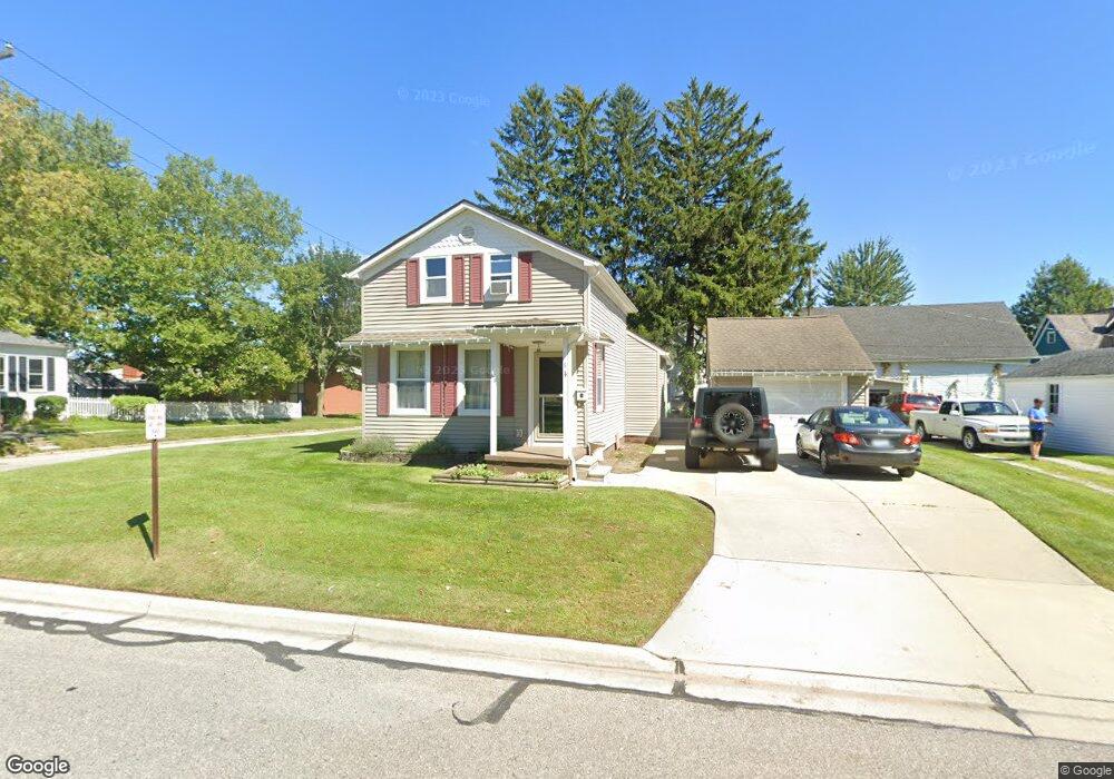
114 N 6th St Saint Clair, MI 48079
Estimated Value: $168,000 - $234,000
3
Beds
2
Baths
1,165
Sq Ft
$162/Sq Ft
Est. Value
About This Home
This home is located at 114 N 6th St, Saint Clair, MI 48079 and is currently estimated at $189,239, approximately $162 per square foot. 114 N 6th St is a home located in St. Clair County with nearby schools including Pine River Elementary School, St. Clair Middle School, and St. Clair High School.
Ownership History
Date
Name
Owned For
Owner Type
Purchase Details
Closed on
Nov 4, 2008
Sold by
Deutsche Bank National Trust Company
Bought by
Henson Desiree
Current Estimated Value
Home Financials for this Owner
Home Financials are based on the most recent Mortgage that was taken out on this home.
Original Mortgage
$67,467
Outstanding Balance
$43,259
Interest Rate
5.95%
Mortgage Type
FHA
Estimated Equity
$145,980
Purchase Details
Closed on
May 1, 2008
Sold by
Miller Kristina M
Bought by
Deutsche Bank Trust Company
Create a Home Valuation Report for This Property
The Home Valuation Report is an in-depth analysis detailing your home's value as well as a comparison with similar homes in the area
Home Values in the Area
Average Home Value in this Area
Purchase History
| Date | Buyer | Sale Price | Title Company |
|---|---|---|---|
| Henson Desiree | $68,000 | -- | |
| Deutsche Bank Trust Company | $146,106 | None Available |
Source: Public Records
Mortgage History
| Date | Status | Borrower | Loan Amount |
|---|---|---|---|
| Open | Henson Desiree | $67,467 |
Source: Public Records
Tax History
| Year | Tax Paid | Tax Assessment Tax Assessment Total Assessment is a certain percentage of the fair market value that is determined by local assessors to be the total taxable value of land and additions on the property. | Land | Improvement |
|---|---|---|---|---|
| 2025 | $1,442 | $78,000 | $0 | $0 |
| 2024 | $1,403 | $74,200 | $0 | $0 |
| 2023 | $1,316 | $63,600 | $0 | $0 |
| 2022 | $1,448 | $58,700 | $0 | $0 |
| 2020 | $1,369 | $49,600 | $49,600 | $0 |
| 2019 | $1,293 | $44,000 | $0 | $0 |
| 2018 | $1,301 | $39,600 | $0 | $0 |
| 2017 | $1,275 | $37,600 | $0 | $0 |
| 2016 | $1,179 | $37,600 | $0 | $0 |
| 2015 | -- | $33,900 | $33,900 | $0 |
| 2014 | -- | $31,200 | $31,200 | $0 |
| 2013 | -- | $31,200 | $0 | $0 |
Source: Public Records
Map
Nearby Homes
- 516 Adams St Unit Bldg-Unit
- 516 Adams St
- 506 Adams St
- 115 N 5th St
- 105 N 5th St
- 516 Thornapple St
- 105 Fifth
- 216 N 6th St
- 415 Thornapple St
- 414 Adams St
- 414 Thornapple St Unit Bldg-Unit
- 414 Thornapple St
- 515 Adams St
- 410 Adams St
- 505 Adams St Unit Bldg-Unit
- 505 Adams St
- 408 Thornapple St
- 403 Thornapple St
- 214 N 5th St
- 402 Adams St
Your Personal Tour Guide
Ask me questions while you tour the home.