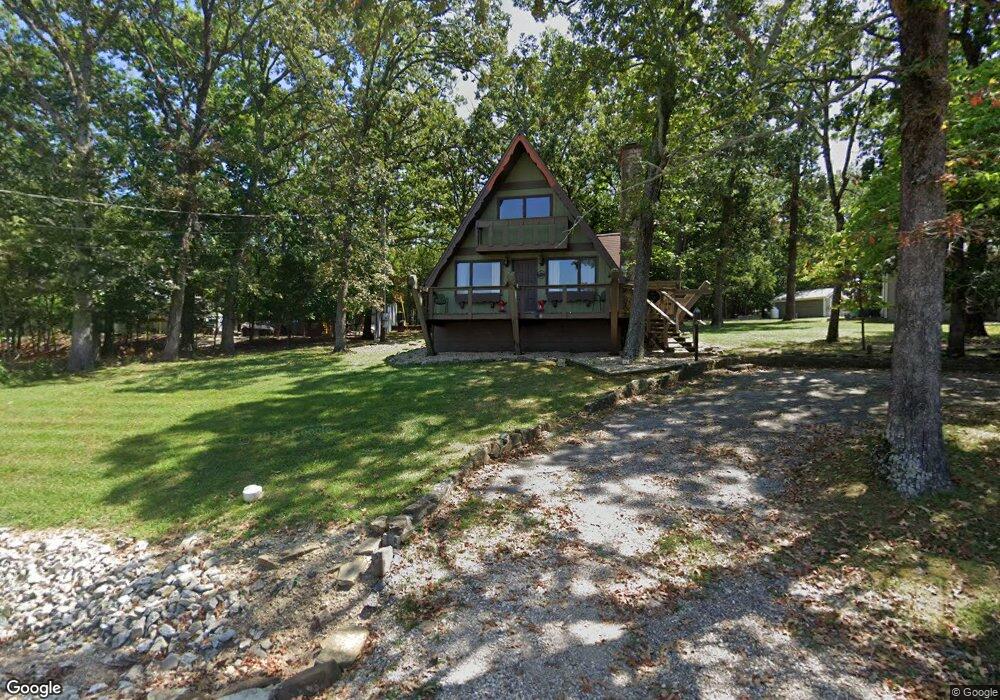
114 N Caps Cove Ln Branson, MO 65616
Estimated Value: $212,245 - $633,000
3
Beds
--
Bath
960
Sq Ft
$426/Sq Ft
Est. Value
About This Home
This home is located at 114 N Caps Cove Ln, Branson, MO 65616 and is currently estimated at $409,061, approximately $426 per square foot. 114 N Caps Cove Ln is a home with nearby schools including Reeds Spring Primary School, Reeds Spring Elementary School, and Reeds Spring Middle School.
Ownership History
Date
Name
Owned For
Owner Type
Purchase Details
Closed on
Apr 25, 2019
Sold by
Schuman Bruce D and Schuman Peggy A
Bought by
Stull Lewis
Current Estimated Value
Home Financials for this Owner
Home Financials are based on the most recent Mortgage that was taken out on this home.
Original Mortgage
$131,572
Outstanding Balance
$116,139
Interest Rate
4.5%
Mortgage Type
FHA
Estimated Equity
$292,923
Purchase Details
Closed on
Apr 11, 2019
Sold by
Mueller Patrick J and Mueller Cindy
Bought by
Schumann Peggy A
Home Financials for this Owner
Home Financials are based on the most recent Mortgage that was taken out on this home.
Original Mortgage
$131,572
Outstanding Balance
$116,139
Interest Rate
4.5%
Mortgage Type
FHA
Estimated Equity
$292,923
Purchase Details
Closed on
Oct 2, 2007
Sold by
Mueller Helen M
Bought by
Hodge Peggy A and Mueller Patrick J
Create a Home Valuation Report for This Property
The Home Valuation Report is an in-depth analysis detailing your home's value as well as a comparison with similar homes in the area
Home Values in the Area
Average Home Value in this Area
Purchase History
| Date | Buyer | Sale Price | Title Company |
|---|---|---|---|
| Stull Lewis | -- | None Available | |
| Schumann Peggy A | -- | None Available | |
| Hodge Peggy A | -- | None Available |
Source: Public Records
Mortgage History
| Date | Status | Borrower | Loan Amount |
|---|---|---|---|
| Open | Stull Lewis | $131,572 |
Source: Public Records
Tax History Compared to Growth
Tax History
| Year | Tax Paid | Tax Assessment Tax Assessment Total Assessment is a certain percentage of the fair market value that is determined by local assessors to be the total taxable value of land and additions on the property. | Land | Improvement |
|---|---|---|---|---|
| 2024 | $726 | $14,840 | -- | -- |
| 2023 | $726 | $14,840 | $0 | $0 |
| 2022 | $722 | $14,840 | $0 | $0 |
| 2021 | $731 | $14,840 | $0 | $0 |
| 2020 | $644 | $14,840 | $0 | $0 |
| 2019 | $640 | $14,840 | $0 | $0 |
| 2018 | $639 | $14,840 | $0 | $0 |
| 2017 | $639 | $14,820 | $0 | $0 |
| 2016 | $622 | $14,820 | $0 | $0 |
| 2015 | $623 | $14,820 | $0 | $0 |
| 2014 | $613 | $14,820 | $0 | $0 |
| 2012 | $614 | $14,820 | $0 | $0 |
Source: Public Records
Map
Nearby Homes
- 410 Tablerock Cir
- 956 Tablerock Cir
- 60 Timber Oaks Trail Unit C
- 49 Timber Trace Ln
- 48 Timber Trace Ln
- 26 Cave Ln Unit Cabin 10
- 70 Dogwood Park Trail Unit 1510
- 168 Jax Trail Unit 49
- 164 Dogwood Park Trail Unit A & B
- 172 Dogwood Park Trail Unit 1110
- 10 View Tablerock Landing
- Lot 47 Dogwood Valley Estates
- 95 Leaning Tree Cir
- 429 Chinquapin Cir Unit 608
- 429 Chinquapin Cir Unit 504
- 429 Chinquapin Cir Unit 607
- 638 Double Day Loop
- 24 Village Trail Unit 7
- 24 Village Trail Unit 13-2
- 24 Village Trail Unit 2
- 74 N Caps Cove Ln
- 123 N Caps Cove Ln
- 103 N Caps Cove Ln
- 137 N Caps Cove Ln
- 89 N Caps Cove Ln
- 141 N Caps Cove Ln
- 81 N Caps Cove Ln
- 0 N Caps Cove Ln
- 71 N Caps Cove Ln
- 44 N Caps Cove Ln
- 240 Tablerock Cir
- 53 N Caps Cove Ln
- 35 N Caps Cove Ln
- 264 Tablerock Cir
- 243 Tablerock Cir
- 21 N Caps Cove Ln
- Lot 33 Tablerock
- 5 S Caps Cove Ln
- 25 S Caps Cove Ln
- 19-A Mayden Dr