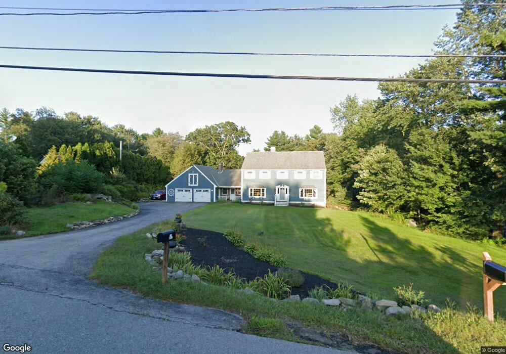
114 Osgood Rd Charlton, MA 01507
Estimated Value: $725,962 - $889,000
4
Beds
3
Baths
3,136
Sq Ft
$259/Sq Ft
Est. Value
About This Home
This home is located at 114 Osgood Rd, Charlton, MA 01507 and is currently estimated at $811,741, approximately $258 per square foot. 114 Osgood Rd is a home located in Worcester County with nearby schools including Shepherd Hill Regional High School.
Ownership History
Date
Name
Owned For
Owner Type
Purchase Details
Closed on
Jan 21, 2025
Sold by
Morey Dana P and Morey Carol A
Bought by
Morey Ft and Morey
Current Estimated Value
Purchase Details
Closed on
Oct 16, 1985
Bought by
Morey Dana R and Morey Carol A
Create a Home Valuation Report for This Property
The Home Valuation Report is an in-depth analysis detailing your home's value as well as a comparison with similar homes in the area
Home Values in the Area
Average Home Value in this Area
Purchase History
| Date | Buyer | Sale Price | Title Company |
|---|---|---|---|
| Morey Ft | -- | None Available | |
| Morey Ft | -- | None Available | |
| Morey Dana R | $23,900 | -- |
Source: Public Records
Mortgage History
| Date | Status | Borrower | Loan Amount |
|---|---|---|---|
| Previous Owner | Morey Dana R | $100,000 | |
| Previous Owner | Morey Dana R | $39,000 | |
| Previous Owner | Morey Dana R | $120,000 |
Source: Public Records
Tax History Compared to Growth
Tax History
| Year | Tax Paid | Tax Assessment Tax Assessment Total Assessment is a certain percentage of the fair market value that is determined by local assessors to be the total taxable value of land and additions on the property. | Land | Improvement |
|---|---|---|---|---|
| 2025 | $6,964 | $625,700 | $146,100 | $479,600 |
| 2024 | $6,750 | $595,200 | $139,900 | $455,300 |
| 2023 | $6,571 | $539,900 | $130,900 | $409,000 |
| 2022 | $6,556 | $493,300 | $107,900 | $385,400 |
| 2021 | $6,986 | $396,000 | $86,900 | $309,100 |
| 2020 | $5,827 | $390,000 | $80,900 | $309,100 |
| 2019 | $5,760 | $390,000 | $80,900 | $309,100 |
| 2018 | $6,307 | $390,000 | $80,900 | $309,100 |
| 2017 | $5,500 | $390,100 | $80,900 | $309,200 |
| 2016 | $5,376 | $390,100 | $80,900 | $309,200 |
| 2015 | $5,235 | $390,100 | $80,900 | $309,200 |
| 2014 | $4,921 | $388,700 | $75,900 | $312,800 |
Source: Public Records
Map
Nearby Homes
- 208 Sunset Dr
- Lot 0 N Sturbridge Rd
- 3 Cranberry Meadow Shore Rd
- 199 Center Depot Rd
- 49 Jennings Rd
- 45 Jennings Rd
- 38 Stevens Park Rd
- 204 Brookfield Rd
- 86 Jolicoeur Ave
- Lot 3 0 N Sullivan Rd
- Lot 6 0 N Sullivan Rd
- Lot 5 0 N Sullivan Rd
- Lot 4 0 N Sullivan Rd
- 216 Brookfield Rd
- 65 Old Spencer Rd
- 38 N Sullivan Rd
- 9 Knollwood Dr
- 7 Little Muggett Rd
- 0 Worcester Rd
- 5 Carpenter Hill Rd
- 116 Osgood Rd
- 112 Osgood Rd
- 120 Osgood Rd
- 106 Osgood Rd
- 109 Osgood Rd
- 100 Osgood Rd
- 119 Osgood Rd
- 113 Osgood Rd
- 126 Osgood Rd
- 145 Glen Echo Shore Rd
- 98 Osgood Rd
- 123 Osgood Rd
- 150 Glen Echo Shore Rd
- 99 Osgood Rd
- 154 Glen Echo Shore Rd
- 139 Glen Echo Shore Rd
- 146 Glen Echo Shore Rd
- 125 Osgood Rd
- 130 Osgood Rd
- 140 Glen Echo Shore Rd