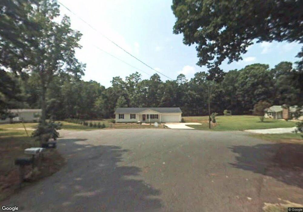
114 Rhonda Rd Central, SC 29630
Estimated Value: $273,000 - $279,445
3
Beds
2
Baths
1,360
Sq Ft
$202/Sq Ft
Est. Value
About This Home
This home is located at 114 Rhonda Rd, Central, SC 29630 and is currently estimated at $275,361, approximately $202 per square foot. 114 Rhonda Rd is a home located in Anderson County with nearby schools including Pendleton High School.
Ownership History
Date
Name
Owned For
Owner Type
Purchase Details
Closed on
Dec 12, 2012
Sold by
Holland Charles E and Holland Kathryn L
Bought by
Sizemore Robert F and Sizemore Susan B
Current Estimated Value
Home Financials for this Owner
Home Financials are based on the most recent Mortgage that was taken out on this home.
Original Mortgage
$125,716
Outstanding Balance
$87,019
Interest Rate
3.35%
Mortgage Type
VA
Estimated Equity
$188,342
Purchase Details
Closed on
Aug 26, 2008
Sold by
Garrison Arthur D and Garrison Leslie M
Bought by
Holland Charles E and Holland Kathryn L
Create a Home Valuation Report for This Property
The Home Valuation Report is an in-depth analysis detailing your home's value as well as a comparison with similar homes in the area
Home Values in the Area
Average Home Value in this Area
Purchase History
| Date | Buyer | Sale Price | Title Company |
|---|---|---|---|
| Sizemore Robert F | $121,700 | -- | |
| Holland Charles E | $125,000 | -- |
Source: Public Records
Mortgage History
| Date | Status | Borrower | Loan Amount |
|---|---|---|---|
| Open | Sizemore Robert F | $125,716 |
Source: Public Records
Tax History Compared to Growth
Tax History
| Year | Tax Paid | Tax Assessment Tax Assessment Total Assessment is a certain percentage of the fair market value that is determined by local assessors to be the total taxable value of land and additions on the property. | Land | Improvement |
|---|---|---|---|---|
| 2024 | $618 | $6,530 | $400 | $6,130 |
| 2023 | $615 | $6,530 | $400 | $6,130 |
| 2022 | $553 | $6,530 | $400 | $6,130 |
| 2021 | $449 | $5,200 | $360 | $4,840 |
| 2020 | $443 | $5,200 | $360 | $4,840 |
| 2019 | $443 | $5,200 | $360 | $4,840 |
| 2018 | $446 | $5,200 | $360 | $4,840 |
| 2017 | -- | $5,200 | $360 | $4,840 |
| 2016 | $419 | $4,850 | $200 | $4,650 |
| 2015 | $422 | $4,850 | $200 | $4,650 |
| 2014 | $436 | $4,850 | $200 | $4,650 |
Source: Public Records
Map
Nearby Homes
- 2923 Old Greenville Hwy
- 2925 Old Greenville Hwy
- 162 Refuge Church Rd
- 530 Porter Rd
- 00 Danenhower Rd
- 241 Founders Blvd
- 327 Grange Valley Ln
- 908 Chester Cir
- 846 Crouch Dr
- 168 Queens Mill Ct
- 156 Queens Mill Ct
- 00 Spake Rd Unit Lot C
- 00 Spake Rd Unit Lot D
- 153 Queens Mill Ct
- 179 Queens Mill Ct
- Stonehaven Plan at The Grange
- Cameron Plan at The Grange
- Kendrick Plan at The Grange
- 205 Howard Ave
- 616 Anderson Rd