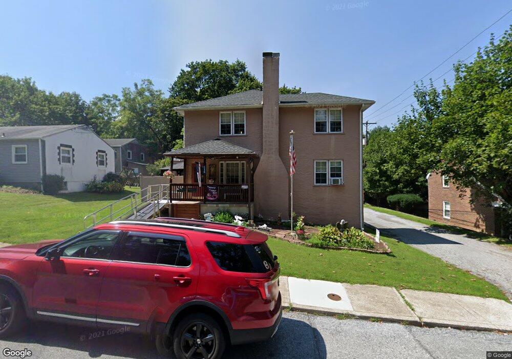
114 S 13th Ave Coatesville, PA 19320
Estimated Value: $303,000 - $480,560
4
Beds
2
Baths
2,398
Sq Ft
$154/Sq Ft
Est. Value
About This Home
This home is located at 114 S 13th Ave, Coatesville, PA 19320 and is currently estimated at $369,853, approximately $154 per square foot. 114 S 13th Ave is a home located in Chester County with nearby schools including Caln Elementary School, Coatesville Intermediate High School, and Coatesville Area Senior High School.
Ownership History
Date
Name
Owned For
Owner Type
Purchase Details
Closed on
Jul 27, 1998
Sold by
Roop Dewey and Roop Dorothy
Bought by
Dowlin Douglas S and Dowlin Claire L
Current Estimated Value
Purchase Details
Closed on
Dec 14, 1995
Sold by
Eastern Svgs Bank
Bought by
Roop Dewey and Roop Dorothy
Purchase Details
Closed on
May 30, 1995
Sold by
Erling Robert A
Bought by
Eastern Svgs Bank
Create a Home Valuation Report for This Property
The Home Valuation Report is an in-depth analysis detailing your home's value as well as a comparison with similar homes in the area
Home Values in the Area
Average Home Value in this Area
Purchase History
| Date | Buyer | Sale Price | Title Company |
|---|---|---|---|
| Dowlin Douglas S | $149,500 | -- | |
| Roop Dewey | $50,000 | T A Title Insurance Company | |
| Eastern Svgs Bank | -- | -- |
Source: Public Records
Tax History Compared to Growth
Tax History
| Year | Tax Paid | Tax Assessment Tax Assessment Total Assessment is a certain percentage of the fair market value that is determined by local assessors to be the total taxable value of land and additions on the property. | Land | Improvement |
|---|---|---|---|---|
| 2025 | $6,501 | $108,110 | $22,220 | $85,890 |
| 2024 | $6,501 | $108,110 | $22,220 | $85,890 |
| 2023 | $6,436 | $108,110 | $22,220 | $85,890 |
| 2022 | $6,270 | $108,110 | $22,220 | $85,890 |
| 2021 | $6,110 | $108,110 | $22,220 | $85,890 |
| 2020 | $6,090 | $108,110 | $22,220 | $85,890 |
| 2019 | $5,933 | $108,110 | $22,220 | $85,890 |
| 2018 | $5,734 | $108,110 | $22,220 | $85,890 |
| 2017 | $5,577 | $108,110 | $22,220 | $85,890 |
| 2016 | $4,333 | $108,110 | $22,220 | $85,890 |
| 2015 | $4,333 | $108,110 | $22,220 | $85,890 |
| 2014 | $4,333 | $108,110 | $22,220 | $85,890 |
Source: Public Records
Map
Nearby Homes
- 1263 E Diamond St
- 1050 Wayne Ave
- 826 Stirling St
- 824 Stirling St
- 901 Merchant St Unit 60
- 69 Palmer Ave
- 124 Chester Ave
- 440 Oak St
- 131 Pennsylvania Ave
- 214 Andrew Rd
- 215 Kennedy Dr
- 213 Kennedy Dr
- 622 Walnut St
- 65 Lukens Mill Dr Unit 154
- 420 Glendale Ave
- 111 Lukens Mill Dr Unit 50
- 298 N Chester Ave
- 499 Prospect Ave
- 209 Kendig Ln
- 43 S 5th Ave