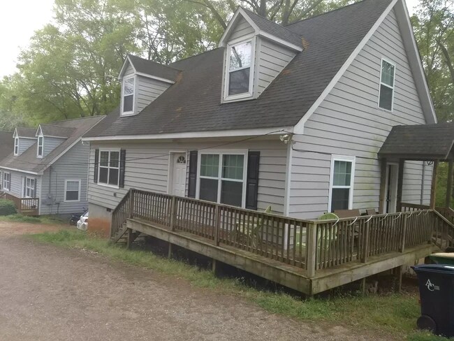
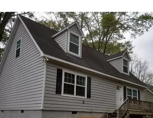
114 Simmons St Unit Group H Athens, GA 30601
Chicopee-Dudley NeighborhoodEstimated Value: $313,000 - $391,000
4
Beds
3
Baths
2,000
Sq Ft
$174/Sq Ft
Est. Value
About This Home
This home is located at 114 Simmons St Unit Group H, Athens, GA 30601 and is currently estimated at $347,830, approximately $173 per square foot. 114 Simmons St Unit Group H is a home located in Clarke County with nearby schools including Gaines Elementary School, Hilsman Middle School, and Cedar Shoals High School.
Ownership History
Date
Name
Owned For
Owner Type
Purchase Details
Closed on
Jun 5, 2018
Sold by
Guest Fam Partnership Llc
Bought by
Your Happy Home Llc
Current Estimated Value
Home Financials for this Owner
Home Financials are based on the most recent Mortgage that was taken out on this home.
Original Mortgage
$115,200
Outstanding Balance
$101,485
Interest Rate
4.5%
Mortgage Type
New Conventional
Estimated Equity
$236,670
Create a Home Valuation Report for This Property
The Home Valuation Report is an in-depth analysis detailing your home's value as well as a comparison with similar homes in the area
Home Values in the Area
Average Home Value in this Area
Purchase History
Date | Buyer | Sale Price | Title Company |
---|---|---|---|
Your Happy Home Llc | $144,000 | -- |
Source: Public Records
Mortgage History
Date | Status | Borrower | Loan Amount |
---|---|---|---|
Open | Your Happy Home Llc | $115,200 | |
Previous Owner | Guest Fam Partnership Llc | $137,000 |
Source: Public Records
Tax History Compared to Growth
Tax History
Year | Tax Paid | Tax Assessment Tax Assessment Total Assessment is a certain percentage of the fair market value that is determined by local assessors to be the total taxable value of land and additions on the property. | Land | Improvement |
---|---|---|---|---|
2024 | $3,867 | $123,758 | $24,000 | $99,758 |
2023 | $3,867 | $107,438 | $18,000 | $89,438 |
2022 | $2,833 | $88,801 | $16,000 | $72,801 |
2021 | $2,417 | $71,713 | $12,000 | $59,713 |
2020 | $2,162 | $64,166 | $10,400 | $53,766 |
2019 | $1,852 | $54,537 | $10,400 | $44,137 |
2018 | $1,473 | $43,385 | $10,400 | $32,985 |
2017 | $1,328 | $39,124 | $10,400 | $28,724 |
2016 | $1,294 | $38,107 | $10,400 | $27,707 |
2015 | $925 | $27,200 | $10,400 | $16,800 |
2014 | $926 | $27,200 | $10,400 | $16,800 |
Source: Public Records
Map
Nearby Homes
- 704 Branch St
- 702 Branch St
- 1480 E Broad St
- 342 Arch St
- 1734 E Broad St
- 320 Vine St
- 320 Vine St Unit 1 & 2
- 235 Arch St
- 250 Fairview St
- 132 N Poplar St
- 226 Vine St
- 332 Carr St
- 1295 E Broad St Unit C-1
- 1295 E Broad St Unit C1
- 290 Appleby Dr Unit 268
- 290 Appleby Dr Unit 177
- 290 Appleby Dr Unit 272
- 250 Little St Unit D202
- 250 Little St Unit D105
- 250 Little St Unit A 105
- 114 Simmons St
- 112 Simmons St
- 231 Derby St
- 227 Derby St
- 116 Simmons St
- 1594 E Broad St
- 1550 E Broad St
- 205 Derby St
- 120 Simmons St
- 235 Derby St
- 223 Derby St
- 255 Derby St
- 219 Derby St
- 0 Simmons St Unit CM368004
- 000 Simmons St
- 0 Simmons St Unit 7525770
- 0 Simmons St Unit 8358579
- 0 Simmons St Unit 8346515
- 0 Simmons St Unit 8199514
- 0 Simmons St Unit 7598387