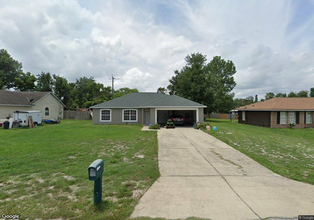
1140 Michael Ave Deltona, FL 32738
Estimated Value: $289,000 - $300,000
3
Beds
2
Baths
1,433
Sq Ft
$205/Sq Ft
Est. Value
About This Home
This home is located at 1140 Michael Ave, Deltona, FL 32738 and is currently estimated at $293,909, approximately $205 per square foot. 1140 Michael Ave is a home located in Volusia County with nearby schools including Deltona Lakes Elementary School, Heritage Middle School, and Pine Ridge High School.
Ownership History
Date
Name
Owned For
Owner Type
Purchase Details
Closed on
Jul 15, 2004
Sold by
Cacioppo & Son Of Florida Inc
Bought by
Varas Paul J and Varas Nancy E
Current Estimated Value
Home Financials for this Owner
Home Financials are based on the most recent Mortgage that was taken out on this home.
Original Mortgage
$136,000
Outstanding Balance
$68,032
Interest Rate
6.24%
Mortgage Type
VA
Estimated Equity
$225,877
Purchase Details
Closed on
Aug 22, 2003
Sold by
Formoso Giacinto
Bought by
Cacioppo & Son Fl Inc
Purchase Details
Closed on
Feb 28, 2003
Sold by
Monroe Fred B
Bought by
Formoso Giacinto
Create a Home Valuation Report for This Property
The Home Valuation Report is an in-depth analysis detailing your home's value as well as a comparison with similar homes in the area
Home Values in the Area
Average Home Value in this Area
Purchase History
| Date | Buyer | Sale Price | Title Company |
|---|---|---|---|
| Varas Paul J | $136,000 | Southern Title Holding Compa | |
| Cacioppo & Son Fl Inc | $20,000 | -- | |
| Formoso Giacinto | $10,000 | -- |
Source: Public Records
Mortgage History
| Date | Status | Borrower | Loan Amount |
|---|---|---|---|
| Open | Varas Paul J | $136,000 |
Source: Public Records
Tax History Compared to Growth
Tax History
| Year | Tax Paid | Tax Assessment Tax Assessment Total Assessment is a certain percentage of the fair market value that is determined by local assessors to be the total taxable value of land and additions on the property. | Land | Improvement |
|---|---|---|---|---|
| 2025 | $331 | $84,226 | -- | -- |
| 2024 | $331 | $81,853 | -- | -- |
| 2023 | $331 | $79,469 | $0 | $0 |
| 2022 | $331 | $77,154 | $0 | $0 |
| 2021 | $331 | $74,907 | $0 | $0 |
| 2020 | $331 | $73,873 | $0 | $0 |
| 2019 | $331 | $72,212 | $0 | $0 |
| 2018 | $311 | $70,866 | $0 | $0 |
| 2017 | $282 | $69,408 | $0 | $0 |
| 2016 | $282 | $67,980 | $0 | $0 |
| 2015 | $282 | $67,507 | $0 | $0 |
| 2014 | $250 | $66,971 | $0 | $0 |
Source: Public Records
Map
Nearby Homes
- 1961 Paragon St
- 1922 Marlow St
- 1082 Worthington Dr
- 1113 Fort Smith Blvd
- 1057 Fort Smith Blvd
- 2067 Everest St
- 2180 MacHardy Rd
- 968 Fort Smith Blvd
- 973 Radford Dr
- 2103 Watersedge Dr
- 2046 Galahad Dr
- 1422 W Orion Cir
- 2332 Salem Dr
- 1179 Snowden Ave
- 732 Fort Smith Blvd
- 747 Fort Smith Blvd
- 1656 Brentlawn St
- 2090 Lakebreeze Way
- 1649 Weybridge St
- 1771 S Village Dr
- 1148 Michael Ave
- 1132 Michael Ave
- 1165 Worthington Dr
- 1158 Michael Ave
- 1124 Michael Ave
- 1181 Worthington Dr
- 1141 Michael Ave
- 1159 Worthington Dr
- 1133 Michael Ave
- 1149 Michael Ave
- 1201 Worthington Dr
- 1168 Michael Ave
- 1116 Michael Ave
- 1125 Michael Ave
- 1159 Michael Ave
- 1149 Worthington Dr
- 1209 Worthington Dr
- 1169 Michael Ave
- 1117 Michael Ave
- 1160 Worthington Dr