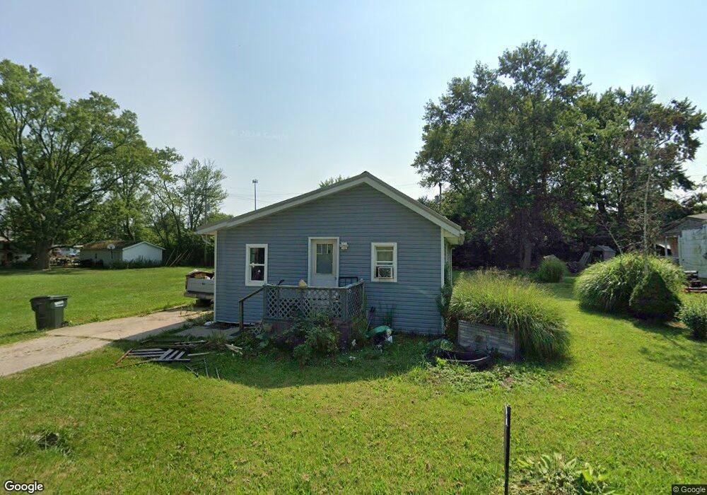
11400 Pettit Ave NE Alliance, OH 44601
Estimated Value: $74,000 - $84,493
2
Beds
1
Bath
752
Sq Ft
$107/Sq Ft
Est. Value
About This Home
This home is located at 11400 Pettit Ave NE, Alliance, OH 44601 and is currently estimated at $80,123, approximately $106 per square foot. 11400 Pettit Ave NE is a home located in Stark County with nearby schools including Marlington High School and Regina Coeli/St Joseph School.
Ownership History
Date
Name
Owned For
Owner Type
Purchase Details
Closed on
Aug 26, 2020
Sold by
Elliott Jeffrey D and Terrell Deborah A
Bought by
Hinkle Meri
Current Estimated Value
Purchase Details
Closed on
Sep 3, 2002
Sold by
Scheuerman Edward G
Bought by
Elliott Jeffrey D and Elliott Deborah A
Purchase Details
Closed on
Oct 31, 1997
Sold by
Shiock Patrick R
Bought by
Elliott Donald R and Scheuerman Edward
Purchase Details
Closed on
Nov 22, 1994
Sold by
Mohr Jeanne
Bought by
Sihock Patrick R
Create a Home Valuation Report for This Property
The Home Valuation Report is an in-depth analysis detailing your home's value as well as a comparison with similar homes in the area
Home Values in the Area
Average Home Value in this Area
Purchase History
| Date | Buyer | Sale Price | Title Company |
|---|---|---|---|
| Hinkle Meri | $23,400 | None Available | |
| Elliott Jeffrey D | $13,000 | -- | |
| Elliott Donald R | $6,000 | -- | |
| Sihock Patrick R | $2,700 | -- |
Source: Public Records
Tax History Compared to Growth
Tax History
| Year | Tax Paid | Tax Assessment Tax Assessment Total Assessment is a certain percentage of the fair market value that is determined by local assessors to be the total taxable value of land and additions on the property. | Land | Improvement |
|---|---|---|---|---|
| 2025 | -- | $21,460 | $8,680 | $12,780 |
| 2024 | -- | $21,460 | $8,680 | $12,780 |
| 2023 | $623 | $17,290 | $4,200 | $13,090 |
| 2022 | $625 | $17,290 | $4,200 | $13,090 |
| 2021 | $255 | $7,040 | $4,200 | $2,840 |
| 2020 | $334 | $8,190 | $3,640 | $4,550 |
| 2019 | $331 | $8,190 | $3,640 | $4,550 |
| 2018 | $332 | $8,190 | $3,640 | $4,550 |
| 2017 | $293 | $6,760 | $2,660 | $4,100 |
| 2016 | $293 | $6,760 | $2,660 | $4,100 |
| 2015 | $140 | $6,760 | $2,660 | $4,100 |
| 2014 | $271 | $5,990 | $2,520 | $3,470 |
| 2013 | $135 | $5,990 | $2,520 | $3,470 |
Source: Public Records
Map
Nearby Homes
- 11344 Walnut Ave NE
- 14723 Bolton St NE
- 11680 Walnut Ave NE
- 0 Meadowbrook Ave
- 0 Homestead Ave NE
- 000 Meadowbrook Ave
- 124 E Wayne St
- 0 Johnson Ave NE Unit 5142926
- 710 N Freedom Ave
- 11310 Webb Ave NE
- 511 W Ely St
- 14422 Sturbridge Rd NE
- 15995 Elbrook St NE
- 0 Klinger Ave NE
- 652 N Webb Ave
- 432 Johnson Ave
- 329 1/2 W Main St
- 000 Klinger Ave
- 163 W Market St
- 345 W Market St
- 11388 Pettit Ave NE
- 11414 Pettit Ave NE
- 11405 Tullis Ave NE
- 11424 Pettit Ave NE
- 11374 Pettit Ave NE
- 11399 Tullis Ave NE
- 11350 Pettit Ave NE
- 15166 Gaskill Dr NE
- 11421 Pettit Ave NE
- 15190 Gaskill Dr NE
- 15174 Gaskill Dr NE
- 0 Gaskill Dr NE
- 15210 Gaskill Dr NE
- 11371 Tullis Ave NE
- 11351 Tullis Ave NE
- 15110 Gaskill Dr NE
- 15240 Gaskill Dr NE
- 11325 Tullis Ave NE
- 11340 Tullis Ave NE
- 11340 Tullis Ave NE