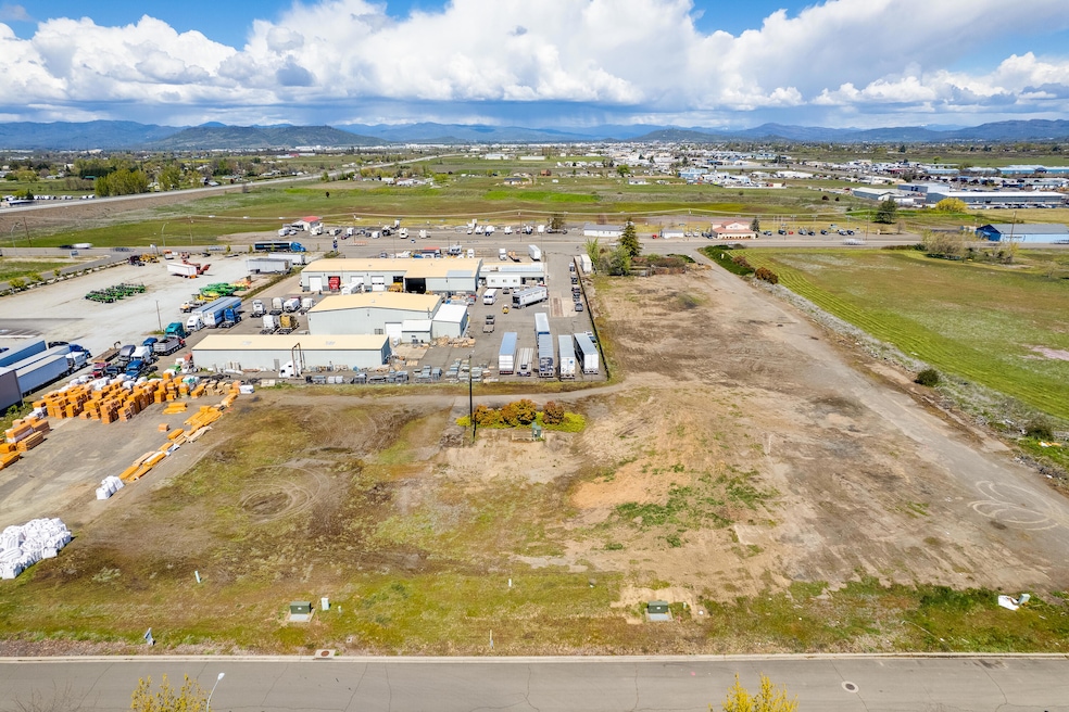
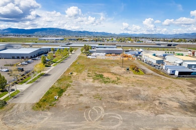
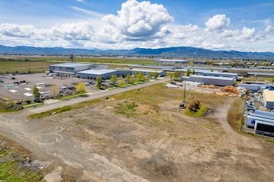

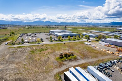
1141 Helicopter Way Medford, OR 97504
North Medford NeighborhoodEstimated payment $1,249/month
About This Lot
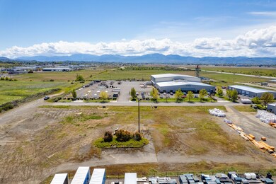
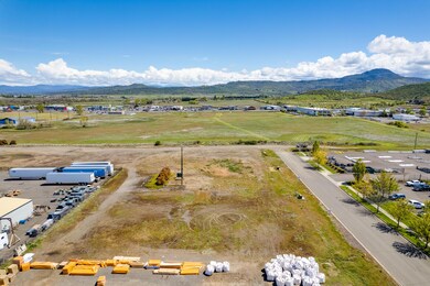
City of Medford General Industrial IG Zoned lot (s) Approximately .51 acres (each) with good access to either Highway 62 at E. -Vilas Road, Highway 140, Interstate 5 Exits #30 N. Medford, or #32 Central Point. All City utilities are stubbed to the property. In an area of well- maintained buildings; housing warehouses, suppliers, and a large mini storage complex. Lot(s) are situated on Helicopter Way not a through street with access to East Vilas Road via Helicopter Dr. See adjacent properties listed for sale; 1151 Helicopter Way & 1250 Vilas R
Property Details
Property Type
- Land
Est. Annual Taxes
- $2,674
Lot Details
- 0.51 Acre Lot
- Property is zoned Medford-I-G, Medford-I-G
Schools
- Wilson Elementary School
- Hedrick Middle School
- North Medford High School
Community Details
- No Home Owners Association
Listing and Financial Details
- Assessor Parcel Number 10987475
Map
Home Values in the Area
Average Home Value in this Area
Tax History
| Year | Tax Paid | Tax Assessment Tax Assessment Total Assessment is a certain percentage of the fair market value that is determined by local assessors to be the total taxable value of land and additions on the property. | Land | Improvement |
|---|---|---|---|---|
| 2025 | $2,674 | $184,350 | $184,350 | -- |
| 2024 | $2,674 | $178,990 | $178,990 | -- |
| 2023 | $2,592 | $173,780 | $173,780 | $0 |
| 2022 | $2,529 | $173,780 | $173,780 | $0 |
| 2021 | $2,463 | $168,720 | $168,720 | $0 |
| 2020 | $2,411 | $163,810 | $163,810 | $0 |
| 2019 | $2,354 | $154,410 | $154,410 | $0 |
| 2018 | $2,294 | $149,920 | $149,920 | $0 |
| 2017 | $2,253 | $149,920 | $149,920 | $0 |
| 2016 | $2,216 | $138,740 | $138,740 | $0 |
| 2015 | $2,245 | $145,560 | $145,560 | $0 |
| 2014 | $2,205 | $137,220 | $137,220 | $0 |
Property History
| Date | Event | Price | List to Sale | Price per Sq Ft |
|---|---|---|---|---|
| 10/09/2025 10/09/25 | For Sale | $195,000 | 0.0% | -- |
| 10/06/2025 10/06/25 | Off Market | $195,000 | -- | -- |
| 07/11/2023 07/11/23 | Price Changed | $195,000 | -6.0% | -- |
| 03/31/2023 03/31/23 | Price Changed | $207,500 | -5.7% | -- |
| 07/19/2022 07/19/22 | Price Changed | $220,000 | -6.4% | -- |
| 04/08/2022 04/08/22 | For Sale | $235,000 | -- | -- |
Source: Oregon Datashare
MLS Number: 220142932
APN: 10987475
Disclaimer: Certain information contained herein is derived from information provided by parties other than Homes.com. All information provided is deemed reliable, but is not guaranteed to be accurate and should be independently verified.
![]() © 2025 Oregon Datashare (KCAR | MLSCO | SOMLS). All rights reserved. The data relating to real estate for sale on this web site comes in part from the Internet Data Exchange Program of the Oregon Datashare. Real estate listings held by IDX Brokerage firms other than Ten-X are marked with the Internet Data Exchange logo or the Internet Data Exchange thumbnail logo and detailed information about them includes the name of the listing Brokers. Information provided is for consumers' personal, non-commercial use and may not be used for any purpose other than to identify prospective properties the viewer may be interested in purchasing. The consumer will not copy, retransmit nor redistribute any of the content from this website. Information provided is deemed reliable, but not guaranteed.
© 2025 Oregon Datashare (KCAR | MLSCO | SOMLS). All rights reserved. The data relating to real estate for sale on this web site comes in part from the Internet Data Exchange Program of the Oregon Datashare. Real estate listings held by IDX Brokerage firms other than Ten-X are marked with the Internet Data Exchange logo or the Internet Data Exchange thumbnail logo and detailed information about them includes the name of the listing Brokers. Information provided is for consumers' personal, non-commercial use and may not be used for any purpose other than to identify prospective properties the viewer may be interested in purchasing. The consumer will not copy, retransmit nor redistribute any of the content from this website. Information provided is deemed reliable, but not guaranteed.
- 1151 Helicopter Way
- 1250 Vilas Rd
- 5011 Highway 62
- 4702 Industry Dr
- 4676 Industry Dr
- 2453 Crater Lake Hwy
- 862 Enterprise Dr
- 4824 Airway Dr Unit 371W06BB410
- 1182 E Justice Rd
- 5156 Peace Ln
- 4692 Crater Lake Ave Unit 600
- 1816 E Vilas Rd
- 2457 Coker Butte Rd
- 1850 Coker Butte Rd
- 0 Crater Lake Ave Unit 11.27 220200854
- 0 Crater Lake Ave Unit 13.52 220200855
- 1528 Skyhawk
- 1629 Husker Butte Ln
- 0 Arrowhead Dr Unit 113 220196379
- 4399 Table Rock Rd
- 2190 Poplar Dr
- 1801 Poplar Dr
- 2364 Howard Ave
- 700 N Haskell St
- 237 E McAndrews Rd
- 1116 Niantic St Unit 3
- 645 Royal Ave
- 518 N Riverside Ave
- 520 N Bartlett St
- 406 W Main St
- 121 S Holly St
- 309 Laurel St
- 2642 W Main St
- 534 Hamilton St Unit 534
- 536 Hamilton St Unit 536
- 835 Overcup St
- 2532 Juanipero Way
- 353 Dalton St
- 1661 S Columbus Ave
- 396 Patricia Ln
