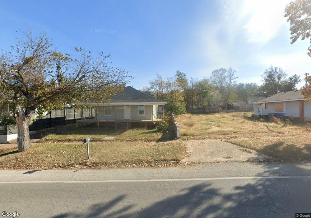
1141 W 1st St Sulphur, OK 73086
Estimated Value: $74,360 - $109,000
2
Beds
1
Bath
1,352
Sq Ft
$68/Sq Ft
Est. Value
About This Home
This home is located at 1141 W 1st St, Sulphur, OK 73086 and is currently estimated at $91,590, approximately $67 per square foot. 1141 W 1st St is a home located in Murray County with nearby schools including Sulphur Elementary School, Sulphur Intermediate School, and Sulphur Middle School.
Ownership History
Date
Name
Owned For
Owner Type
Purchase Details
Closed on
Nov 27, 2012
Sold by
Lancaster Bradley
Bought by
Kirby Leslie and Kirby Summer
Current Estimated Value
Home Financials for this Owner
Home Financials are based on the most recent Mortgage that was taken out on this home.
Original Mortgage
$39,379
Outstanding Balance
$26,990
Interest Rate
3.37%
Mortgage Type
Future Advance Clause Open End Mortgage
Estimated Equity
$64,600
Purchase Details
Closed on
Dec 21, 2010
Sold by
Martin Bobby Joe and Martin Evelyn Kay
Bought by
Lancaster Bradley
Create a Home Valuation Report for This Property
The Home Valuation Report is an in-depth analysis detailing your home's value as well as a comparison with similar homes in the area
Home Values in the Area
Average Home Value in this Area
Purchase History
| Date | Buyer | Sale Price | Title Company |
|---|---|---|---|
| Kirby Leslie | $45,000 | None Available | |
| Lancaster Bradley | $9,000 | None Available |
Source: Public Records
Mortgage History
| Date | Status | Borrower | Loan Amount |
|---|---|---|---|
| Open | Kirby Leslie | $39,379 |
Source: Public Records
Tax History Compared to Growth
Tax History
| Year | Tax Paid | Tax Assessment Tax Assessment Total Assessment is a certain percentage of the fair market value that is determined by local assessors to be the total taxable value of land and additions on the property. | Land | Improvement |
|---|---|---|---|---|
| 2025 | $67 | $693 | $693 | $0 |
| 2024 | $67 | $660 | $660 | $0 |
| 2023 | $63 | $5,682 | $660 | $5,022 |
| 2022 | $488 | $5,412 | $660 | $4,752 |
| 2021 | $471 | $5,412 | $660 | $4,752 |
| 2020 | $464 | $5,339 | $660 | $4,679 |
| 2019 | $475 | $5,339 | $660 | $4,679 |
| 2018 | $468 | $5,198 | $660 | $4,538 |
| 2017 | $449 | $4,950 | $660 | $4,290 |
| 2016 | $461 | $4,950 | $235 | $4,715 |
| 2015 | $428 | $4,950 | $235 | $4,715 |
| 2014 | $437 | $4,950 | $235 | $4,715 |
Source: Public Records
Map
Nearby Homes
- 0 0092-00-009-013-0-013-00 Unit 1187198
- 1220 Division St
- 0 Eagle Unit 2530641
- 1 Eagle
- 0 Eagle Unit 2530643
- 114 E Vinita Ave
- 129 W Tahlequah Ave
- 128 W Tahlequah Ave
- 1112 E 2nd St
- 108 E Tahlequah Ave
- 1200 E 4th St
- 1107 E 4th St
- 1603 E 2nd St
- 003 U S 177
- 005 U S 177
- 006 U S 177
- 001 U S 177
- 2500 U S 177
- 002 U S 177
- 401 E Tahlequah Ave
- 1147 W 1st St
- 1139 W 1st St
- 1133 W 1st St
- 1148 Division St
- 1152 Division St
- 1142 Division St
- 1138 Division St
- 1146 W 1st St
- 1134 Division St
- 16 W Wynnewood Ave
- 18 Marietta Ave
- 22 W Wynnewood Ave
- 1130 Division St
- 1200 Division St
- 17 Marietta Ave
- 1127 Division St
- 15 Marietta Ave
- 1131 Division St
- 1123 Division St
- 15 W Oklahoma Ave