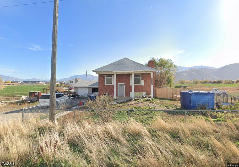
11411 S 4800 W Payson, UT 84651
4
Beds
1
Bath
1,305
Sq Ft
43,560
Sq Ft Lot
About This Home
This home is located at 11411 S 4800 W, Payson, UT 84651. 11411 S 4800 W is a home located in Utah County with nearby schools including Taylor Elementary School, Salem Junior High School, and Valley View Middle School.
Create a Home Valuation Report for This Property
The Home Valuation Report is an in-depth analysis detailing your home's value as well as a comparison with similar homes in the area
Home Values in the Area
Average Home Value in this Area
Tax History
| Year | Tax Paid | Tax Assessment Tax Assessment Total Assessment is a certain percentage of the fair market value that is determined by local assessors to be the total taxable value of land and additions on the property. | Land | Improvement |
|---|---|---|---|---|
| 2024 | $2,461 | $250,470 | $0 | $0 |
| 2023 | $2,388 | $243,650 | $0 | $0 |
| 2022 | $2,441 | $244,970 | $0 | $0 |
| 2021 | $2,136 | $343,900 | $150,000 | $193,900 |
| 2020 | $2,025 | $318,900 | $125,000 | $193,900 |
| 2019 | $1,773 | $286,300 | $110,000 | $176,300 |
| 2018 | $1,657 | $257,900 | $90,000 | $167,900 |
| 2017 | $1,412 | $118,195 | $0 | $0 |
| 2016 | $1,104 | $91,795 | $0 | $0 |
| 2015 | $794 | $85,580 | $0 | $0 |
| 2014 | $1,144 | $85,580 | $0 | $0 |
Source: Public Records
Map
Nearby Homes
- 1963 W 1150 S Unit 1032
- 1967 W 1150 S Unit 1033
- 1971 W 1150 S Unit 1034
- 1973 W 1150 S Unit 1035
- 1979 W 1150 S Unit 1036
- 1983 W 1150 S Unit 1037
- 1218 S 1740 W
- 2011 W 1150 S Unit 1042
- 1208 S 1740 W
- 2031 W 1150 S Unit 1044
- 1964 W 1150 S Unit 1029
- 1968 W 1150 S Unit 1028
- 1972 W 1150 S Unit 1027
- 1984 W 1150 S Unit 1024
- 1992 W 1150 S Unit 1022
- 9022 S 4400 W
- 2200 W 1130 St S
- 841 N Dryland Cir Unit BALLAR
- 841 N Dryland Cir Unit DREXEL
- 841 N Dryland Cir Unit HILDAL
- 1367 S 1950 W
- 11397 S 4800 W
- 1417 S 1950 W
- 11480 S 4800 W
- 11495 S 4800 W
- 11515 S 4800 W
- 9335 S 1950 W
- 11356 S 4800 W
- 11328 S 4800 W
- 11315 S 4800 W
- 1425 S 1950 W
- 11808 S West Mountain Rd
- 11838 S West Mountain Rd
- 4888 W 11560 S
- 1235 S 1950 W
- 1412 S 1700 W
- 1252 S 1950 W
- 2194 W 1470 S
- 1354 S 1700 W
- 1173 S 1950 W
Your Personal Tour Guide
Ask me questions while you tour the home.