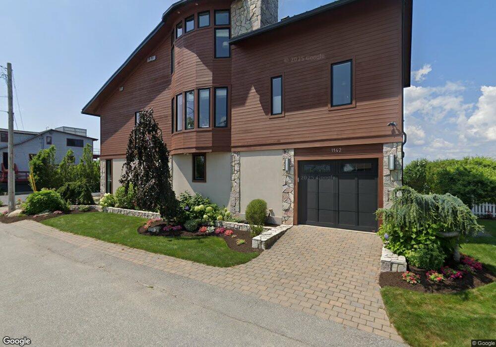
1142 Anthony Rd Portsmouth, RI 02871
Common Fence Point NeighborhoodEstimated Value: $1,013,000 - $1,495,000
2
Beds
1
Bath
1,128
Sq Ft
$1,146/Sq Ft
Est. Value
About This Home
This home is located at 1142 Anthony Rd, Portsmouth, RI 02871 and is currently estimated at $1,293,158, approximately $1,146 per square foot. 1142 Anthony Rd is a home located in Newport County with nearby schools including Portsmouth High School.
Ownership History
Date
Name
Owned For
Owner Type
Purchase Details
Closed on
Jun 23, 2006
Sold by
Helme Elizabeth
Bought by
Culpan Jeffrey and Culpan Kim
Current Estimated Value
Home Financials for this Owner
Home Financials are based on the most recent Mortgage that was taken out on this home.
Original Mortgage
$200,000
Interest Rate
6.59%
Mortgage Type
Purchase Money Mortgage
Purchase Details
Closed on
Jun 28, 2001
Sold by
Hitchen James E and Hitchen Ann S
Bought by
Helme Elizabeth S
Purchase Details
Closed on
Jun 21, 1993
Sold by
Medeiros Manuel E and Medeiros Frences
Bought by
Hitchen James E and Hitchen Ann
Create a Home Valuation Report for This Property
The Home Valuation Report is an in-depth analysis detailing your home's value as well as a comparison with similar homes in the area
Home Values in the Area
Average Home Value in this Area
Purchase History
| Date | Buyer | Sale Price | Title Company |
|---|---|---|---|
| Culpan Jeffrey | $562,500 | -- | |
| Helme Elizabeth S | $305,000 | -- | |
| Hitchen James E | $125,000 | -- |
Source: Public Records
Mortgage History
| Date | Status | Borrower | Loan Amount |
|---|---|---|---|
| Open | Hitchen James E | $170,000 | |
| Open | Hitchen James E | $300,000 | |
| Closed | Hitchen James E | $200,000 | |
| Previous Owner | Hitchen James E | $240,000 |
Source: Public Records
Tax History Compared to Growth
Tax History
| Year | Tax Paid | Tax Assessment Tax Assessment Total Assessment is a certain percentage of the fair market value that is determined by local assessors to be the total taxable value of land and additions on the property. | Land | Improvement |
|---|---|---|---|---|
| 2025 | $12,482 | $939,900 | $505,300 | $434,600 |
| 2024 | $12,388 | $939,900 | $505,300 | $434,600 |
| 2023 | $12,012 | $939,900 | $505,300 | $434,600 |
| 2022 | $10,450 | $671,600 | $350,600 | $321,000 |
| 2021 | $10,282 | $671,600 | $350,600 | $321,000 |
| 2020 | $10,121 | $671,600 | $350,600 | $321,000 |
| 2019 | $9,999 | $609,700 | $288,700 | $321,000 |
| 2018 | $9,737 | $609,700 | $288,700 | $321,000 |
| 2017 | $9,402 | $609,700 | $288,700 | $321,000 |
| 2016 | $9,910 | $619,400 | $298,700 | $320,700 |
| 2015 | $9,787 | $619,400 | $298,700 | $320,700 |
| 2014 | $9,787 | $619,400 | $298,700 | $320,700 |
Source: Public Records
Map
Nearby Homes
- 1055 Anthony Rd
- 0 Island Rd
- 1350 Anthony Rd
- 0 Common Fence Blvd Unit 1364650
- 0 Common Fence Blvd Unit 1397142
- 169 Narragansett Blvd
- 134 Greenfield Ave
- 10 Mount Hope Ave
- 72 Rhode Island Blvd
- 0 Dighton Ave
- 83 Waters Edge Unit 24
- 87 Waters Edge
- 42 Lewis St
- 171 Leeshore Ln
- 9 Cutter Ln
- 47 Watermark Dr
- 8 Tucker Ave
- 50 Stevens St
- 24 Bismark Ave
- 15 Rocky Ave
- 0 Narragansett Rd
- 1150 Anthony Rd
- 1130 Anthony Rd
- 1156 Anthony Rd
- 1127 Anthony Rd
- 1155 Anthony Rd
- 1103 Anthony Rd
- 247 Sakonnet Dr
- 239 Sakonnet Dr
- 1162 Anthony Rd
- 19 Narragansett Rd
- 1115 Anthony Rd
- 212 Sakonnet Dr
- 1172 Anthony Rd
- 28 Narragansett Rd
- 31 Narragansett Rd
- 36 Narragansett Rd
- 1171 Anthony Rd
- 1105 Anthony Rd
- 1128 Anthony Rd