Estimated Value: $387,000 - $397,384
3
Beds
1
Bath
1,152
Sq Ft
$340/Sq Ft
Est. Value
About This Home
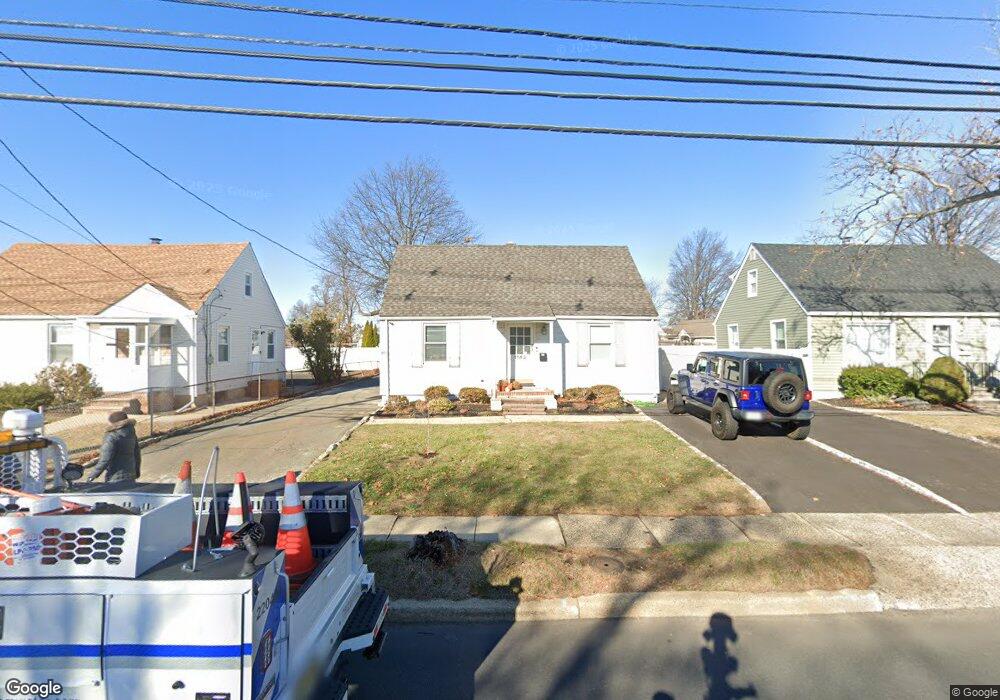
This home is located at 1142 Raritan Rd, Clark, NJ 07066 and is currently estimated at $392,192, approximately $340 per square foot. 1142 Raritan Rd is a home located in Union County with nearby schools including Frank K. Hehnly Elementary School, Carl H. Kumpf Middle School, and Arthur L. Johnson High School.
Ownership History
Date
Name
Owned For
Owner Type
Purchase Details
Closed on
Nov 29, 2023
Sold by
1142-1150 Raritan Rd Llc
Bought by
Venturi Silveira Anderson
Current Estimated Value
Home Financials for this Owner
Home Financials are based on the most recent Mortgage that was taken out on this home.
Original Mortgage
$266,000
Interest Rate
7.79%
Mortgage Type
New Conventional
Purchase Details
Closed on
Dec 29, 2021
Sold by
Araneo Anthony M and Araneo Ethel
Bought by
1142-50 Raritan Rd Llc
Home Financials for this Owner
Home Financials are based on the most recent Mortgage that was taken out on this home.
Original Mortgage
$562,500
Interest Rate
3.45%
Mortgage Type
New Conventional
Purchase Details
Closed on
Aug 16, 2019
Sold by
Araneo Anthony M
Bought by
Araneo Anthony M and Araneo Ethel
Create a Home Valuation Report for This Property
The Home Valuation Report is an in-depth analysis detailing your home's value as well as a comparison with similar homes in the area
Home Values in the Area
Average Home Value in this Area
Purchase History
| Date | Buyer | Sale Price | Title Company |
|---|---|---|---|
| Venturi Silveira Anderson | $356,000 | Bonafide Title | |
| Venturi Silveira Anderson | $356,000 | Bonafide Title | |
| 1142-50 Raritan Rd Llc | $750,000 | Pankiewicz Martin | |
| Araneo Anthony M | -- | None Available |
Source: Public Records
Mortgage History
| Date | Status | Borrower | Loan Amount |
|---|---|---|---|
| Previous Owner | Venturi Silveira Anderson | $266,000 | |
| Previous Owner | 1142-50 Raritan Rd Llc | $562,500 |
Source: Public Records
Tax History Compared to Growth
Tax History
| Year | Tax Paid | Tax Assessment Tax Assessment Total Assessment is a certain percentage of the fair market value that is determined by local assessors to be the total taxable value of land and additions on the property. | Land | Improvement |
|---|---|---|---|---|
| 2025 | $7,877 | $355,800 | $225,000 | $130,800 |
| 2024 | $7,760 | $355,800 | $225,000 | $130,800 |
| 2023 | $7,760 | $355,800 | $225,000 | $130,800 |
| 2022 | $7,536 | $355,800 | $225,000 | $130,800 |
| 2021 | $8,499 | $95,600 | $55,000 | $40,600 |
| 2020 | $8,360 | $95,600 | $55,000 | $40,600 |
| 2019 | $8,276 | $95,600 | $55,000 | $40,600 |
| 2018 | $8,177 | $95,600 | $55,000 | $40,600 |
| 2017 | $8,046 | $95,600 | $55,000 | $40,600 |
| 2016 | $7,749 | $95,600 | $55,000 | $40,600 |
| 2015 | $7,671 | $95,600 | $55,000 | $40,600 |
| 2014 | $7,509 | $95,600 | $55,000 | $40,600 |
Source: Public Records
Map
Nearby Homes
- 17 Garside Place
- 1920 Boynton Ave
- 4 Winters Ct Unit 4
- 1508 Boulevard
- 47 Florence Dr
- 18 Colin Kelly St
- 118 Cambridge Rd
- 12 Bartell Place
- 81 White Place
- 22 Harwich Ct
- 26 Manchester Dr
- 157 Westfield Ave
- 13 Sunset Dr
- 2 Byron Ct
- 279 Madison Hill Rd
- 15 Sunset Dr
- 631 Kensington Dr
- 10 Alan O Kell Place
- 54 White Place
- 1283 Rahway Ave