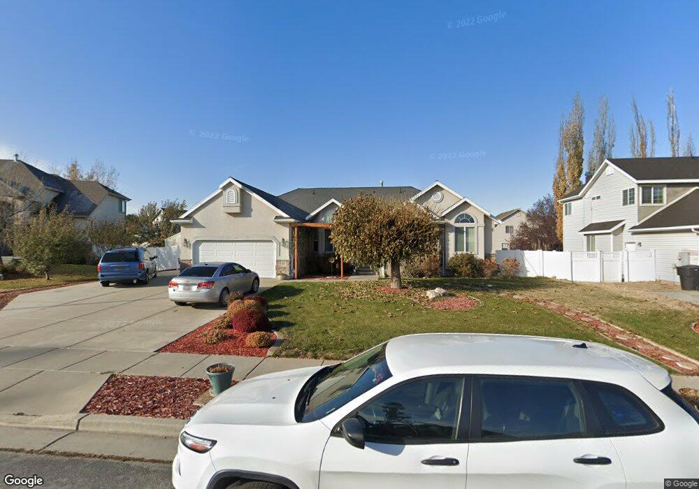
1143 N 1170 W Clearfield, UT 84015
Estimated Value: $561,000 - $599,000
4
Beds
4
Baths
3,621
Sq Ft
$160/Sq Ft
Est. Value
About This Home
This home is located at 1143 N 1170 W, Clearfield, UT 84015 and is currently estimated at $579,654, approximately $160 per square foot. 1143 N 1170 W is a home located in Davis County with nearby schools including Clinton Elementary School, Sunset Junior High School, and Clearfield High School.
Ownership History
Date
Name
Owned For
Owner Type
Purchase Details
Closed on
Aug 3, 2018
Sold by
Allen Richard D and Allen Monica
Bought by
Allen Monica J and Allen Revocable Family Trust
Current Estimated Value
Purchase Details
Closed on
Nov 4, 2013
Sold by
Samariville Llc
Bought by
Allen Richard D and Allen Monica
Purchase Details
Closed on
Jan 12, 2013
Sold by
Allen Richard D and Allen Monica
Bought by
Samarville Llc
Purchase Details
Closed on
May 18, 2009
Sold by
Conlan Andrew
Bought by
Allen Richard D and Allen Monica
Home Financials for this Owner
Home Financials are based on the most recent Mortgage that was taken out on this home.
Original Mortgage
$272,000
Interest Rate
4.82%
Mortgage Type
VA
Purchase Details
Closed on
Nov 26, 2001
Sold by
Gmw Development Inc
Bought by
Conlan Andrew
Home Financials for this Owner
Home Financials are based on the most recent Mortgage that was taken out on this home.
Original Mortgage
$221,180
Interest Rate
6.57%
Create a Home Valuation Report for This Property
The Home Valuation Report is an in-depth analysis detailing your home's value as well as a comparison with similar homes in the area
Home Values in the Area
Average Home Value in this Area
Purchase History
| Date | Buyer | Sale Price | Title Company |
|---|---|---|---|
| Allen Monica J | -- | None Available | |
| Allen Richard D | -- | None Available | |
| Samarville Llc | -- | None Available | |
| Allen Richard D | -- | Mountain View Title | |
| Conlan Andrew | -- | Bonneville Title Company Inc |
Source: Public Records
Mortgage History
| Date | Status | Borrower | Loan Amount |
|---|---|---|---|
| Previous Owner | Allen Richard D | $272,000 | |
| Previous Owner | Conlan Andrew | $221,180 |
Source: Public Records
Tax History
| Year | Tax Paid | Tax Assessment Tax Assessment Total Assessment is a certain percentage of the fair market value that is determined by local assessors to be the total taxable value of land and additions on the property. | Land | Improvement |
|---|---|---|---|---|
| 2025 | -- | $292,050 | $93,812 | $198,238 |
| 2024 | -- | $295,900 | $102,757 | $193,143 |
| 2023 | $1,380 | $522,000 | $117,547 | $404,453 |
| 2022 | $1,380 | $306,900 | $71,130 | $235,770 |
| 2021 | $744 | $410,000 | $90,356 | $319,644 |
| 2020 | $396 | $354,000 | $77,478 | $276,522 |
| 2019 | $318 | $336,000 | $89,243 | $246,757 |
| 2018 | $201 | $312,000 | $75,210 | $236,790 |
| 2016 | $2,016 | $145,145 | $27,768 | $117,377 |
| 2015 | $1,984 | $135,795 | $27,768 | $108,027 |
| 2014 | $1,938 | $134,772 | $27,768 | $107,004 |
| 2013 | $1,918 | $131,373 | $27,143 | $104,230 |
Source: Public Records
Map
Nearby Homes
Your Personal Tour Guide
Ask me questions while you tour the home.