
Seller's Agent in 2024
Jeffrey Caudill
RE/MAX
(276) 620-5625
4 in this area
184 Total Sales

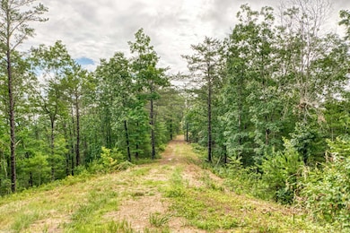

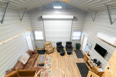
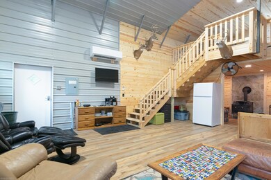

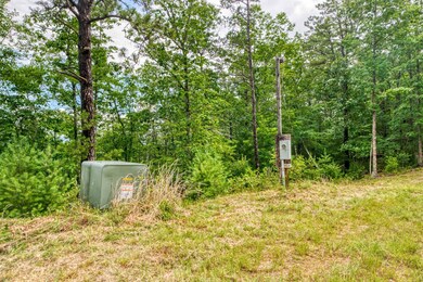
Welcome to a captivating property, a haven where nature's charm reigns supreme. Lush woods, open trails, and exceptional hunting grounds beckon the adventurous soul. With a well, composting toilet, underground power, and roads throughout, comfort and sustainability converge seamlessly. Tranquility awaits with creek access and a private dock, while panoramic mountain views astound from the cleared homesite. Boundaries blend into endless exploration as the property adjoins a national forest and the iconic Appalachian Trail. Discover the remarkable barndo, boasting power, sleeping quarters, and unrivaled craftsmanship. It stands as a testament to the property's versatility, ideal for hosting guests or relishing solitude amidst untamed beauty. Unlock boundless possibilities: an escape from city life, an exclusive hunting camp, or a luxurious vacation retreat. Embrace nature's grandeur – claim this exceptional wilderness retreat today!
Last Agent to Sell the Property
RE/MAX Land Mark Real Estate License #225078634 Listed on: 07/25/2023
| Date | Status | Loan Amount | Loan Type |
|---|---|---|---|
| Closed | $40,000 | Credit Line Revolving |
| Date | Event | Price | Change | Sq Ft Price |
|---|---|---|---|---|
| 08/21/2024 08/21/24 | Sold | $425,000 | -2.3% | -- |
| 07/01/2024 07/01/24 | Pending | -- | -- | -- |
| 07/01/2024 07/01/24 | For Sale | $435,000 | +2.4% | -- |
| 07/01/2024 07/01/24 | Off Market | $425,000 | -- | -- |
| 05/20/2024 05/20/24 | Price Changed | $435,000 | -9.2% | -- |
| 03/08/2024 03/08/24 | Price Changed | $479,000 | -8.8% | -- |
| 12/06/2023 12/06/23 | Price Changed | $525,000 | -12.5% | -- |
| 07/25/2023 07/25/23 | For Sale | $599,900 | -- | -- |
| Year | Tax Paid | Tax Assessment Tax Assessment Total Assessment is a certain percentage of the fair market value that is determined by local assessors to be the total taxable value of land and additions on the property. | Land | Improvement |
|---|---|---|---|---|
| 2024 | $956 | $159,400 | $83,500 | $75,900 |
| 2023 | $956 | $159,400 | $83,500 | $75,900 |
| 2022 | $956 | $159,400 | $83,500 | $75,900 |
| 2021 | $712 | $159,400 | $83,500 | $75,900 |
| 2020 | $956 | $177,900 | $83,500 | $94,400 |
| 2019 | $690 | $173,400 | $83,500 | $89,900 |
| 2018 | $690 | $173,400 | $83,500 | $89,900 |
| 2017 | $690 | $173,400 | $83,500 | $89,900 |
| 2016 | -- | $173,400 | $83,500 | $89,900 |
| 2015 | -- | $0 | $0 | $0 |
| 2014 | -- | $0 | $0 | $0 |
| 2013 | -- | $0 | $0 | $0 |
Seller's Agent in 2024
Jeffrey Caudill
RE/MAX
(276) 620-5625
4 in this area
184 Total Sales
Seller Co-Listing Agent in 2024
Ben Caudill
RE/MAX
(276) 620-9493
1 in this area
86 Total Sales
Buyer's Agent in 2024
Jamie Criner
GRAVITY Real Estate Group, Inc.
(540) 818-8133
1 in this area
117 Total Sales
Source: New River Valley Association of REALTORS®
MLS Number: 418743
APN: 54-A-11-01
Disclaimer: Certain information contained herein is derived from information provided by parties other than Homes.com. All information provided is deemed reliable, but is not guaranteed to be accurate and should be independently verified.
![]() IDX information is provided exclusively for personal, non-commercial use, and may not be used for any purpose other than to identify prospective properties consumers may be interested in purchasing. Information is deemed reliable but not guaranteed.
IDX information is provided exclusively for personal, non-commercial use, and may not be used for any purpose other than to identify prospective properties consumers may be interested in purchasing. Information is deemed reliable but not guaranteed.