
Estimated payment $2,087/month
Highlights
- No HOA
- Patio
- Shed
- 2 Car Attached Garage
- Bathroom on Main Level
- Central Air
About This Home
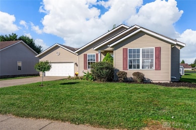
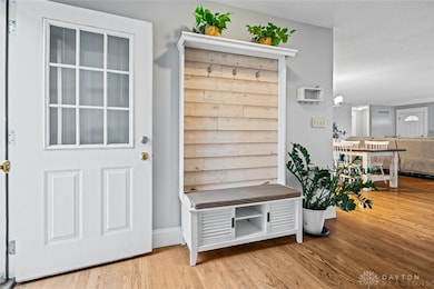
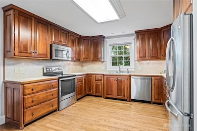
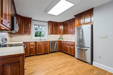
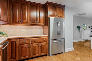
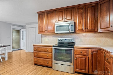
Welcome home to this nicely updated four-bedroom ranch in a convenient Xenia location. The main level features a bright, inviting living space and a spacious bonus room that’s perfect for a family media area, home office, or creative studio. You’ll love the kitchen with solid wood cabinetry, plenty of counter space, and easy access to lounging areas for effortless entertaining. The primary bedroom offers a quiet retreat near the main living spaces, while two additional main-level bedrooms provide flexible options for family, guests, or a home workspace. A standout feature is the finished basement, which includes a full bathroom and a true fourth bedroom, creating ideal guest accommodations or a private suite for teens. The finished lower level adds valuable extra living space for recreation, a workout zone, or storage without sacrificing style. A big backyard extends your living space outdoors, perfect for summer barbecues, playtime, and gardening. This home also benefits from close proximity to schools and an array of restaurants, making errands and outings a breeze. Practical updates and a cohesive, refreshed feel give you peace of mind and a smooth move-in experience. Updates include new roof and siding in 2012, water softener and water heater in 2024. Rec room on main level has its own heating and cooling system.
Listing Agent
Coldwell Banker Heritage Brokerage Phone: (937) 439-4500 License #2007004252 Listed on: 10/16/2025

Home Details
Home Type
- Single Family
Est. Annual Taxes
- $3,584
Year Built
- 2000
Lot Details
- 0.3 Acre Lot
- Lot Dimensions are 73x180x73x180
- Fenced
Parking
- 2 Car Attached Garage
Home Design
- Vinyl Siding
Interior Spaces
- 2,688 Sq Ft Home
- 1-Story Property
- Finished Basement
- Basement Fills Entire Space Under The House
Kitchen
- Range
- Microwave
- Dishwasher
- Disposal
Bedrooms and Bathrooms
- 3 Bedrooms
- Bathroom on Main Level
- 3 Full Bathrooms
Laundry
- Dryer
- Washer
Outdoor Features
- Patio
- Shed
Utilities
- Central Air
- Heating System Uses Natural Gas
- Water Softener
Community Details
- No Home Owners Association
- Westwood Subdivision
Listing and Financial Details
- Assessor Parcel Number M40000100340001400
Map
Home Values in the Area
Average Home Value in this Area
Tax History
| Year | Tax Paid | Tax Assessment Tax Assessment Total Assessment is a certain percentage of the fair market value that is determined by local assessors to be the total taxable value of land and additions on the property. | Land | Improvement |
|---|---|---|---|---|
| 2024 | $3,584 | $83,760 | $11,310 | $72,450 |
| 2023 | $3,584 | $83,760 | $11,310 | $72,450 |
| 2022 | $2,923 | $58,270 | $8,070 | $50,200 |
| 2021 | $2,963 | $57,420 | $8,070 | $49,350 |
| 2020 | $2,491 | $57,420 | $8,070 | $49,350 |
| 2019 | $2,491 | $48,130 | $6,040 | $42,090 |
| 2018 | $2,500 | $48,130 | $6,040 | $42,090 |
| 2017 | $2,428 | $48,130 | $6,040 | $42,090 |
| 2016 | $2,356 | $44,510 | $6,040 | $38,470 |
| 2015 | $1,181 | $44,510 | $6,040 | $38,470 |
| 2014 | $1,100 | $44,510 | $6,040 | $38,470 |
Property History
| Date | Event | Price | List to Sale | Price per Sq Ft |
|---|---|---|---|---|
| 10/28/2025 10/28/25 | Price Changed | $339,900 | -2.9% | $172 / Sq Ft |
| 10/16/2025 10/16/25 | For Sale | $349,900 | -- | $177 / Sq Ft |
Purchase History
| Date | Type | Sale Price | Title Company |
|---|---|---|---|
| Warranty Deed | $147,500 | Stewart Title Guaranty Co | |
| Warranty Deed | $147,900 | Attorney | |
| Deed | $19,000 | -- |
Mortgage History
| Date | Status | Loan Amount | Loan Type |
|---|---|---|---|
| Previous Owner | $107,000 | New Conventional | |
| Previous Owner | $147,900 | VA |
Source: Dayton REALTORS®
MLS Number: 945708
APN: M40-0001-0034-0-0014-00
Disclaimer: Certain information contained herein is derived from information provided by parties other than Homes.com. All information provided is deemed reliable, but is not guaranteed to be accurate and should be independently verified.
![]() The information is being provided by Dayton Area Board of Realtors MLS. Information deemed reliable but not guaranteed. Information is provided for the consumer's personal, non-commercial use, and may not be used for any purpose other than the identification of potential properties for purchase. Copyright 2025 Dayton Area Board of Realtors MLS. All Rights Reserved.
The information is being provided by Dayton Area Board of Realtors MLS. Information deemed reliable but not guaranteed. Information is provided for the consumer's personal, non-commercial use, and may not be used for any purpose other than the identification of potential properties for purchase. Copyright 2025 Dayton Area Board of Realtors MLS. All Rights Reserved.
- 1342 Kylemore Dr
- 1568 Cheyenne Dr
- 1618 Navajo Dr
- 1208 Bellbrook Ave
- 1391 June Dr
- 1272 Bellbrook Ave
- 1283 June Dr
- 1223 June Dr
- 1653 Seneca Dr
- 1778 Arapaho Dr
- 121 S Progress Dr
- 2758 Wyoming Dr
- 1769 Gayhart Dr
- 1351 Omard Dr
- 343 Sheelin Rd
- 1829 Gayhart Dr
- 1866 Roxbury Dr
- 305-325 Bellbrook Ave
- 219 Kansas Dr
- 2015 Iowa Dr
- 1600 Deer Creek Dr
- 475 Stelton Rd Unit 479
- 475 Stelton Rd Unit 475
- 1479 Colorado Dr
- 1255 Arkansas Dr
- 643 Smith Ave
- 1337 Vimla Way
- 1302 Shannon Ln
- 769 Hilltop Rd
- 2436 Sherbourne Way
- 1075 Meadow Dr
- 2177 Bandit Trail
- 1400 Parkman Place Unit 1406
- 337 Honey Jane Dr
- 1130 Cymar Dr E
- 1285 Wallaby Dr
- 1615 N Fairfield Rd
- 3724 Aftonshire Dr
- 3764 Woodbrook Way
- 2435 Forest Oaks Dr