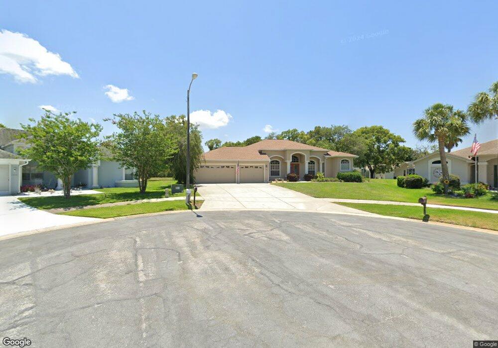
1145 Bunker Ct Spring Hill, FL 34608
Estimated Value: $389,000 - $426,000
3
Beds
2
Baths
2,150
Sq Ft
$191/Sq Ft
Est. Value
About This Home
This home is located at 1145 Bunker Ct, Spring Hill, FL 34608 and is currently estimated at $411,068, approximately $191 per square foot. 1145 Bunker Ct is a home located in Hernando County with nearby schools including Suncoast Elementary School, Powell Middle School, and Frank W. Springstead High School.
Ownership History
Date
Name
Owned For
Owner Type
Purchase Details
Closed on
Jun 15, 2000
Sold by
Sochor Debra A and Sockor Debbie
Bought by
Brehe Lawrence E and Brehe Deanna E
Current Estimated Value
Purchase Details
Closed on
Jun 13, 2000
Sold by
Wendt Tim and Went Tim
Bought by
Brehe Lawrence E and Brehe Deanna E
Purchase Details
Closed on
Mar 31, 2000
Sold by
Went Dawn and Wendt Dawn
Bought by
Brehe Lawrence E and Brehe Deanna E
Purchase Details
Closed on
Mar 27, 2000
Sold by
Harper Gary
Bought by
Brehe Lawrence E and Brehe Deanna E
Purchase Details
Closed on
Mar 23, 2000
Sold by
Guerrero Glenda Leon and Deroo Glenda
Bought by
Brehe Lawrence E and Brehe Deanna E
Purchase Details
Closed on
Mar 22, 2000
Sold by
Johnston Lottie L
Bought by
Brehe Lawrence E and Brehe Deanna E
Create a Home Valuation Report for This Property
The Home Valuation Report is an in-depth analysis detailing your home's value as well as a comparison with similar homes in the area
Home Values in the Area
Average Home Value in this Area
Purchase History
| Date | Buyer | Sale Price | Title Company |
|---|---|---|---|
| Brehe Lawrence E | -- | -- | |
| Brehe Lawrence E | -- | -- | |
| Brehe Lawrence E | -- | -- | |
| Brehe Lawrence E | $2,600 | -- | |
| Brehe Lawrence E | $2,600 | -- | |
| Brehe Lawrence E | $10,600 | -- | |
| Brehe Lawrence E | $2,600 | -- |
Source: Public Records
Tax History Compared to Growth
Tax History
| Year | Tax Paid | Tax Assessment Tax Assessment Total Assessment is a certain percentage of the fair market value that is determined by local assessors to be the total taxable value of land and additions on the property. | Land | Improvement |
|---|---|---|---|---|
| 2024 | $3,047 | $202,451 | -- | -- |
| 2023 | $3,047 | $196,554 | $0 | $0 |
| 2022 | $2,957 | $190,829 | $0 | $0 |
| 2021 | $2,390 | $185,271 | $0 | $0 |
| 2020 | $2,778 | $182,713 | $0 | $0 |
| 2019 | $2,782 | $178,605 | $0 | $0 |
| 2018 | $2,084 | $175,275 | $0 | $0 |
| 2017 | $2,413 | $171,670 | $0 | $0 |
| 2016 | $2,338 | $168,139 | $0 | $0 |
| 2015 | $2,359 | $166,970 | $0 | $0 |
| 2014 | $2,286 | $165,645 | $0 | $0 |
Source: Public Records
Map
Nearby Homes
- 1092 Greenturf Rd
- 10519 Audie Brook Dr
- 1113 El Portico Ln
- 10470 Audie Brook Dr
- 10449 Audie Brook Dr
- 1039 Greenturf Rd
- 10351 Flag Rd
- 10421 Templewood Ct
- 10464 Henderson St
- 1230 Ambrose Ct
- 11053 Via Santiago Ct
- 1280 Thornton Ct
- 10454 Ventura Dr
- 1247 Venetia Dr
- 10344 Henderson St
- 1514 Overland Dr
- 10328 Henderson St
- 10285 Rosetti Ct
- 1052 Archway Dr
- 10335 Locker Dr
- 1153 Bunker Ct
- 1146 Bunker Ct
- 1114 Greenturf Rd
- 1152 Bunker Ct
- 1161 Bunker Ct
- 1124 Greenturf Rd
- 1104 Greenturf Rd
- 1160 Bunker Ct
- 1134 Greenturf Rd
- 1159 Divot Ct
- 1143 Divot Ct
- 1165 Divot Ct
- 10530 Audie Brook Dr
- 10437 Sandtrap Dr
- 10515 Audie Brook Dr
- 1121 El Portico Ln
- 10505 Audie Brook Dr
- 1082 Greenturf Rd
- 10480 Audie Brook Dr
- 1117 El Portico Ln