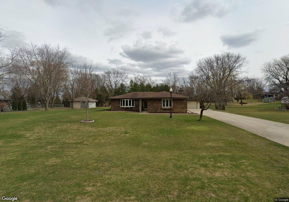
11455 W Shields Dr Franklin, WI 53132
Estimated Value: $444,000 - $517,000
4
Beds
3
Baths
2,315
Sq Ft
$211/Sq Ft
Est. Value
About This Home
This home is located at 11455 W Shields Dr, Franklin, WI 53132 and is currently estimated at $487,722, approximately $210 per square foot. 11455 W Shields Dr is a home located in Milwaukee County with nearby schools including Hales Corners Elementary School, Whitnall Middle School, and Whitnall High School.
Ownership History
Date
Name
Owned For
Owner Type
Purchase Details
Closed on
Jan 3, 2024
Sold by
Zelinski Earl R and Zelinski Bonita M
Bought by
Earl Zelinski & Bonita Lee M Goetz-Zelinski T and Zelinski
Current Estimated Value
Purchase Details
Closed on
Mar 19, 1996
Sold by
Zelinski Earl R
Bought by
Zelinski Earl R and Goetz Zelinski Bonita M
Create a Home Valuation Report for This Property
The Home Valuation Report is an in-depth analysis detailing your home's value as well as a comparison with similar homes in the area
Home Values in the Area
Average Home Value in this Area
Purchase History
| Date | Buyer | Sale Price | Title Company |
|---|---|---|---|
| Earl Zelinski & Bonita Lee M Goetz-Zelinski T | -- | None Listed On Document | |
| Zelinski Earl R | -- | -- |
Source: Public Records
Mortgage History
| Date | Status | Borrower | Loan Amount |
|---|---|---|---|
| Closed | Zelinski Earl R | $0 |
Source: Public Records
Tax History Compared to Growth
Tax History
| Year | Tax Paid | Tax Assessment Tax Assessment Total Assessment is a certain percentage of the fair market value that is determined by local assessors to be the total taxable value of land and additions on the property. | Land | Improvement |
|---|---|---|---|---|
| 2024 | $3,561 | -- | -- | -- |
| 2023 | $5,888 | $390,300 | $74,100 | $316,200 |
| 2022 | $6,152 | $336,700 | $74,100 | $262,600 |
| 2021 | $6,107 | $325,500 | $69,600 | $255,900 |
| 2020 | $6,308 | $0 | $0 | $0 |
| 2019 | $7,096 | $313,000 | $69,600 | $243,400 |
| 2018 | $5,905 | $0 | $0 | $0 |
| 2017 | $6,595 | $274,600 | $69,600 | $205,000 |
| 2015 | -- | $244,400 | $64,000 | $180,400 |
| 2013 | -- | $244,400 | $64,000 | $180,400 |
Source: Public Records
Map
Nearby Homes
- 6749 S Prairie Wood Ln
- 6741 S Prairie Wood Ln
- 11310 Haleco Ln
- 11216 Bridget Ln
- 10464 W Whitnall Edge Dr Unit 203
- 7084 S Fieldstone Ct Unit 43
- 11931 W Janesville Rd
- 10152 W Whitnall Edge Dr Unit E
- 10380 W Whitnall Edge Cir Unit H
- 10264 W Whitnall Edge Cir Unit E
- 10081 W Whitnall Edge Dr Unit F
- 6512 S Parkedge Cir Unit 118B
- 11470 W Tess Creek St
- 11415 W Tess Creek St
- 11532 W Tess Creek St
- 5701 S 121st St
- 11388 W Tess Creek St
- 10555 W Parnell Ave
- 10939 W Coronado Ct
- 11458 W Balboa St
- 11450 W Shields Dr
- 11437 W Shields Dr
- 11436 W Shields Dr
- 11510 W Shields Dr
- 11520 W James Ave
- 11515 W Shields Dr
- 11530 W Shields Dr
- 11535 W James Ave
- 6623 S North Cape Rd
- 6605 S North Cape Rd
- 11535 W Shields Dr
- 6545 S Carroll Cir
- 11540 W James Ave
- 6565 S Carroll Cir
- 6550 S Carroll Cir
- 6641 S North Cape Rd
- 6570 S Carroll Cir
- 11550 W Shields Dr
- 11545 W Shields Dr
- 11550 W James Ave