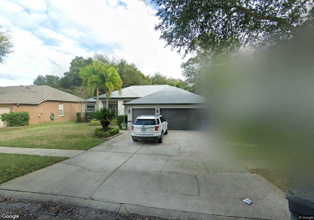
1146 Lumsden Trace Cir Valrico, FL 33594
Estimated Value: $490,676 - $536,000
4
Beds
3
Baths
3,240
Sq Ft
$159/Sq Ft
Est. Value
About This Home
This home is located at 1146 Lumsden Trace Cir, Valrico, FL 33594 and is currently estimated at $513,669, approximately $158 per square foot. 1146 Lumsden Trace Cir is a home located in Hillsborough County with nearby schools including Buckhorn Elementary School, Mulrennan Middle School, and Durant High School.
Ownership History
Date
Name
Owned For
Owner Type
Purchase Details
Closed on
Jul 30, 2019
Sold by
Brown Jamie and Mcguire Jamie
Bought by
Brown Jamie and Brown Jeramiah
Current Estimated Value
Purchase Details
Closed on
Oct 8, 2009
Sold by
Woodring Douglas J and Hardesty Cathryn L
Bought by
Mcguire Jamie
Purchase Details
Closed on
Jan 5, 2001
Sold by
Paragon Homes Corporation
Bought by
Woodring Douglas J and Hardesty Cathryn L
Home Financials for this Owner
Home Financials are based on the most recent Mortgage that was taken out on this home.
Original Mortgage
$151,350
Interest Rate
7.75%
Mortgage Type
New Conventional
Create a Home Valuation Report for This Property
The Home Valuation Report is an in-depth analysis detailing your home's value as well as a comparison with similar homes in the area
Home Values in the Area
Average Home Value in this Area
Purchase History
| Date | Buyer | Sale Price | Title Company |
|---|---|---|---|
| Brown Jamie | -- | None Available | |
| Mcguire Jamie | $222,500 | Hillsborough Title Of Brando | |
| Woodring Douglas J | $169,300 | -- |
Source: Public Records
Mortgage History
| Date | Status | Borrower | Loan Amount |
|---|---|---|---|
| Previous Owner | Woodring Douglas J | $151,350 |
Source: Public Records
Tax History Compared to Growth
Tax History
| Year | Tax Paid | Tax Assessment Tax Assessment Total Assessment is a certain percentage of the fair market value that is determined by local assessors to be the total taxable value of land and additions on the property. | Land | Improvement |
|---|---|---|---|---|
| 2024 | $3,401 | $184,324 | -- | -- |
| 2023 | $3,275 | $178,955 | $0 | $0 |
| 2022 | $3,108 | $173,743 | $0 | $0 |
| 2021 | $3,068 | $168,683 | $0 | $0 |
| 2020 | $2,982 | $166,354 | $0 | $0 |
| 2019 | $3,083 | $157,619 | $0 | $0 |
| 2018 | $2,988 | $154,680 | $0 | $0 |
| 2017 | $2,950 | $214,136 | $0 | $0 |
| 2016 | $2,921 | $148,383 | $0 | $0 |
| 2015 | $2,945 | $147,352 | $0 | $0 |
| 2014 | $2,920 | $146,183 | $0 | $0 |
| 2013 | -- | $144,023 | $0 | $0 |
Source: Public Records
Map
Nearby Homes
- 4207 E Lumsden Rd
- 4106 Jade Ln
- 3911 Smoke Rise Ct
- 4022 Valrico Grove Dr
- 934 Grand Canyon Dr
- 3950 Appletree Dr
- 4233 Amber Ridge Ln
- 1710 Tallowtree Cir
- 4001 Highgate Dr
- 4436 Horseshoe Pick Ln
- 3919 Appletree Dr
- 4139 Yellowwood Dr
- 4514 Highfalls Dr
- 2863 Duncan Tree Cir
- 2864 Duncan Tree Cir
- 4716 Little Denise Ct
- 2803 Bent Leaf Dr
- 2710 Bent Leaf Dr
- 2715 Mock Orange Ct
- 1108 Soaring Osprey Way
- 1148 Lumsden Trace Cir
- 1144 Lumsden Trace Cir
- 1142 Lumsden Trace Cir
- 1150 Lumsden Trace Cir
- 1147 Lumsden Trace Cir
- 1145 Lumsden Trace Cir
- 1140 Lumsden Trace Cir
- 1152 Lumsden Trace Cir
- 1149 Lumsden Trace Cir
- 1143 Lumsden Trace Cir
- 1151 Lumsden Trace Cir
- 1141 Lumsden Trace Cir
- 1154 Lumsden Trace Cir
- 1138 Lumsden Trace Cir
- 1316 S Mulrennan Rd
- 1153 Lumsden Trace Cir
- 1139 Lumsden Trace Cir
- 1113 Lumsden Trace Cir
- 1115 Lumsden Trace Cir
- 1156 Lumsden Trace Cir