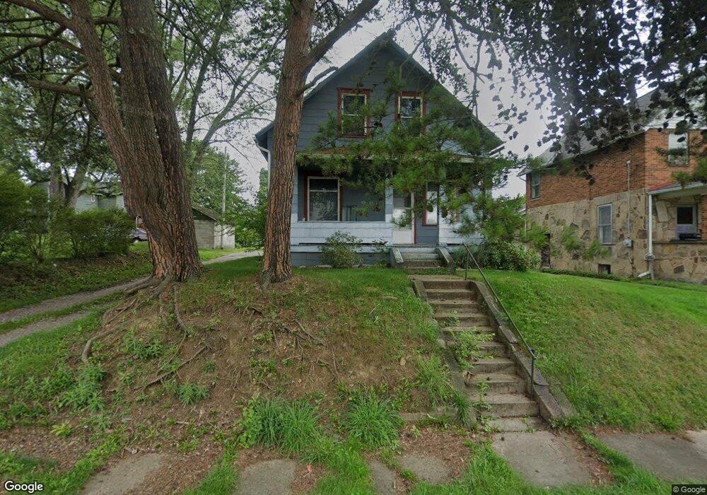
1147 Forest Ave Alliance, OH 44601
Estimated Value: $66,201 - $99,000
4
Beds
2
Baths
1,419
Sq Ft
$58/Sq Ft
Est. Value
About This Home
This home is located at 1147 Forest Ave, Alliance, OH 44601 and is currently estimated at $82,800, approximately $58 per square foot. 1147 Forest Ave is a home located in Stark County with nearby schools including Alliance Elementary School at Rockhill, Alliance Intermediate School at Northside, and Alliance Middle School.
Ownership History
Date
Name
Owned For
Owner Type
Purchase Details
Closed on
Dec 16, 2014
Sold by
Dickson Joseph E
Bought by
Dickson Denise S
Current Estimated Value
Purchase Details
Closed on
Oct 9, 2002
Sold by
Dickson Joseph E and Dickson Denise S
Bought by
Dickson Joseph E and Dickson Denise S
Purchase Details
Closed on
Nov 8, 1996
Sold by
Cerreta Carmen P
Bought by
Dickson Joseph E and Vancamp Denise
Home Financials for this Owner
Home Financials are based on the most recent Mortgage that was taken out on this home.
Original Mortgage
$24,750
Interest Rate
8.26%
Mortgage Type
New Conventional
Create a Home Valuation Report for This Property
The Home Valuation Report is an in-depth analysis detailing your home's value as well as a comparison with similar homes in the area
Home Values in the Area
Average Home Value in this Area
Purchase History
| Date | Buyer | Sale Price | Title Company |
|---|---|---|---|
| Dickson Denise S | -- | None Available | |
| Dickson Joseph E | -- | -- | |
| Dickson Joseph E | $27,500 | -- |
Source: Public Records
Mortgage History
| Date | Status | Borrower | Loan Amount |
|---|---|---|---|
| Closed | Dickson Joseph E | $24,750 |
Source: Public Records
Tax History Compared to Growth
Tax History
| Year | Tax Paid | Tax Assessment Tax Assessment Total Assessment is a certain percentage of the fair market value that is determined by local assessors to be the total taxable value of land and additions on the property. | Land | Improvement |
|---|---|---|---|---|
| 2025 | $4,092 | $18,490 | $2,980 | $15,510 |
| 2024 | $3,146 | $18,490 | $2,980 | $15,510 |
| 2023 | $3,064 | $15,130 | $3,050 | $12,080 |
| 2022 | $618 | $15,130 | $3,050 | $12,080 |
| 2021 | $629 | $15,130 | $3,050 | $12,080 |
| 2020 | $730 | $13,130 | $2,660 | $10,470 |
| 2019 | $576 | $13,130 | $2,660 | $10,470 |
| 2018 | $579 | $13,130 | $2,660 | $10,470 |
| 2017 | $517 | $11,520 | $2,240 | $9,280 |
| 2016 | $521 | $11,520 | $2,240 | $9,280 |
| 2015 | $526 | $11,520 | $2,240 | $9,280 |
| 2014 | $418 | $8,720 | $2,030 | $6,690 |
| 2013 | $209 | $8,720 | $2,030 | $6,690 |
Source: Public Records
Map
Nearby Homes
- 1233 Woodland Ave
- 1395 S Webb Ave
- 814 Milner St
- 1044 S Liberty Ave
- 729 Waugh St
- 831 Wade Ave
- 815 Grace St
- 551 South St
- 1005 S Freedom Ave
- 1437 S Linden Ave
- 452 E Summit St
- 390 E College St
- 442 S Liberty Ave
- 1846 S Freedom Ave
- 167 11th St
- 1475 Chatauqua Ct
- 548 E High St
- 432 S Linden Ave
- V/L S Fredeom Ave
- 404 S Linden Ave
- 1145 Forest Ave
- 1136 South St
- 1136 South St
- 1127 Forest Ave
- 1148 Woodland Ave
- 1150 Forest Ave
- 1140 Woodland Ave
- 1134 Woodland Ave
- 1148 Forest Ave
- 1206 South St
- 1132 Forest Ave
- 1154 Woodland Ave
- 1128 Forest Ave
- 1104 South St
- 1137 Auld St
- 1220 South St
- 1119 Auld St
- 1135 South St
- 1111 Auld St
- 1143 South St