
Seller's Agent in 2026
Amy Van Osdol
Sine & Monaghan LLC
(313) 888-8800
17 in this area
73 Total Sales
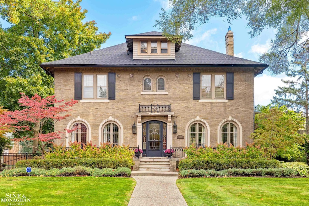
Classic Charm Meets Modern Living in a Premier Park Location. Built in 1926 and thoughtfully updated for today’s lifestyle, this stunning home perfectly blends timeless character with contemporary comfort. Step through leaded glass doors into a home filled with warmth and style. The circular floor plan offers a natural flow, ideal for both everyday living and entertaining. The inviting living room features a beautiful fireplace, creating a cozy gathering space for family and friends. Enjoy meals in the generous formal dining room adorned with elegant crown moldings, or relax in the tiled sunroom filled with natural light. The gourmet kitchen and family room addition serves as the heart of the home — an entertainer’s dream. A convenient mudroom off the back entrance provides built-in hooks and cubbies for easy storage and organization. Upstairs, you’ll find four spacious bedrooms and two full baths, including a serene primary suite with private bath. The third floor offers a flexible bonus suite with bedroom and full bath, perfect for guests or a home office. The finished basement recreation room adds even more space for relaxation or play. Outside, the beautiful backyard and patio provide a perfect setting for entertaining. A two-car detached garage completes this exceptional property. Access to 2 resident-only parks with olympic size pool, tennis courts, marina, picnic areas, ice-skating, and 2 movie theaters. Set on a picturesque street in a desirable Park location, this home offers a rare combination of historic charm and thoughtful modern updates. Be prepared to fall in love!
Last Agent to Sell the Property
Sine & Monaghan LLC License #MISPE-6501371097 Listed on: 10/31/2025
| Date | Type | Sale Price | Title Company |
|---|---|---|---|
| Deed | $638,000 | -- | |
| Deed | -- | -- |
| Date | Event | Price | List to Sale | Price per Sq Ft |
|---|---|---|---|---|
| 01/26/2026 01/26/26 | Sold | $1,025,000 | +3.0% | $221 / Sq Ft |
| 11/09/2025 11/09/25 | Pending | -- | -- | -- |
| 11/06/2025 11/06/25 | For Sale | $995,000 | -- | $214 / Sq Ft |
| Year | Tax Paid | Tax Assessment Tax Assessment Total Assessment is a certain percentage of the fair market value that is determined by local assessors to be the total taxable value of land and additions on the property. | Land | Improvement |
|---|---|---|---|---|
| 2025 | $6,718 | $393,300 | $0 | $0 |
| 2024 | $6,467 | $375,500 | $0 | $0 |
| 2023 | $6,176 | $349,600 | $0 | $0 |
| 2022 | $5,867 | $325,800 | $0 | $0 |
| 2021 | $11,568 | $310,200 | $0 | $0 |
| 2019 | $11,905 | $297,800 | $0 | $0 |
| 2018 | $5,594 | $252,100 | $0 | $0 |
| 2017 | $12,333 | $201,400 | $0 | $0 |
| 2016 | $11,595 | $267,000 | $0 | $0 |
| 2015 | $20,934 | $247,400 | $0 | $0 |
| 2013 | $20,280 | $206,700 | $0 | $0 |
| 2012 | $5,796 | $218,600 | $65,500 | $153,100 |
Seller's Agent in 2026
Amy Van Osdol
Sine & Monaghan LLC
(313) 888-8800
17 in this area
73 Total Sales
Buyer's Agent in 2026
Alexis DeLuca
Real Estate One Grosse Pointe
(313) 330-8394
16 in this area
66 Total Sales
Source: Michigan Multiple Listing Service
MLS Number: 50193087
APN: 39-004-04-0020-000
Disclaimer: Certain information contained herein is derived from information provided by parties other than Homes.com. All information provided is deemed reliable, but is not guaranteed to be accurate and should be independently verified.
![]() Source MLS: MiRealSource
Source MLS: MiRealSource
Provided through IDX via MiRealSource. Courtesy of MiRealSource Shareholder. Copyright MiRealSource.
The information published and disseminated by MiRealSource is communicated verbatim, without change by MiRealSource, as filed with MiRealSource by its members. The accuracy of all information, regardless of source, is not guaranteed or warranted. All information should be independently verified.
Copyright 2026 MiRealSource. All rights reserved. The information provided hereby constitutes proprietary information of MiRealSource, Inc. and its shareholders, affiliates and licensees and may not be reproduced or transmitted in any form or by any means, electronic or mechanical, including photocopy, recording, scanning or any information storage and retrieval system, without written permission from MiRealSource, Inc.
Ask me questions while you tour the home.