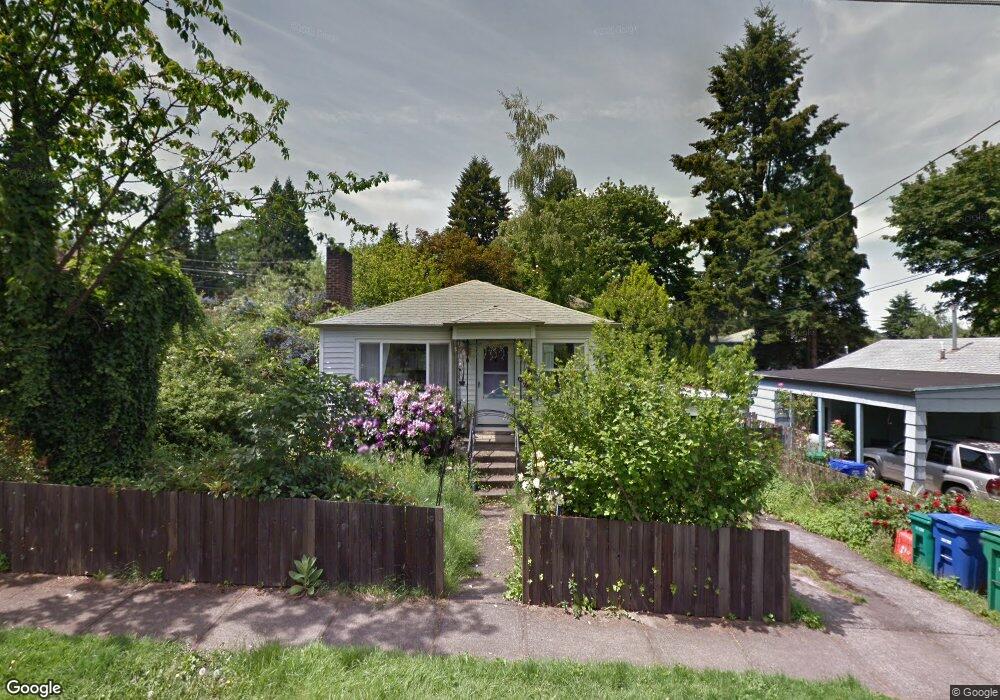
11483 SE 34th Ave Milwaukie, OR 97222
Lake Road NeighborhoodEstimated Value: $422,000 - $481,000
2
Beds
1
Bath
1,550
Sq Ft
$288/Sq Ft
Est. Value
About This Home
This home is located at 11483 SE 34th Ave, Milwaukie, OR 97222 and is currently estimated at $445,671, approximately $287 per square foot. 11483 SE 34th Ave is a home located in Clackamas County with nearby schools including Milwaukie Elementary School, Rowe Middle School, and Milwaukie High School.
Ownership History
Date
Name
Owned For
Owner Type
Purchase Details
Closed on
Aug 10, 2004
Sold by
Sebers Steven L and Sebers Mary S
Bought by
Ambrosio Amy E
Current Estimated Value
Home Financials for this Owner
Home Financials are based on the most recent Mortgage that was taken out on this home.
Original Mortgage
$132,400
Outstanding Balance
$60,228
Interest Rate
4.87%
Mortgage Type
Purchase Money Mortgage
Estimated Equity
$385,443
Create a Home Valuation Report for This Property
The Home Valuation Report is an in-depth analysis detailing your home's value as well as a comparison with similar homes in the area
Home Values in the Area
Average Home Value in this Area
Purchase History
| Date | Buyer | Sale Price | Title Company |
|---|---|---|---|
| Ambrosio Amy E | $165,550 | First American |
Source: Public Records
Mortgage History
| Date | Status | Borrower | Loan Amount |
|---|---|---|---|
| Open | Ambrosio Amy E | $132,400 | |
| Closed | Ambrosio Amy E | $33,100 |
Source: Public Records
Tax History Compared to Growth
Tax History
| Year | Tax Paid | Tax Assessment Tax Assessment Total Assessment is a certain percentage of the fair market value that is determined by local assessors to be the total taxable value of land and additions on the property. | Land | Improvement |
|---|---|---|---|---|
| 2025 | $3,369 | $153,094 | -- | -- |
| 2024 | $3,253 | $148,635 | -- | -- |
| 2023 | $3,253 | $144,306 | $0 | $0 |
| 2022 | $3,004 | $140,103 | $0 | $0 |
| 2021 | $2,899 | $136,023 | $0 | $0 |
| 2020 | $2,809 | $132,062 | $0 | $0 |
| 2019 | $2,767 | $128,216 | $0 | $0 |
| 2018 | $2,461 | $124,482 | $0 | $0 |
| 2017 | $2,390 | $120,856 | $0 | $0 |
| 2016 | $2,310 | $117,336 | $0 | $0 |
| 2015 | $2,200 | $113,918 | $0 | $0 |
| 2014 | $2,086 | $110,600 | $0 | $0 |
Source: Public Records
Map
Nearby Homes
- 11332 SE 31st Ave
- 11265 SE 30th Ave
- 10845 SE Myrtle St
- 10801 SE Myrtle St
- 10638 SE 34th Ave
- 4134 SE Washington St
- 10475 SE 37th Ave
- 10429 SE 36th Ave
- 4119 SE Northridge Dr
- 4025 SE Llewellyn St
- 12632 SE 39th Ct
- 4657 SE Franklin St
- 4512 SE Garrett Cir
- 12425 SE 27th Ave
- 12712 SE 31st Ave
- 12600 SE Freeman Way
- 0 SE Sparrow St
- 12437 SE 24th Ave
- 12815 SE 31st Ave
- 11508 SE 48th Ave
- 11461 SE 34th Ave
- 3315 SE Sellwood St
- 11447 SE 34th Ave
- 3305 SE Sellwood St
- 3326 SE Sellwood St
- 11436 SE 33rd Ave
- 11501 SE 34th Ave
- 11425 SE 34th Ave
- 11484 SE 34th Ave
- 11528 SE 33rd Ave
- 11462 SE 34th Ave
- 11404 SE 33rd Ave
- 11440 SE 34th Ave
- 11506 SE 34th Ave
- 11393 SE 34th Ave
- 11555 SE 34th Ave
- 11392 SE 33rd Ave
- 3412 SE Sellwood St
- 11540 SE 33rd Ave