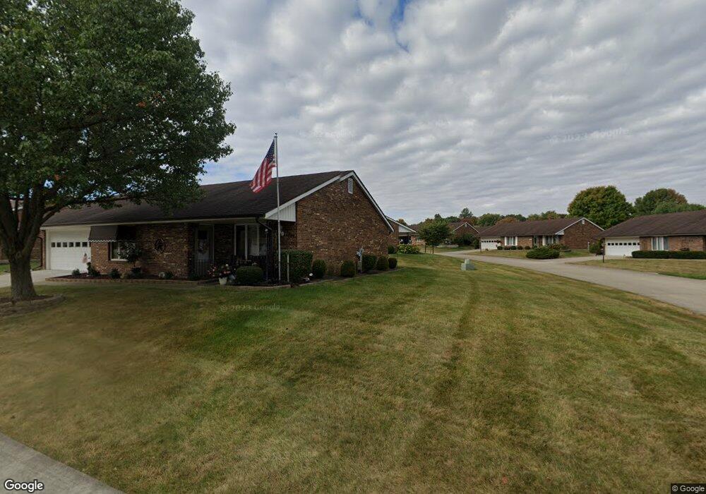
1149 Armsgate Rd Springfield, OH 45503
Estimated Value: $152,000 - $198,000
2
Beds
2
Baths
1,300
Sq Ft
$143/Sq Ft
Est. Value
About This Home
This home is located at 1149 Armsgate Rd, Springfield, OH 45503 and is currently estimated at $185,970, approximately $143 per square foot. 1149 Armsgate Rd is a home located in Clark County with nearby schools including Northridge Elementary School, Kenton Ridge Middle & High School, and Emmanuel Christian Academy.
Ownership History
Date
Name
Owned For
Owner Type
Purchase Details
Closed on
Aug 21, 2020
Sold by
Kampman Robert F and Kampman Melissa M
Bought by
Falace Phyllis M and Phyllis M Falace Trust
Current Estimated Value
Purchase Details
Closed on
Apr 11, 2013
Sold by
Johnson Clair A and Johnson Larry H
Bought by
Kampman Robert F
Home Financials for this Owner
Home Financials are based on the most recent Mortgage that was taken out on this home.
Original Mortgage
$48,000
Interest Rate
3.5%
Mortgage Type
Purchase Money Mortgage
Purchase Details
Closed on
Feb 29, 2008
Sold by
Johnson Larry H and Johnson Larry H
Bought by
Johnson Clair A and Johnson Clair
Purchase Details
Closed on
Jul 21, 1993
Create a Home Valuation Report for This Property
The Home Valuation Report is an in-depth analysis detailing your home's value as well as a comparison with similar homes in the area
Home Values in the Area
Average Home Value in this Area
Purchase History
| Date | Buyer | Sale Price | Title Company |
|---|---|---|---|
| Falace Phyllis M | $125,000 | None Available | |
| Kampman Robert F | $83,000 | None Available | |
| Johnson Clair A | -- | Attorney | |
| -- | $77,000 | -- |
Source: Public Records
Mortgage History
| Date | Status | Borrower | Loan Amount |
|---|---|---|---|
| Previous Owner | Kampman Robert F | $48,000 |
Source: Public Records
Tax History
| Year | Tax Paid | Tax Assessment Tax Assessment Total Assessment is a certain percentage of the fair market value that is determined by local assessors to be the total taxable value of land and additions on the property. | Land | Improvement |
|---|---|---|---|---|
| 2025 | $1,729 | $53,830 | $7,350 | $46,480 |
| 2024 | $1,671 | $40,730 | $6,300 | $34,430 |
| 2023 | $1,671 | $40,730 | $6,300 | $34,430 |
| 2022 | $922 | $40,730 | $6,300 | $34,430 |
| 2021 | $1,723 | $35,870 | $5,250 | $30,620 |
| 2020 | $1,725 | $35,870 | $5,250 | $30,620 |
| 2019 | $1,760 | $35,870 | $5,250 | $30,620 |
| 2018 | $1,638 | $32,320 | $5,570 | $26,750 |
| 2017 | $1,393 | $30,835 | $5,565 | $25,270 |
| 2016 | $1,382 | $30,835 | $5,565 | $25,270 |
| 2015 | $1,246 | $30,520 | $5,250 | $25,270 |
| 2014 | $1,246 | $30,520 | $5,250 | $25,270 |
| 2013 | $858 | $30,520 | $5,250 | $25,270 |
Source: Public Records
Map
Nearby Homes
- 3052 Brixton Dr E
- 1136 Foxboro Rd Unit 202
- 1139 Bradford Dr
- 1039 Bradford Dr Unit 42
- 1201 Kingsgate Rd
- 3631 Kingsgate Ln
- 1500 Kingsgate Rd Unit 19430
- 1502 Kingsgate Rd Unit 19432
- 1500 Kingsgate Rd
- 1502 Kingsgate Rd
- 1162 Kingsgate Rd
- 1503 Kingsgate Rd
- 1507 Kingsgate Rd
- 1505 Kingsgate Rd
- 2022 Westboro Ave
- 1525 Providence Ave
- 3124 El Camino Dr
- 1811 Saint Andrews Ct
- 3135 Imperial Blvd
- 1922 Wedgewood Cir
- 1147 Armsgate Rd
- 1147 Armsgate Rd Unit 144
- 3065 Brixton Dr E
- 3061 Brixton Dr E Unit 147
- 3061 Brixton Dr E
- 1148 Armsgate Rd Unit 183
- 1150 Armsgate Rd Unit 184
- 1150 Armsgate Rd
- 1146 Armsgate Rd Unit 182
- 1145 Armsgate Rd
- 1152 Armsgate Rd
- 3057 Brixton Dr E
- 3057 Brixton Dr E
- 1144 Armsgate Rd Unit 181
- 3064 Brixton Dr E
- 3068 Brixton Dr E Unit 92
- 3060 Brixton Dr E
- 3053 Brixton Dr E
- 1145 Foxboro Rd Unit 190
- 1145 Foxboro Rd
Your Personal Tour Guide
Ask me questions while you tour the home.