Estimated Value: $86,000 - $151,000
Studio
--
Bath
1,218
Sq Ft
$93/Sq Ft
Est. Value
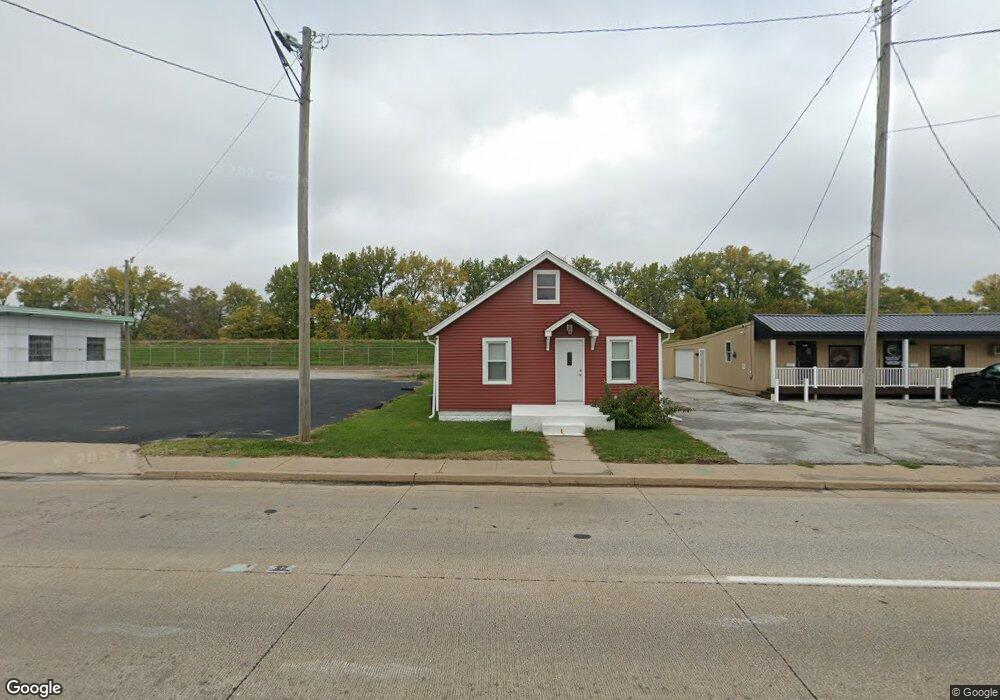
About This Home
This home is located at 115 1st Ave E, Milan, IL 61264 and is currently estimated at $113,564, approximately $93 per square foot. 115 1st Ave E is a home located in Rock Island County with nearby schools including Thomas Jefferson Elementary School, Edison Jr High School, and Rock Island High School.
Ownership History
Date
Name
Owned For
Owner Type
Purchase Details
Closed on
Nov 20, 2023
Sold by
R & J Morgan Llc
Bought by
R and Morgan J
Current Estimated Value
Purchase Details
Closed on
Nov 18, 2019
Sold by
R & J Morgan Llc
Bought by
R & J Morgan Llc and Ra Morgan Enterprises Llc
Purchase Details
Closed on
Jun 3, 2019
Sold by
Qc Land Development Llc
Bought by
R & J Morgan Llc
Purchase Details
Closed on
Nov 20, 2018
Sold by
Sheriff Of Rock Island County
Bought by
Qc Land Development Llc
Purchase Details
Closed on
Dec 1, 2004
Create a Home Valuation Report for This Property
The Home Valuation Report is an in-depth analysis detailing your home's value as well as a comparison with similar homes in the area
Home Values in the Area
Average Home Value in this Area
Purchase History
| Date | Buyer | Sale Price | Title Company |
|---|---|---|---|
| R | -- | None Listed On Document | |
| R & J Morgan Llc | -- | Mack Litonya | |
| R & J Morgan Llc | $112,500 | Lane & Waterman Llp | |
| Qc Land Development Llc | -- | Lane & Waterman Llp | |
| Qc Land Development Llc | -- | Lane & Waterman Llp | |
| -- | $181,000 | -- |
Source: Public Records
Tax History
| Year | Tax Paid | Tax Assessment Tax Assessment Total Assessment is a certain percentage of the fair market value that is determined by local assessors to be the total taxable value of land and additions on the property. | Land | Improvement |
|---|---|---|---|---|
| 2024 | $1,998 | $21,681 | $5,472 | $16,209 |
| 2023 | $1,998 | $20,263 | $5,114 | $15,149 |
| 2022 | $1,798 | $18,693 | $4,718 | $13,975 |
| 2021 | $1,786 | $17,702 | $4,468 | $13,234 |
| 2020 | $1,750 | $17,254 | $4,355 | $12,899 |
| 2019 | $1,835 | $17,858 | $8,628 | $9,230 |
| 2018 | $1,784 | $17,647 | $8,526 | $9,121 |
| 2017 | $1,629 | $17,318 | $8,367 | $8,951 |
| 2016 | $1,590 | $17,231 | $8,325 | $8,906 |
| 2015 | $1,594 | $17,140 | $8,281 | $8,859 |
| 2014 | $358 | $16,771 | $8,103 | $8,668 |
| 2013 | $358 | $16,771 | $8,103 | $8,668 |
Source: Public Records
Map
Nearby Homes
- 115 1st Ave E
- 103 2nd Ave E
- 115 2nd Ave E
- 121 2nd Ave E
- 127 2nd Ave E
- 129 2nd Ave E
- 129 - 129 1 2 E 2nd
- 109 2nd Ave W Unit 2
- 109 2nd Ave W
- 204 1st Ave E
- 204 1st Ave E
- Lot205 Sheet 48 Ridgewood
- 113 2nd Ave W
- 133 1st Ave W
- 119 2nd Ave W
- 203 2nd Ave E
- 108 2nd Ave E
- 111 2nd St W
- 122 2nd Ave E
- 116 2nd Ave E
Your Personal Tour Guide
Ask me questions while you tour the home.