
Seller's Agent in 2025
Joseph Passero
William Raveis Real Estate
(203) 247-7723
2 in this area
33 Total Sales
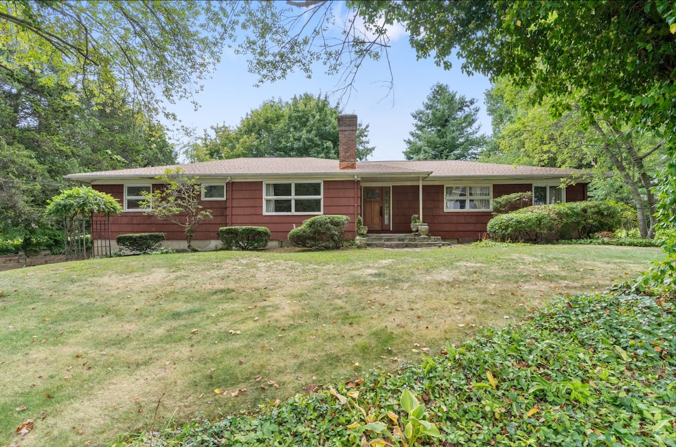
Welcome to Beautiful Balmforth St in the Heart Of Black Rock's Historic Waterfront Community. This charming home sits on a beautiful tree lined street leading directly to the water on over 1/3 flat acre. This rare ranch style home offers over 2600 sq.ft.all on one level. Relax in the oversized living room with original custom woodwork and hardwood floors. Entertain in a formal dining room and gather in the home's oversized kitchen with separate breakfast area. Expansive sun room overlooks the properties quaint landscaping through a wall of windows.There are 4 bedrooms and 2.5 bathrooms, original floors in most rooms and 2 wood burning fireplaces. Full multi purpose lower level is previously finished and leads to an oversized 2 car garage. Complete new roof installed in 2025 This home needs some TLC to bring to its original glory. Black Rock is one of Fairfield County's most desirable communities. This home is in very close proximity to Black Rock Yacht Club and St.Mary's By The Sea. This type of home comes along infrequently. Make an appointment for your private showing today.
Last Agent to Sell the Property
William Raveis Real Estate Brokerage Phone: (203) 247-7723 License #RES.0811377 Listed on: 09/25/2025
| Date | Type | Sale Price | Title Company |
|---|---|---|---|
| Warranty Deed | $765,000 | -- | |
| Warranty Deed | $363,500 | -- | |
| Warranty Deed | $363,500 | -- |
| Date | Status | Loan Amount | Loan Type |
|---|---|---|---|
| Open | $612,000 | New Conventional | |
| Previous Owner | $143,000 | No Value Available | |
| Previous Owner | $377,944 | No Value Available | |
| Previous Owner | $403,000 | No Value Available | |
| Previous Owner | $348,500 | No Value Available |
| Date | Event | Price | List to Sale | Price per Sq Ft |
|---|---|---|---|---|
| 10/31/2025 10/31/25 | Sold | $765,000 | +5.5% | $291 / Sq Ft |
| 09/30/2025 09/30/25 | Pending | -- | -- | -- |
| 09/25/2025 09/25/25 | For Sale | $725,000 | -- | $276 / Sq Ft |
| Year | Tax Paid | Tax Assessment Tax Assessment Total Assessment is a certain percentage of the fair market value that is determined by local assessors to be the total taxable value of land and additions on the property. | Land | Improvement |
|---|---|---|---|---|
| 2025 | $13,812 | $317,890 | $176,900 | $140,990 |
| 2024 | $13,812 | $317,890 | $176,900 | $140,990 |
| 2023 | $13,812 | $317,890 | $176,900 | $140,990 |
| 2022 | $13,812 | $317,890 | $176,900 | $140,990 |
| 2021 | $13,812 | $317,890 | $176,900 | $140,990 |
| 2020 | $17,107 | $316,860 | $199,860 | $117,000 |
| 2019 | $17,107 | $316,860 | $199,860 | $117,000 |
| 2018 | $17,228 | $316,860 | $199,860 | $117,000 |
| 2017 | $17,228 | $316,860 | $199,860 | $117,000 |
| 2016 | $17,228 | $316,860 | $199,860 | $117,000 |
| 2015 | $14,282 | $338,430 | $159,070 | $179,360 |
| 2014 | $14,282 | $338,430 | $159,070 | $179,360 |
Seller's Agent in 2025
Joseph Passero
William Raveis Real Estate
(203) 247-7723
2 in this area
33 Total Sales
Buyer's Agent in 2025
Lindsay Violette
Houlihan Lawrence
(203) 769-9811
1 in this area
40 Total Sales
Source: SmartMLS
MLS Number: 24124096
APN: BRID-000123-000007
Disclaimer: Certain information contained herein is derived from information provided by parties other than Homes.com. All information provided is deemed reliable, but is not guaranteed to be accurate and should be independently verified.
![]() IDX information is provided exclusively for personal, non-commercial use, and may not be used for any purpose other than to identify prospective properties consumers may be interested in purchasing. Information is deemed reliable but not guaranteed.
IDX information is provided exclusively for personal, non-commercial use, and may not be used for any purpose other than to identify prospective properties consumers may be interested in purchasing. Information is deemed reliable but not guaranteed.
Ask me questions while you tour the home.