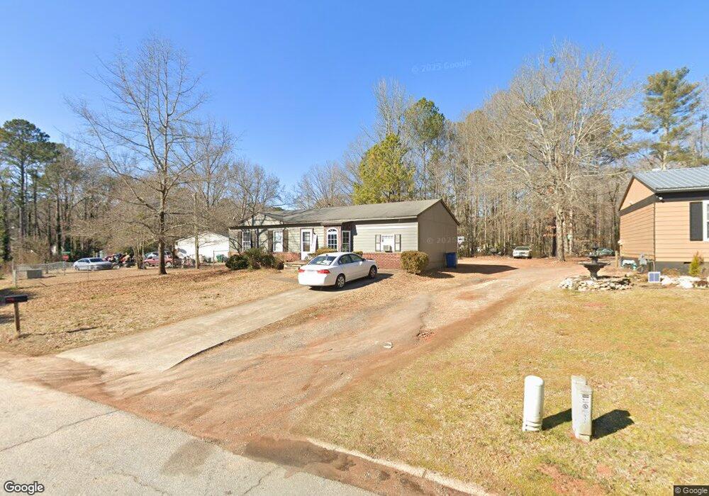
115 Bluestone Dr Bogart, GA 30622
Estimated Value: $133,000 - $270,000
3
Beds
1
Bath
1,310
Sq Ft
$159/Sq Ft
Est. Value
About This Home
This home is located at 115 Bluestone Dr, Bogart, GA 30622 and is currently estimated at $208,009, approximately $158 per square foot. 115 Bluestone Dr is a home located in Clarke County with nearby schools including Cleveland Road Elementary School, Burney-Harris-Lyons Middle School, and Clarke Central High School.
Ownership History
Date
Name
Owned For
Owner Type
Purchase Details
Closed on
Feb 6, 2012
Current Estimated Value
Purchase Details
Closed on
Dec 17, 2010
Sold by
Community Bank
Bought by
Patman Stacy L
Purchase Details
Closed on
Nov 3, 2009
Sold by
Champion Charles
Bought by
Community Bank & Trust
Purchase Details
Closed on
Feb 3, 2006
Sold by
Not Provided
Bought by
Patman Stacy L
Home Financials for this Owner
Home Financials are based on the most recent Mortgage that was taken out on this home.
Original Mortgage
$42,250
Interest Rate
6.14%
Mortgage Type
New Conventional
Purchase Details
Closed on
Jan 31, 2000
Sold by
Schuler Linda Lee
Bought by
Lindavid Properties Inc
Purchase Details
Closed on
Mar 12, 1997
Sold by
Hendrix Roger Allen and Debra Ann
Bought by
Schuler Linda Lee
Purchase Details
Closed on
Jul 30, 1990
Sold by
Sanders Dolores Ann
Bought by
Hendrix Roger Allen and Debra Ann
Create a Home Valuation Report for This Property
The Home Valuation Report is an in-depth analysis detailing your home's value as well as a comparison with similar homes in the area
Purchase History
| Date | Buyer | Sale Price | Title Company |
|---|---|---|---|
| -- | -- | -- | |
| Patman Stacy L | $26,000 | -- | |
| Community Bank & Trust | -- | -- | |
| Patman Stacy L | $41,000 | -- | |
| Lindavid Properties Inc | $10,000 | -- | |
| Schuler Linda Lee | $60,000 | -- | |
| Hendrix Roger Allen | $25,500 | -- |
Source: Public Records
Mortgage History
| Date | Status | Borrower | Loan Amount |
|---|---|---|---|
| Previous Owner | Patman Stacy L | $42,250 |
Source: Public Records
Tax History Compared to Growth
Tax History
| Year | Tax Paid | Tax Assessment Tax Assessment Total Assessment is a certain percentage of the fair market value that is determined by local assessors to be the total taxable value of land and additions on the property. | Land | Improvement |
|---|---|---|---|---|
| 2025 | $1,401 | $45,135 | $12,000 | $33,135 |
| 2024 | $1,401 | $41,834 | $12,000 | $29,834 |
| 2023 | $850 | $27,197 | $10,400 | $16,797 |
| 2022 | $771 | $24,180 | $10,400 | $13,780 |
| 2021 | $623 | $18,490 | $5,600 | $12,890 |
| 2020 | $614 | $18,225 | $5,600 | $12,625 |
| 2019 | $548 | $16,137 | $5,600 | $10,537 |
| 2018 | $526 | $15,484 | $4,800 | $10,684 |
| 2017 | $486 | $14,305 | $4,800 | $9,505 |
| 2016 | $453 | $13,352 | $4,800 | $8,552 |
| 2015 | $428 | $12,600 | $4,800 | $7,800 |
| 2014 | $441 | $12,963 | $4,800 | $8,163 |
Source: Public Records
Map
Nearby Homes
- 125 Bluestone Dr
- 105 Bluestone Dr
- 293 Marlborough Downs Rd
- 293 Marlborough Downs Rd
- 305 Marlborough Downs Rd
- 120 Bluestone Dr
- 300 Marlborough Downs Rd
- 130 Bluestone Dr
- 285 Marlborough Downs Rd
- 110 Bluestone Dr
- 193 Sarsen Cir
- 290 Marborough Downs Rd
- 185 Sarsen Cir
- 290 Marlborough Downs Rd
- 315 Marlborough Downs Rd Unit lot 24
- 315 Marlborough Downs Rd
- 315 Marlborough Downs Rd Unit Lot 5
- 315 Marlborough Downs Rd Unit Lot 24
- 315 Marlborough Downs Rd
- 315 Marlborough Downs Rd