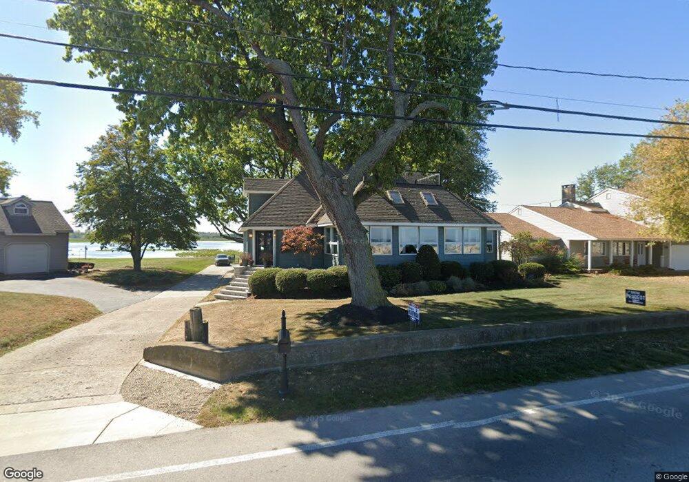
115 Cedar Point Rd Sandusky, OH 44870
Estimated Value: $523,000 - $811,000
3
Beds
4
Baths
3,319
Sq Ft
$209/Sq Ft
Est. Value
About This Home
This home is located at 115 Cedar Point Rd, Sandusky, OH 44870 and is currently estimated at $692,449, approximately $208 per square foot. 115 Cedar Point Rd is a home located in Erie County with nearby schools including Sandusky High School.
Ownership History
Date
Name
Owned For
Owner Type
Purchase Details
Closed on
Jun 19, 1998
Sold by
Kozak James H
Bought by
Mahoney Timothy J and Mahoney Constance M
Current Estimated Value
Home Financials for this Owner
Home Financials are based on the most recent Mortgage that was taken out on this home.
Original Mortgage
$136,000
Outstanding Balance
$27,610
Interest Rate
7.22%
Mortgage Type
New Conventional
Estimated Equity
$664,839
Create a Home Valuation Report for This Property
The Home Valuation Report is an in-depth analysis detailing your home's value as well as a comparison with similar homes in the area
Purchase History
| Date | Buyer | Sale Price | Title Company |
|---|---|---|---|
| Mahoney Timothy J | $239,000 | -- |
Source: Public Records
Mortgage History
| Date | Status | Borrower | Loan Amount |
|---|---|---|---|
| Open | Mahoney Timothy J | $136,000 |
Source: Public Records
Tax History
| Year | Tax Paid | Tax Assessment Tax Assessment Total Assessment is a certain percentage of the fair market value that is determined by local assessors to be the total taxable value of land and additions on the property. | Land | Improvement |
|---|---|---|---|---|
| 2024 | $7,363 | $197,403 | $71,736 | $125,667 |
| 2023 | $7,605 | $150,458 | $51,240 | $99,218 |
| 2022 | $7,452 | $150,458 | $51,240 | $99,218 |
| 2021 | $7,521 | $150,460 | $51,240 | $99,220 |
| 2020 | $7,415 | $136,400 | $51,240 | $85,160 |
| 2019 | $7,628 | $136,400 | $51,240 | $85,160 |
| 2018 | $7,637 | $136,400 | $51,240 | $85,160 |
| 2017 | $7,562 | $134,650 | $55,850 | $78,800 |
| 2016 | $7,559 | $134,650 | $55,850 | $78,800 |
| 2015 | $6,823 | $134,650 | $55,850 | $78,800 |
| 2014 | $6,782 | $134,650 | $55,850 | $78,800 |
| 2013 | $6,008 | $120,520 | $55,850 | $64,670 |
Source: Public Records
Map
Nearby Homes
- 139 Cedar Point Rd
- 720 Tracht Meadows Dr
- 939 Cedar Point Rd
- 3110 Gabriels Place
- 712 Elizabeth Dr
- 2912 Park Ln
- 3117 E Bayview Ln
- 0 Turfside Cir
- 21 Turfside Cir
- 3104 Hull Rd
- 2802 N Bayview Ln
- 0 Galloway Rd Unit 5196064
- 0 Galloway Rd Unit 20260998
- 2815 E Perkins Ave
- 2906 E Perkins Ave
- 3037 Lauras Ln
- 3135 Lauras Ln
- 3132 Lauras Ln
- 3014 Angels Pointe Dr
- 3125 Alexandrias Dr
- 117 Cedar Point Rd
- 109 Cedar Point Rd
- 109 Cedar Point Rd
- 123 Cedar Point Rd
- 103 Cedar Point Rd
- 127 Cedar Point Rd
- 129 Cedar Point Rd
- 101 Cedar Point Rd
- 133 Cedar Point Rd
- 135 Cedar Point Rd
- 39 Cedar Point Rd
- 37 Cedar Point Rd
- 37 Cedar Point Rd
- 37 Cedar Point Rd
- 37 Cedar Point Rd
- 35 Cedar Point Rd
- 35 Cedar Point Rd
- 35 Cedar Point Rd
- 35 Cedar Point Rd
- 35 Cedar Point Rd
Your Personal Tour Guide
Ask me questions while you tour the home.