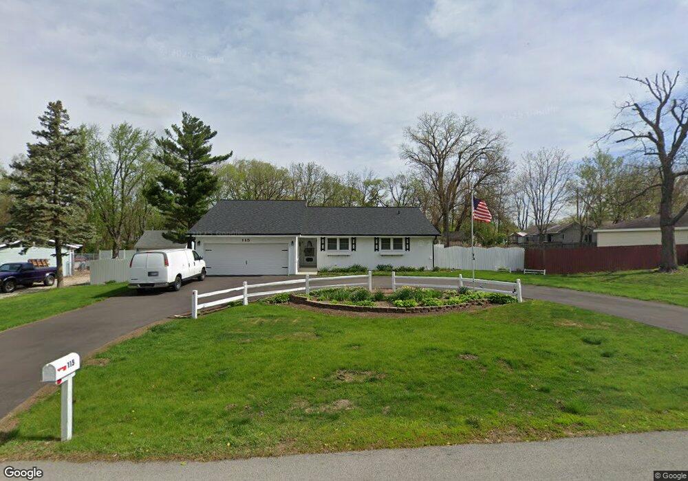
115 Central Rd New Lenox, IL 60451
Estimated Value: $322,989 - $401,000
--
Bed
--
Bath
--
Sq Ft
0.44
Acres
About This Home
This home is located at 115 Central Rd, New Lenox, IL 60451 and is currently estimated at $370,747. 115 Central Rd is a home located in Will County with nearby schools including Bentley Elementary School, Arnold J Tyler School, and Alex M Martino Jr High School.
Ownership History
Date
Name
Owned For
Owner Type
Purchase Details
Closed on
Oct 4, 2001
Sold by
Smith Patricia C
Bought by
Balke Robert J and Balke Jeanie M
Current Estimated Value
Home Financials for this Owner
Home Financials are based on the most recent Mortgage that was taken out on this home.
Original Mortgage
$145,000
Outstanding Balance
$56,883
Interest Rate
6.92%
Estimated Equity
$313,864
Create a Home Valuation Report for This Property
The Home Valuation Report is an in-depth analysis detailing your home's value as well as a comparison with similar homes in the area
Home Values in the Area
Average Home Value in this Area
Purchase History
| Date | Buyer | Sale Price | Title Company |
|---|---|---|---|
| Balke Robert J | $195,000 | Chicago Title Insurance Co |
Source: Public Records
Mortgage History
| Date | Status | Borrower | Loan Amount |
|---|---|---|---|
| Open | Balke Robert J | $145,000 |
Source: Public Records
Tax History Compared to Growth
Tax History
| Year | Tax Paid | Tax Assessment Tax Assessment Total Assessment is a certain percentage of the fair market value that is determined by local assessors to be the total taxable value of land and additions on the property. | Land | Improvement |
|---|---|---|---|---|
| 2024 | $6,663 | $107,614 | $26,818 | $80,796 |
| 2023 | $6,663 | $98,099 | $24,447 | $73,652 |
| 2022 | $7,062 | $90,372 | $22,521 | $67,851 |
| 2021 | $6,923 | $84,992 | $21,180 | $63,812 |
| 2020 | $6,721 | $81,959 | $20,424 | $61,535 |
| 2019 | $6,429 | $79,418 | $19,791 | $59,627 |
| 2018 | $6,276 | $76,681 | $19,109 | $57,572 |
| 2017 | $5,960 | $74,477 | $18,560 | $55,917 |
| 2016 | $5,782 | $72,483 | $18,063 | $54,420 |
| 2015 | $5,566 | $70,201 | $17,494 | $52,707 |
| 2014 | $5,566 | $69,334 | $17,278 | $52,056 |
| 2013 | $5,566 | $70,269 | $17,511 | $52,758 |
Source: Public Records
Map
Nearby Homes
- 105 Roy St
- 00 NE Corner Cherry Hill Road and Moss Lane Rd
- 319 S Pine St
- 718 S Prairie Rd
- 15707 Valley View St
- 808 Stonegate Rd
- 416 Manor Ct Unit B
- 574 Prairie Crossing Dr
- 235 Roberts Rd
- 328 E Lincoln Hwy
- 524 Waverly Ct Unit D
- 218 Manor Dr Unit A
- 203 Tonell Ave
- 329 Hancock Dr
- 1046 Schoolgate Rd Unit 3
- 709 Young Dr
- 920 Barnside Rd
- 331 Old Hickory Rd
- 449 Somerset Ln Unit 1
- 1017 E Lincoln Hwy
- 119 Central Rd
- 111 Central Rd
- 541 S Cedar Rd
- 135 Central Rd
- 000 S Cedar Rd
- 0000 S Cedar Rd
- 0 S Cedar Rd
- 0 S Cedar Rd Unit 8353603
- 0 S Cedar Rd Unit 8511725
- 107 Central Rd
- 519 S Cedar Rd
- 130 Central Rd
- 114 Central Rd
- 140 Central Rd
- 603 S Cedar Rd
- 147 Central Rd
- 124 W 4th Ave
- 509 S Cedar Rd
- 148 Central Rd
- 550 S Pine St